Remote sensing involves capturing data about the Earth's surface using satellite or aerial imagery, allowing for detailed environmental monitoring and analysis. This technology supports various applications, including agriculture, disaster management, and urban planning, through the collection of accurate and timely information. Discover how remote sensing can transform your understanding of spatial data by exploring the full article.
Table of Comparison
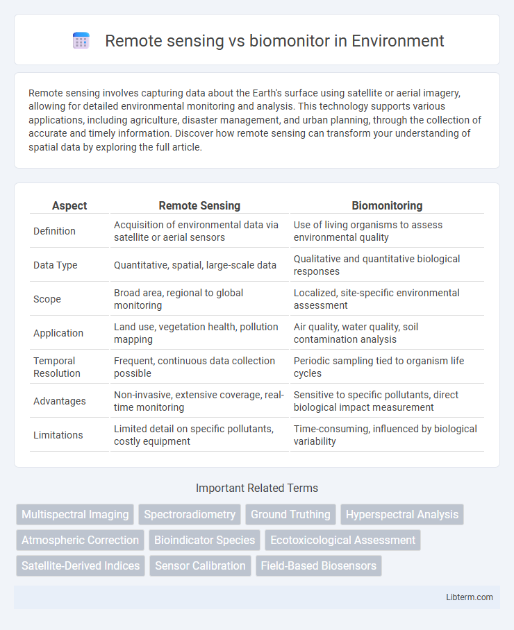
| Aspect | Remote Sensing | Biomonitoring |
|---|---|---|
| Definition | Acquisition of environmental data via satellite or aerial sensors | Use of living organisms to assess environmental quality |
| Data Type | Quantitative, spatial, large-scale data | Qualitative and quantitative biological responses |
| Scope | Broad area, regional to global monitoring | Localized, site-specific environmental assessment |
| Application | Land use, vegetation health, pollution mapping | Air quality, water quality, soil contamination analysis |
| Temporal Resolution | Frequent, continuous data collection possible | Periodic sampling tied to organism life cycles |
| Advantages | Non-invasive, extensive coverage, real-time monitoring | Sensitive to specific pollutants, direct biological impact measurement |
| Limitations | Limited detail on specific pollutants, costly equipment | Time-consuming, influenced by biological variability |
Introduction to Remote Sensing and Biomonitoring
Remote sensing involves the acquisition of information about Earth's surface using satellite or aerial sensor technologies, enabling large-scale environmental monitoring and data collection without direct contact. Biomonitoring, by contrast, uses living organisms such as plants, animals, or microorganisms to assess the health of ecosystems and detect environmental changes or pollution levels. While remote sensing provides broad spatial and temporal environmental data, biomonitoring offers detailed biological responses to environmental stressors, making both methods complementary in ecological assessment.
Defining Remote Sensing
Remote sensing involves the acquisition of information about Earth's surface or atmosphere through satellite or aerial sensor technologies without physical contact. This method captures data on environmental variables such as vegetation cover, land use, and atmospheric conditions by detecting reflected or emitted radiation across various spectral bands. Unlike biomonitoring, which uses living organisms to assess environmental health, remote sensing provides large-scale, real-time spatial data essential for analyzing ecosystems, climate change, and natural resource management.
Understanding Biomonitoring
Biomonitoring involves using living organisms, such as plants or animals, to assess environmental health and detect pollutants over time, providing direct biological evidence of ecosystem changes. Remote sensing, in contrast, relies on satellite or aerial sensor technologies to collect data on environmental conditions from a distance, offering broad spatial coverage but indirect measurements. Understanding biomonitoring emphasizes its capacity to reveal site-specific ecological impacts and bioaccumulation of contaminants that remote sensing might overlook.
Key Technologies and Tools Used
Remote sensing utilizes satellite imagery, LiDAR, and multispectral sensors to capture large-scale environmental data for monitoring land use, vegetation health, and atmospheric changes. Biomonitoring relies on bioindicator species, DNA barcoding, and automated sensor networks to assess ecosystem health, pollutant levels, and species diversity at finer biological scales. Both technologies employ GIS platforms and data analytics for spatial and temporal analysis, enhancing environmental management and conservation efforts.
Data Collection Methods: Remote vs Biomonitor
Remote sensing utilizes satellite imagery, aerial photography, and sensor-based technologies to collect large-scale environmental data such as land cover, vegetation health, and atmospheric conditions. Biomonitoring relies on living organisms, like lichens, insects, or aquatic species, to assess environmental quality by measuring physiological or population changes caused by pollutants. Remote sensing offers continuous, expansive spatial coverage, whereas biomonitoring provides localized, species-specific insights into ecosystem health and pollutant effects.
Advantages of Remote Sensing
Remote sensing offers extensive spatial coverage, enabling the monitoring of large and inaccessible areas with high-resolution satellite or aerial imagery. It provides timely data collection, allowing for real-time or frequent updates critical in environmental management, disaster response, and climate studies. Remote sensing reduces human error and physical risks associated with fieldwork, making it a cost-effective and efficient method for continuous ecological and land-use monitoring.
Strengths of Biomonitoring
Biomonitoring excels in assessing environmental health through direct measurement of biological responses, providing integrative data over time that captures cumulative pollutant exposure. Unlike remote sensing, biomonitoring reflects bioavailability and ecological impact, offering insights into toxic effects on organisms and ecosystems. This method detects subtle biological changes that remote sensing may overlook, enabling more precise evaluation of environmental quality and risks.
Applications in Environmental Monitoring
Remote sensing utilizes satellite or aerial sensor technologies to detect and monitor environmental changes on a large scale, including deforestation, urban sprawl, and water quality assessment. Biomonitoring employs living organisms such as lichens, mosses, or aquatic species to evaluate the health of ecosystems by detecting chemical pollutants, heavy metals, and biological stressors in real-time conditions. Integrating remote sensing data with biomonitoring results enhances accuracy in environmental assessments and supports comprehensive ecosystem management strategies.
Comparative Analysis: Remote Sensing vs Biomonitor
Remote sensing utilizes satellite or aerial sensor technologies to collect large-scale environmental data, enabling real-time monitoring of land, water, and atmospheric conditions with high spatial resolution. Biomonitoring employs living organisms as indicators to assess ecological health and pollutant levels, offering detailed biological responses but limited spatial coverage. Comparative analysis shows remote sensing excels in broad, continuous environmental surveillance, while biomonitoring provides precise, biologically relevant insights for localized ecosystem assessments.
Choosing the Right Approach for Specific Scenarios
Remote sensing offers comprehensive spatial data ideal for large-scale environmental monitoring and detecting ecosystem changes over time, while biomonitoring provides detailed information on biological responses within specific habitats, essential for assessing pollution impacts and biodiversity health. Selecting the right approach depends on factors such as study scale, required data resolution, budget constraints, and the specific ecological parameters of interest. Integrating both methods can enhance accuracy by combining broad landscape analysis with localized biological assessments.
Remote sensing Infographic