Remote sensing enables the collection of data about Earth's surface without direct contact, utilizing satellite imagery and aerial sensors to monitor environmental changes and natural resources. Advanced technologies in remote sensing improve accuracy in mapping, disaster management, and agricultural monitoring, providing critical information for decision-making. Discover how remote sensing can enhance your understanding of our planet by exploring the full article.
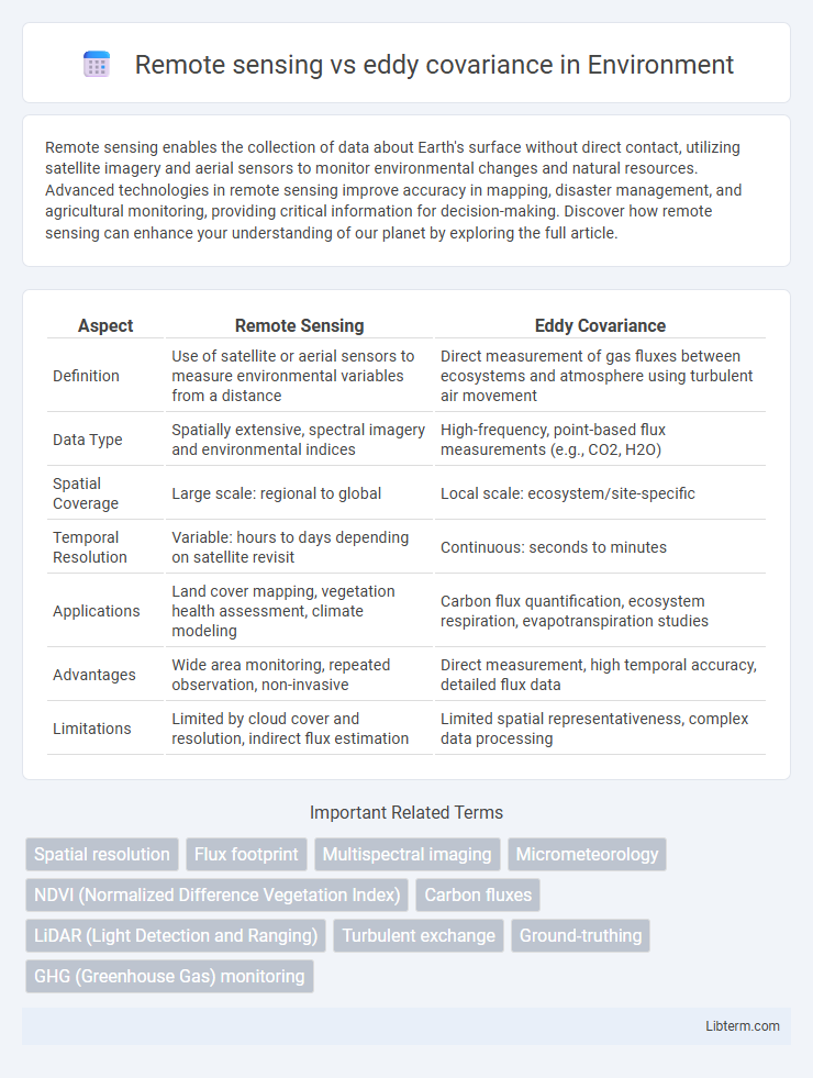
Table of Comparison
| Aspect | Remote Sensing | Eddy Covariance |
|---|---|---|
| Definition | Use of satellite or aerial sensors to measure environmental variables from a distance | Direct measurement of gas fluxes between ecosystems and atmosphere using turbulent air movement |
| Data Type | Spatially extensive, spectral imagery and environmental indices | High-frequency, point-based flux measurements (e.g., CO2, H2O) |
| Spatial Coverage | Large scale: regional to global | Local scale: ecosystem/site-specific |
| Temporal Resolution | Variable: hours to days depending on satellite revisit | Continuous: seconds to minutes |
| Applications | Land cover mapping, vegetation health assessment, climate modeling | Carbon flux quantification, ecosystem respiration, evapotranspiration studies |
| Advantages | Wide area monitoring, repeated observation, non-invasive | Direct measurement, high temporal accuracy, detailed flux data |
| Limitations | Limited by cloud cover and resolution, indirect flux estimation | Limited spatial representativeness, complex data processing |
Introduction to Remote Sensing and Eddy Covariance
Remote sensing utilizes satellite or aerial sensors to capture large-scale environmental data, enabling the monitoring of land surface temperature, vegetation health, and atmospheric composition over vast areas. Eddy covariance measures vertical turbulent fluxes of gases, such as carbon dioxide and water vapor, using high-frequency sensors at specific ground sites to provide detailed, real-time data on ecosystem gas exchange processes. Integrating remote sensing with eddy covariance enhances the understanding of spatial and temporal variations in ecosystem fluxes, supporting climate modeling and ecological management.
Fundamental Principles of Remote Sensing
Remote sensing captures large-scale environmental data by detecting electromagnetic radiation reflected or emitted from Earth's surface, enabling observation of temperature, vegetation health, and land cover. Eddy covariance, in contrast, measures fluxes of gases like CO2 and water vapor directly at a specific site by analyzing vertical wind and scalar concentrations in real time. Remote sensing relies on passive or active sensor platforms such as satellites and drones to provide spatially continuous data, whereas eddy covariance offers high temporal resolution measurements limited to localized ecosystems.
Core Concepts of Eddy Covariance Technique
The eddy covariance technique measures turbulent fluxes of gases, heat, and momentum between the Earth's surface and the atmosphere by capturing rapid variations in wind speed and scalar concentrations using fast-response sensors. This method relies on high-frequency measurements to calculate covariance between vertical wind velocity and scalar quantities, enabling direct estimation of ecosystem exchange processes such as carbon dioxide and water vapor fluxes. Compared to remote sensing, which provides spatially extensive but indirect and time-averaged surface property data, eddy covariance offers precise, continuous, point-scale flux measurements essential for validating and interpreting broader-scale observations.
Spatial and Temporal Resolution Comparison
Remote sensing provides wide spatial coverage with resolutions ranging from meters to kilometers, enabling monitoring over extensive areas, while eddy covariance offers high temporal resolution measurements at specific localized sites, capturing flux data at intervals as fine as 10-30 minutes. The spatial resolution of eddy covariance is limited to the sensor's footprint, typically a few hundred meters, contrasting with remote sensing's ability to cover landscapes and regions simultaneously. Remote sensing's temporal resolution depends on satellite revisit times, which can range from daily to several weeks, whereas eddy covariance delivers continuous, near-real-time flux observations essential for understanding ecosystem processes.
Applications in Environmental Monitoring
Remote sensing offers large-scale environmental monitoring by capturing spatial data on land cover, vegetation health, and climate variables using satellite or aerial imagery. Eddy covariance provides high-frequency, localized measurements of gas fluxes such as carbon dioxide and water vapor exchange between ecosystems and the atmosphere, essential for studying ecosystem respiration and photosynthesis. Combining remote sensing with eddy covariance data enhances accuracy in modeling carbon budgets, tracking climate change effects, and managing natural resources.
Strengths and Limitations of Remote Sensing
Remote sensing excels in providing large-scale, spatially continuous data, enabling comprehensive monitoring of land surface conditions and vegetation dynamics over vast areas. However, it faces limitations in temporal resolution and atmospheric interference, which can affect data accuracy and consistency. Remote sensing struggles with capturing fine-scale physiological processes and direct flux measurements, areas where eddy covariance techniques offer precise, localized measurements of gas exchanges.
Advantages and Challenges of Eddy Covariance
Eddy covariance provides high-frequency, direct measurements of gas fluxes between ecosystems and the atmosphere, enabling precise monitoring of CO2, water vapor, and energy exchange with minimal spatial uncertainty. The technique captures real-time responses to environmental changes, making it invaluable for ecosystem process studies and validating remote sensing data. Challenges include the need for complex, expensive instrumentation, sensitivity to atmospheric turbulence conditions, and limited spatial representativeness due to localized measurement footprints.
Data Integration and Synergy Between Methods
Remote sensing provides large-scale spatial data by capturing spectral signatures across landscapes, complementing the high-frequency, site-specific measurements of carbon and water fluxes obtained through eddy covariance. Integrating these methods enhances ecosystem monitoring by combining remote sensing's broad spatial coverage with eddy covariance's precise temporal resolution, enabling more accurate quantification of carbon budgets and vegetation dynamics. This synergy leverages satellite-derived vegetation indices and flux tower data to improve ecosystem modeling and climate impact assessments.
Case Studies: Remote Sensing vs. Eddy Covariance in Practice
Case studies comparing remote sensing and eddy covariance reveal distinct advantages in ecosystem monitoring, with remote sensing offering broad spatial coverage for assessing vegetation dynamics and land surface temperature, while eddy covariance provides precise, site-specific measurements of gas fluxes such as CO2 and water vapor. In agricultural settings, remote sensing enables large-scale crop health assessment through NDVI indices, whereas eddy covariance systems capture real-time carbon exchange and evapotranspiration rates critical for optimizing irrigation and fertilization. Combining these methods enhances ecosystem productivity modeling and carbon budgeting by integrating spatially extensive data with high-frequency flux measurements for improved environmental management.
Future Trends and Technological Advancements
Future trends in remote sensing emphasize enhanced spatial and temporal resolution through the integration of AI-driven data analytics and the deployment of nanosatellites, enabling more precise and continuous environmental monitoring. Eddy covariance techniques are advancing with the incorporation of machine learning algorithms and sensor miniaturization, improving the accuracy and portability of flux measurements in diverse ecosystems. The convergence of remote sensing and eddy covariance technologies will facilitate multi-scale climate modeling and foster more effective ecosystem management strategies.
Remote sensing Infographic