Geophysical sensors detect and measure physical properties of the Earth, such as seismic activity, magnetic fields, and gravitational forces, providing crucial data for geological and environmental analysis. These sensors assist in resource exploration, natural disaster monitoring, and climate studies by capturing precise and real-time information. Explore the rest of the article to understand how geophysical sensors can enhance your research and applications.
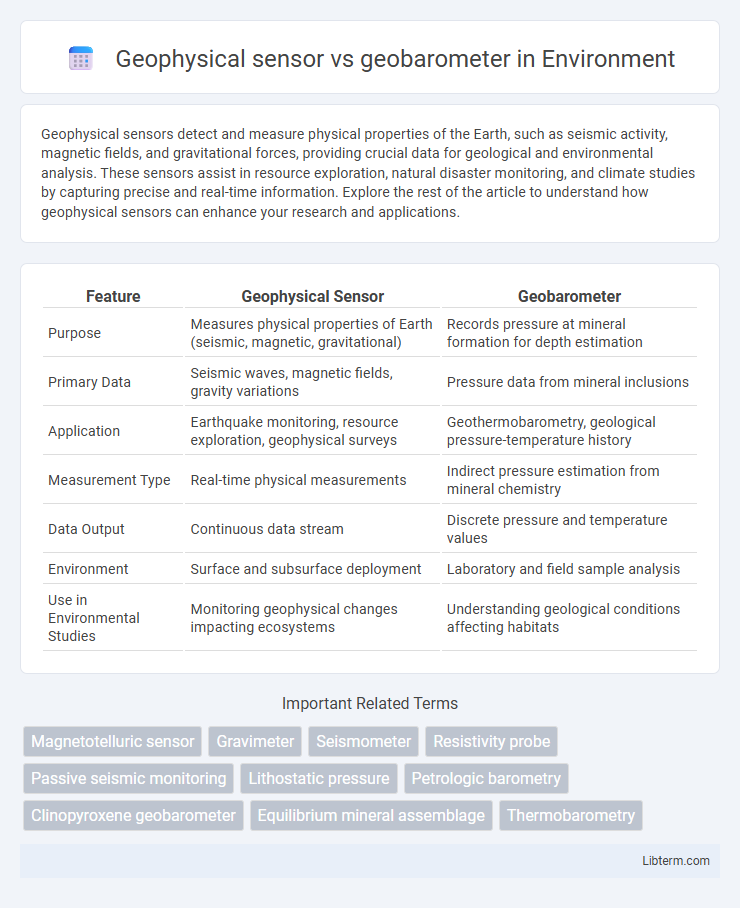
Table of Comparison
| Feature | Geophysical Sensor | Geobarometer |
|---|---|---|
| Purpose | Measures physical properties of Earth (seismic, magnetic, gravitational) | Records pressure at mineral formation for depth estimation |
| Primary Data | Seismic waves, magnetic fields, gravity variations | Pressure data from mineral inclusions |
| Application | Earthquake monitoring, resource exploration, geophysical surveys | Geothermobarometry, geological pressure-temperature history |
| Measurement Type | Real-time physical measurements | Indirect pressure estimation from mineral chemistry |
| Data Output | Continuous data stream | Discrete pressure and temperature values |
| Environment | Surface and subsurface deployment | Laboratory and field sample analysis |
| Use in Environmental Studies | Monitoring geophysical changes impacting ecosystems | Understanding geological conditions affecting habitats |
Introduction to Geophysical Sensors and Geobarometers
Geophysical sensors measure physical properties of the Earth's subsurface such as seismic waves, magnetic fields, and gravitational forces to analyze geological structures and dynamic processes. Geobarometers specifically estimate pressure conditions within rocks by analyzing mineral compositions and phase equilibria, providing critical insights into metamorphic conditions and crustal depth. Both tools are essential in geoscience, with sensors offering broad environmental readings while geobarometers deliver precise pressure measurements at the mineral scale.
Defining Geophysical Sensors
Geophysical sensors are advanced instruments designed to detect and measure physical properties of the Earth, such as seismic activity, magnetic fields, or temperature variations, enabling precise monitoring of geological processes. Unlike geobarometers, which specifically estimate pressure conditions within rocks based on mineral composition, geophysical sensors provide real-time data crucial for understanding dynamic environmental changes. These sensors integrate technologies like accelerometers, magnetometers, and seismometers to support applications in earth sciences, natural disaster prediction, and resource exploration.
Overview of Geobarometers
Geobarometers are specialized instruments designed to measure the pressure conditions within geological formations, providing critical data on the depths and environments where minerals and rocks form. Unlike general geophysical sensors that detect a variety of physical properties such as seismic activity or magnetic fields, geobarometers specifically analyze mineral compositions and phase equilibria to estimate pressure. This precise pressure information is essential for understanding tectonic processes, metamorphic histories, and the evolution of Earth's crust.
Core Principles of Geophysical Sensing
Geophysical sensors rely on detecting physical properties such as seismic waves, magnetic fields, or gravity variations to analyze subsurface structures, utilizing principles like wave propagation and electromagnetic induction. Geobarometers specifically measure pressure conditions within rocks by examining mineral compositions and phase equilibria, based on thermodynamic equilibrium and pressure-dependent mineral stability. Understanding these core principles allows for accurate interpretation of Earth's interior processes, combining geophysical sensing data with geobarometric pressure estimates.
Geobarometer Function and Measurement Techniques
Geobarometers determine the pressure conditions during rock formation by analyzing mineral compositions and phase equilibria, providing crucial insights into metamorphic processes. Techniques such as Raman spectroscopy, electron microprobe analysis, and X-ray diffraction measure changes in crystal lattice parameters that correlate with pressure. These precise measurements allow geobarometers to reconstruct subsurface pressure histories, crucial for understanding tectonic environments and crustal evolution.
Differences in Data Acquisition Methods
Geophysical sensors primarily acquire data by directly measuring physical properties such as seismic waves, magnetic fields, or gravitational variations through in-situ or remote sensing techniques. Geobarometers, in contrast, derive pressure conditions by analyzing mineral compositions and phase equilibria within rock samples using laboratory-based petrological methods. The key difference lies in geophysical sensors capturing real-time physical data, whereas geobarometers interpret geological history through chemical proxies.
Applications in Earth Science Research
Geophysical sensors, such as seismometers and magnetometers, detect physical properties like seismic waves and magnetic fields to study Earth's structure and dynamic processes. Geobarometers measure pressure conditions in rocks by analyzing mineral compositions, providing insights into the depth and environment of rock formation. Both tools complement each other in Earth science research by enabling detailed reconstruction of tectonic activity, metamorphic conditions, and geodynamic evolution.
Advantages and Limitations of Geophysical Sensors
Geophysical sensors offer real-time data collection, high sensitivity to environmental changes, and versatility in monitoring various physical parameters like temperature, pressure, and seismic activity, making them ideal for dynamic Earth studies. Their limitations include susceptibility to noise interference, calibration challenges, and potential data inaccuracies under extreme environmental conditions. Compared to geobarometers, which provide indirect pressure estimates through mineral chemistry, geophysical sensors deliver direct and continuous measurements but may require complex data interpretation and maintenance.
Geobarometer Accuracy and Reliability Factors
Geobarometer accuracy depends heavily on the mineral composition and the pressure calibration curve used, with errors often arising from temperature fluctuations and phase changes during experimentation. Geophysical sensors, while providing real-time pressure data, can encounter reliability issues due to environmental interference and sensor drift over time. The choice between geobarometer and geophysical sensor for precise pressure measurement hinges on balancing the inherent material-based calibration precision against the dynamic, but sometimes less stable, data acquisition capabilities of geophysical sensors.
Choosing Between Geophysical Sensors and Geobarometers
Geophysical sensors provide real-time monitoring of physical properties such as temperature, pressure, and seismic activity, offering versatile applications in environmental and engineering fields. Geobarometers specialize in estimating formation pressures in geological contexts by analyzing mineral compositions and textures within rock samples, enabling precise pressure reconstructions. Selecting between geophysical sensors and geobarometers depends on whether dynamic, continuous data acquisition is required or detailed pressure history from rock records is the primary objective.
Geophysical sensor Infographic