Ground-based sensors play a crucial role in monitoring environmental conditions, tracking weather patterns, and enhancing security systems with precise data collection. These sensors provide real-time information that supports decision-making in agriculture, disaster management, and military operations. Explore the rest of this article to understand how ground-based sensors can improve your data accuracy and operational efficiency.
Table of Comparison
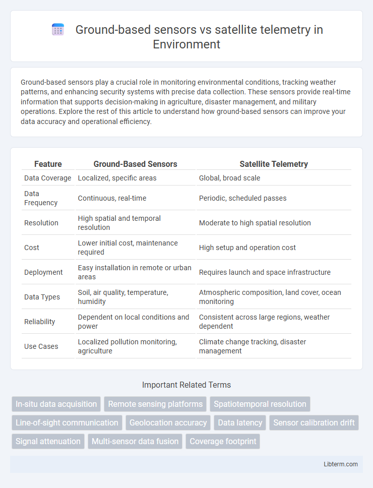
| Feature | Ground-Based Sensors | Satellite Telemetry |
|---|---|---|
| Data Coverage | Localized, specific areas | Global, broad scale |
| Data Frequency | Continuous, real-time | Periodic, scheduled passes |
| Resolution | High spatial and temporal resolution | Moderate to high spatial resolution |
| Cost | Lower initial cost, maintenance required | High setup and operation cost |
| Deployment | Easy installation in remote or urban areas | Requires launch and space infrastructure |
| Data Types | Soil, air quality, temperature, humidity | Atmospheric composition, land cover, ocean monitoring |
| Reliability | Dependent on local conditions and power | Consistent across large regions, weather dependent |
| Use Cases | Localized pollution monitoring, agriculture | Climate change tracking, disaster management |
Introduction to Ground-Based Sensors and Satellite Telemetry
Ground-based sensors provide localized, high-resolution data by directly measuring environmental variables such as temperature, humidity, and seismic activity, enabling detailed monitoring of specific sites. Satellite telemetry offers large-scale, continuous remote sensing capabilities by transmitting observational data from orbiting satellites to ground stations, covering vast geographic areas and enabling real-time analysis. Combining both technologies enhances data accuracy and spatial coverage, essential for applications in climate monitoring, disaster management, and environmental research.
Core Technologies and Working Principles
Ground-based sensors employ localized data acquisition methods such as radar, lidar, and infrared detectors to monitor environmental parameters with high spatial resolution and real-time processing capabilities. Satellite telemetry utilizes onboard instruments like multispectral scanners, Synthetic Aperture Radar (SAR), and radio frequency sensors to collect remote sensing data over extensive geographical areas, transmitting information via communication links to ground stations for analysis. Both technologies rely on electromechanical transducers and signal processing algorithms tailored to their platforms, with ground sensors offering precise temporal tracking and satellites providing broad coverage and multispectral data integration.
Data Accuracy and Resolution Comparison
Ground-based sensors provide higher spatial and temporal resolution data due to their proximity to measurement targets, enabling precise monitoring of localized environmental parameters. Satellite telemetry offers broader coverage with coarser resolution, which can introduce spatial averaging effects but excels in capturing large-scale or remote phenomena. Data accuracy from ground-based sensors is typically higher for specific points, while satellite measurements require calibration and correction algorithms to mitigate atmospheric disturbances and sensor limitations.
Coverage Area: Local vs. Global Monitoring
Ground-based sensors provide precise, high-resolution data focused on localized environmental conditions, ideal for monitoring specific sites or ecosystems. Satellite telemetry offers wide-area coverage capable of global monitoring, enabling continuous observation of large-scale phenomena such as weather patterns, deforestation, and ocean currents. Integrating both technologies enhances environmental monitoring by combining detailed local insights with broad spatial context.
Real-Time Data Availability and Latency
Ground-based sensors provide real-time data with minimal latency due to their proximity to the data source, enabling instant monitoring and rapid decision-making in applications such as environmental tracking and industrial automation. Satellite telemetry, while offering wide-area coverage and access to remote locations, experiences higher latency caused by data transmission delays and satellite orbit cycles, which can impact time-sensitive operations. The choice between ground-based sensors and satellite telemetry depends on the critical need for immediate data availability versus the requirement for expansive spatial coverage.
Installation, Maintenance, and Operational Costs
Ground-based sensors typically involve lower initial installation costs but require frequent maintenance due to environmental exposure and accessibility challenges. Satellite telemetry demands higher upfront expenses for satellite deployment and advanced ground stations, yet it offers reduced maintenance costs with remote operation capabilities. Operational costs for ground-based sensors can escalate over time with manual data retrieval, while satellite systems provide continuous, automated data transmission that streamlines long-term monitoring expenses.
Environmental Impact and Sustainability Considerations
Ground-based sensors minimize environmental disturbance by avoiding the carbon footprint associated with satellite launches and operation, offering localized, continuous monitoring of ecosystems with high spatial resolution. Satellite telemetry provides extensive geographic coverage essential for tracking large-scale environmental changes, but its reliance on rocket launches contributes to atmospheric pollution and space debris. Sustainable environmental monitoring combines ground-based sensor networks with satellite data to optimize real-time observations while reducing ecological impact and supporting long-term resource management.
Application Domains and Use Cases
Ground-based sensors excel in environmental monitoring and precision agriculture by providing high-resolution, real-time data on soil moisture, temperature, and crop health within localized areas. Satellite telemetry offers expansive coverage for applications like global climate monitoring, disaster management, and wildlife tracking, enabling data collection over remote or inaccessible regions. Integrating ground-based sensors with satellite telemetry enhances accuracy and spatial resolution in domains such as weather forecasting, ecosystem studies, and resource management.
Integration and Interoperability with Other Systems
Ground-based sensors offer real-time, high-resolution data critical for local monitoring, while satellite telemetry provides extensive spatial coverage for regional and global analysis. Integrating these two systems enhances interoperability by combining precise ground-level measurements with broad satellite observations, facilitating comprehensive environmental monitoring and decision-making. Seamless data fusion ensures synchronized operation across platforms, optimizing the accuracy and reliability of multi-source information systems.
Future Trends and Innovations in Monitoring Technologies
Future trends in monitoring technologies highlight advancements in ground-based sensors with enhanced AI-driven data analysis, enabling real-time environmental and structural health insights. Satellite telemetry innovations focus on higher-resolution imaging and expanded sensor payloads, facilitating global-scale monitoring with improved accuracy and frequency. Integration of ground-based and satellite data through IoT and cloud platforms drives predictive analytics and autonomous decision-making in sectors like agriculture, climate science, and disaster management.
Ground-based sensors Infographic