Ice sheets are massive layers of glacial ice covering extensive land areas, primarily found in Antarctica and Greenland. They play a crucial role in Earth's climate system by regulating sea levels and reflecting solar radiation. Explore the article to understand how ice sheets impact global environments and what their changes mean for your future.
Table of Comparison
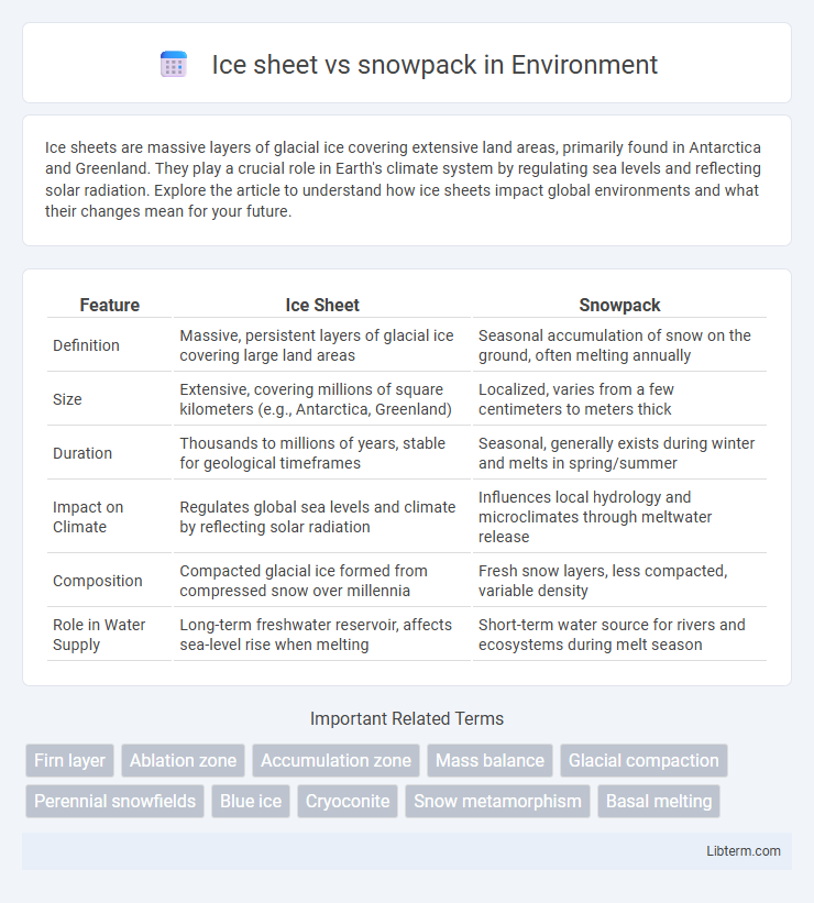
| Feature | Ice Sheet | Snowpack |
|---|---|---|
| Definition | Massive, persistent layers of glacial ice covering large land areas | Seasonal accumulation of snow on the ground, often melting annually |
| Size | Extensive, covering millions of square kilometers (e.g., Antarctica, Greenland) | Localized, varies from a few centimeters to meters thick |
| Duration | Thousands to millions of years, stable for geological timeframes | Seasonal, generally exists during winter and melts in spring/summer |
| Impact on Climate | Regulates global sea levels and climate by reflecting solar radiation | Influences local hydrology and microclimates through meltwater release |
| Composition | Compacted glacial ice formed from compressed snow over millennia | Fresh snow layers, less compacted, variable density |
| Role in Water Supply | Long-term freshwater reservoir, affects sea-level rise when melting | Short-term water source for rivers and ecosystems during melt season |
Introduction to Ice Sheets and Snowpacks
Ice sheets are massive, continent-sized glacial formations primarily found in Greenland and Antarctica, containing vast amounts of frozen freshwater that influence global sea levels and climate patterns. Snowpacks consist of seasonal layers of compacted snow that accumulate in mountainous and polar regions, serving as crucial freshwater reservoirs and affecting regional hydrology and ecosystems. Understanding the differences in scale, formation, and environmental impact between ice sheets and snowpacks is essential for studying climate change and water resource management.
Defining Ice Sheets: Characteristics and Formation
Ice sheets are massive, continent-sized layers of glacial ice covering over 50,000 square kilometers, primarily found in Antarctica and Greenland. These ice formations result from centuries of accumulated snowfall compacted under immense pressure, transforming into dense, solid ice that flows slowly over land. Unlike seasonal snowpack, which accumulates and melts annually, ice sheets persist through time and significantly impact global sea levels and climate patterns.
Understanding Snowpacks: Structure and Development
Snowpacks consist of layered accumulations of snow crystals that undergo continuous metamorphosis influenced by temperature gradients, moisture, and wind, shaping their density and stability. Ice sheets are massive, thick accumulations of perennial ice formed over millennia through compaction and recrystallization of snowpack layers, primarily found in polar regions like Greenland and Antarctica. Understanding snowpack development involves analyzing its stratigraphy, crystal types, and melt-freeze cycles that impact avalanche risk and water resource forecasting.
Geographic Distribution: Where Ice Sheets and Snowpacks Occur
Ice sheets primarily cover vast polar regions such as Antarctica and Greenland, encompassing millions of square kilometers and containing the majority of the Earth's freshwater ice. Snowpacks are more geographically diverse, forming seasonally in mountainous areas like the Rockies, Alps, and Himalayas, as well as temperate zones where winter snowfall accumulates on the ground. The distribution of ice sheets is largely limited to high-latitude land masses, whereas snowpacks appear in both polar and mid-latitude regions with sufficient cold temperatures and precipitation.
Thickness and Size: Comparing Ice Sheets to Snowpacks
Ice sheets, such as those in Antarctica and Greenland, can reach thicknesses of up to several kilometers and cover areas spanning millions of square kilometers, making them among the largest and thickest bodies of ice on Earth. In contrast, snowpacks typically range from a few centimeters to several meters in thickness and only cover localized regions, often in high-altitude or polar environments during winter seasons. The immense size and thickness of ice sheets significantly impact global sea levels and climate patterns, whereas snowpacks primarily influence local hydrology and seasonal water supply.
Seasonal vs. Permanent Features
Ice sheets are massive, permanent features of the Earth's cryosphere, covering extensive land areas like Antarctica and Greenland with thick layers of ice that persist year-round. Snowpacks are seasonal accumulations of snow that form during colder months and melt completely during warmer seasons, mainly affecting mountainous or temperate regions. The distinction lies in the temporal stability where ice sheets contribute to long-term climate regulation, while snowpacks influence short-term hydrological cycles and water resources.
Role in the Global Climate System
Ice sheets, vast masses of glacial land ice covering Greenland and Antarctica, play a critical role in regulating Earth's climate by influencing sea levels and reflecting solar radiation due to their high albedo. Snowpacks, seasonal accumulations of snow primarily in mountainous regions, act as natural reservoirs that store freshwater and affect regional climate patterns through their impact on surface energy balance and hydrology. Both ice sheets and snowpacks contribute to the global climate system by modulating temperature, driving ocean circulation, and controlling freshwater input to marine environments.
Ice Sheet and Snowpack Impact on Sea Level
Ice sheets, such as those in Greenland and Antarctica, contain vast amounts of freshwater and their melting significantly contributes to global sea level rise due to the direct transfer of ice mass into the ocean. Snowpacks, primarily seasonal accumulations in mountainous regions, primarily influence sea level through freshwater runoff but have a much smaller impact compared to the colossal ice sheets. Understanding the melting rates of ice sheets versus the seasonal variability of snowpack is crucial for accurate predictions of future sea level rise and coastal impact assessments.
Monitoring and Research Techniques
Ice sheet monitoring relies on satellite remote sensing technologies such as radar altimetry and gravimetry to track changes in mass balance and surface elevation over vast polar regions. Snowpack research employs ground-based instruments including snow pillows, snow depth sensors, and infrared cameras to measure snow water equivalent, accumulation rates, and temperature profiles in mountainous and temperate environments. Combining airborne LiDAR surveys with climate modeling enhances the understanding of both ice sheet dynamics and seasonal snowpack variability under changing climatic conditions.
Future Trends: Climate Change Effects on Ice Sheets and Snowpacks
Rising global temperatures accelerate the melting of ice sheets in Greenland and Antarctica, contributing significantly to sea level rise and altering global ocean currents. Mountain snowpacks are experiencing reduced accumulation and earlier melt seasons, impacting freshwater availability for millions of people dependent on seasonal runoff. Climate models predict intensified feedback loops, where diminishing snowpacks and shrinking ice sheets amplify regional warming, further destabilizing these critical cryospheric components.
Ice sheet Infographic