Erosion patterns reveal how natural forces like wind, water, and ice shape landscapes over time, creating distinctive formations and altering ecosystems. Understanding these patterns helps predict soil loss, manage land use, and protect your property from damage. Explore the rest of the article to learn how erosion impacts the environment and what measures you can take to mitigate its effects.
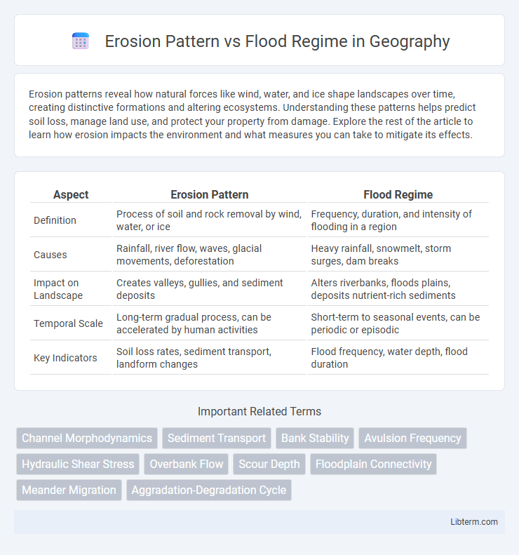
Table of Comparison
| Aspect | Erosion Pattern | Flood Regime |
|---|---|---|
| Definition | Process of soil and rock removal by wind, water, or ice | Frequency, duration, and intensity of flooding in a region |
| Causes | Rainfall, river flow, waves, glacial movements, deforestation | Heavy rainfall, snowmelt, storm surges, dam breaks |
| Impact on Landscape | Creates valleys, gullies, and sediment deposits | Alters riverbanks, floods plains, deposits nutrient-rich sediments |
| Temporal Scale | Long-term gradual process, can be accelerated by human activities | Short-term to seasonal events, can be periodic or episodic |
| Key Indicators | Soil loss rates, sediment transport, landform changes | Flood frequency, water depth, flood duration |
Introduction to Erosion Patterns and Flood Regimes
Erosion patterns describe the spatial and temporal distribution of soil and sediment displacement driven by natural forces such as water flow, wind, and ice movement. Flood regimes encompass the frequency, duration, intensity, and timing of flood events within a specific river basin or watershed, critically influencing landscape dynamics and ecosystem processes. Understanding the interplay between erosion patterns and flood regimes is essential for effective watershed management, soil conservation, and flood risk mitigation.
Defining Erosion Patterns: Types and Processes
Erosion patterns are characterized by distinct types such as sheet, rill, gully, and streambank erosion, each driven by specific hydrological and geological processes. Sheet erosion involves the uniform removal of soil layers, while rill and gully erosion result from concentrated water flow creating small channels and deep trenches, respectively. Flood regimes influence these erosion types by altering water velocity, sediment load, and frequency of inundation, thereby shaping the landscape through dynamic and varied erosional forces.
Flood Regimes: Classification and Characteristics
Flood regimes are classified based on frequency, magnitude, duration, and timing, with typical categories including flash floods, riverine floods, and coastal floods. Each regime exhibits distinct hydrological characteristics impacting erosion patterns differently, where flash floods cause rapid sediment displacement while riverine floods lead to prolonged inundation and sediment deposition. Understanding these flood regime classifications helps predict erosion processes and informs effective flood risk management strategies.
Interrelationship Between Erosion and Flood Dynamics
Erosion patterns significantly influence flood regimes by altering riverbank stability and sediment transport, which in turn affect flood frequency and intensity. Changes in erosion rates reshape floodplains, impacting water flow pathways and increasing the likelihood of severe flooding events. Understanding the interrelationship between erosion and flood dynamics is essential for effective watershed management and mitigating flood risks.
Factors Influencing Erosion Patterns in Flood-Prone Areas
Soil composition, vegetation cover, and rainfall intensity significantly influence erosion patterns in flood-prone areas, determining the rate and extent of sediment displacement. Riverbank stability is affected by flood regime characteristics such as peak discharge and duration, which shape channel morphology and sediment transport processes. Human activities like deforestation and urban development exacerbate erosion by disrupting natural water flow and reducing soil permeability.
Impact of Flood Regimes on Soil and Landscape Erosion
Flood regimes significantly influence soil and landscape erosion by dictating water flow intensity and duration, which control sediment displacement and deposition patterns. Intense, frequent flooding increases surface runoff velocity, leading to accelerated soil erosion and alteration of natural erosion patterns across floodplains and riverbanks. Variations in flood frequency and magnitude directly affect the erosion rate, sediment transport, and reshaping of topography in affected ecosystems.
Case Studies: Erosion Patterns in Diverse Flood Regimes
Case studies analyzing erosion patterns in diverse flood regimes reveal significant variations in soil loss and sediment transport influenced by flood intensity, duration, and frequency. In tropical river basins, high-magnitude floods cause rapid channel incision and bank collapse, while in temperate zones, seasonal flooding leads to gradual lateral erosion and floodplain development. Understanding these distinct erosion behaviors aids in predicting landscape evolution and informs flood management strategies tailored to specific hydrological and geological settings.
Tools and Techniques for Monitoring Erosion and Flooding
Remote sensing technologies, such as LiDAR and satellite imagery, provide precise data for monitoring erosion patterns and flood regimes by capturing topographical changes and water flow dynamics. Geographic Information Systems (GIS) facilitate the integration and analysis of spatial data, enabling accurate mapping and prediction of erosion hotspots and flood-prone areas. Sensor networks and drones further enhance real-time monitoring capabilities, offering detailed insights into soil displacement, sediment transport, and hydrological shifts critical for mitigating environmental impacts.
Mitigation Strategies: Managing Erosion Under Changing Flood Regimes
Effective mitigation strategies for managing erosion under changing flood regimes incorporate the use of riparian buffer zones, engineered flood barriers, and sustainable land-use planning to stabilize soil and reduce sediment runoff. Adaptive management involves continuous monitoring of erosion patterns alongside flood frequency and intensity data to optimize intervention timing and placement. Integrating these approaches enhances ecosystem resilience and minimizes infrastructure damage in flood-prone areas.
Future Trends: Predicting Erosion in a Changing Climate
Future trends in erosion patterns are closely tied to evolving flood regimes influenced by climate change. Increased rainfall intensity and variability lead to more frequent and severe flooding events, accelerating soil erosion rates and altering sediment transport dynamics. Advanced predictive models integrating hydrological data and climate projections are essential for accurately forecasting erosion hotspots and guiding adaptive land management strategies.
Erosion Pattern Infographic