Precipitation patterns significantly influence ecosystems and human activities by determining water availability and seasonal weather trends. Understanding these patterns helps you prepare for shifts in rainfall intensity and distribution that impact agriculture, urban planning, and water resource management. Explore the rest of the article to learn how precipitation patterns shape environmental and economic outcomes.
Table of Comparison
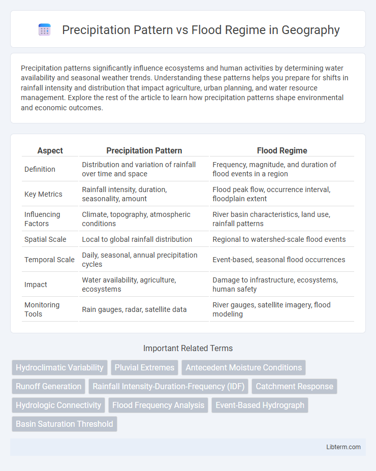
| Aspect | Precipitation Pattern | Flood Regime |
|---|---|---|
| Definition | Distribution and variation of rainfall over time and space | Frequency, magnitude, and duration of flood events in a region |
| Key Metrics | Rainfall intensity, duration, seasonality, amount | Flood peak flow, occurrence interval, floodplain extent |
| Influencing Factors | Climate, topography, atmospheric conditions | River basin characteristics, land use, rainfall patterns |
| Spatial Scale | Local to global rainfall distribution | Regional to watershed-scale flood events |
| Temporal Scale | Daily, seasonal, annual precipitation cycles | Event-based, seasonal flood occurrences |
| Impact | Water availability, agriculture, ecosystems | Damage to infrastructure, ecosystems, human safety |
| Monitoring Tools | Rain gauges, radar, satellite data | River gauges, satellite imagery, flood modeling |
Introduction to Precipitation Patterns and Flood Regimes
Precipitation patterns refer to the spatial and temporal distribution of rainfall, snowfall, or other forms of moisture in a specific region, influencing water availability and ecosystem dynamics. Flood regimes describe the frequency, magnitude, duration, and timing of flood events, shaped by both natural hydrological processes and precipitation variability. Understanding the interaction between precipitation patterns and flood regimes is essential for effective water resource management, disaster risk reduction, and climate change adaptation strategies.
Key Differences Between Precipitation Patterns and Flood Regimes
Precipitation patterns refer to the spatial and temporal distribution of rainfall or snowfall over a region, while flood regimes describe the frequency, duration, and magnitude of flood events in a specific area. The primary difference lies in precipitation patterns being a climatic variable influencing hydrological inputs, whereas flood regimes characterize the resultant hydrological response and inundation dynamics within a watershed. Understanding these distinctions is crucial for effective water resource management and flood risk mitigation strategies.
How Precipitation Patterns Influence Flooding Events
Precipitation patterns, including the intensity, duration, and frequency of rainfall, directly influence flood regimes by determining the volume of runoff and soil saturation levels in a watershed. Intense, short-duration storms often lead to flash floods due to rapid surface runoff, while prolonged precipitation increases river discharge, causing riverine floods. Variations in seasonal precipitation affect flood timing and magnitude, impacting floodplain dynamics and water management strategies.
Types of Precipitation and Their Flood Impacts
Convective precipitation often causes intense, short-duration rainfall leading to flash floods, while stratiform precipitation typically results in prolonged, moderate rainfall that can trigger riverine floods. Orographic precipitation, enhanced by mountainous terrain, increases flood risk in downstream areas due to sustained water input. Mixed precipitation types create complex flood regimes where rapid runoff and saturated soils combine to exacerbate flooding severity.
Regional Variations in Precipitation-Flood Relationships
Regional variations in precipitation-flood relationships are influenced by factors such as topography, soil type, and urbanization levels, which alter runoff and infiltration rates. Mountainous regions often experience rapid runoff leading to flash floods, while flat plains may face prolonged flooding due to slower water drainage. Understanding these spatial differences is crucial for accurate flood risk assessment and implementation of localized flood management strategies.
Climate Change Effects on Precipitation and Flood Regimes
Climate change intensifies precipitation patterns, leading to more frequent and severe rainfall events that alter flood regimes globally. Increased atmospheric moisture and altered weather systems result in unpredictable runoff volumes and peak flow timings, exacerbating flood risks. These shifts impact infrastructure resilience, water resource management, and ecological stability in flood-prone regions.
Modeling Precipitation Patterns for Flood Prediction
Modeling precipitation patterns leverages meteorological data and hydrological simulations to predict flood regimes accurately by analyzing rainfall intensity, duration, and spatial distribution. Advanced techniques such as machine learning and remote sensing improve the precision of flood forecasts by capturing complex rainfall variability and identifying potential flood-prone areas. Integrating these models into flood management systems enhances early warning capabilities and disaster preparedness.
Case Studies: Notable Flood Events Linked to Precipitation Changes
Intensified precipitation patterns have been directly linked to notable flood events such as the 2010 Pakistan floods, where unprecedented monsoon rainfall caused extensive river overflow and urban inundation. Case studies from the Mississippi River Basin demonstrate how shifts in seasonal precipitation magnitude and distribution alter flood regimes, leading to increased frequency and severity of floods. Research in the Yangtze River Delta highlights correlations between typhoon-induced extreme rainfall and subsequent flood peaks, emphasizing the critical role of changing precipitation dynamics in flood risk management.
Strategies for Managing Flood Risk Amid Shifting Precipitation Patterns
Adapting flood risk management strategies requires integrating detailed analysis of changing precipitation patterns with flood regime characteristics. Implementing advanced hydrological models, real-time monitoring systems, and resilient infrastructure enhances preparedness for variable rainfall intensity and duration. Emphasizing natural flood management techniques such as wetlands restoration and sustainable land use complements engineered solutions to mitigate flood impacts effectively.
Future Directions in Research on Precipitation Patterns and Flood Regimes
Future research on precipitation patterns and flood regimes prioritizes advanced climate modeling to predict extreme weather events with higher accuracy. Integration of high-resolution satellite data and machine learning algorithms enhances understanding of spatial and temporal variations in precipitation and flood risks. Improved interdisciplinary approaches combining hydrology, meteorology, and urban planning aim to develop adaptive flood management strategies under changing climate scenarios.
Precipitation Pattern Infographic