A datum serves as a foundational reference point in mapping and geospatial measurements, ensuring accurate positioning and data consistency. Understanding how datums function is essential for applications in surveying, navigation, and geographic information systems. Explore the rest of the article to discover how choosing the right datum impacts the precision of your spatial data.
Table of Comparison
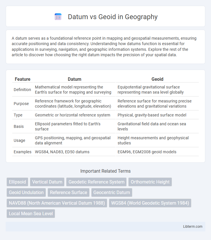
| Feature | Datum | Geoid |
|---|---|---|
| Definition | Mathematical model representing the Earth's surface for mapping and surveying | Equipotential gravitational surface representing mean sea level globally |
| Purpose | Reference framework for geographic coordinates (latitude, longitude, elevation) | Reference surface for measuring precise elevations and gravitational variations |
| Type | Geometric or horizontal reference system | Physical, gravity-based surface model |
| Basis | Ellipsoid parameters fitted to Earth's surface | Gravitational field data and ocean sea levels |
| Usage | GPS positioning, mapping, and geospatial data alignment | Height measurements and geophysical studies |
| Examples | WGS84, NAD83, ED50 datums | EGM96, EGM2008 geoid models |
Introduction to Datum and Geoid
A datum is a reference framework comprising a set of coordinates and measurements used to precisely locate geographic positions on Earth's surface, essential for mapping and navigation. The geoid represents the hypothetical sea level surface of the Earth, reflecting variations in gravitational fields and serving as a key vertical datum to measure elevations. Understanding the distinction between datum and geoid ensures accurate geospatial data interpretation in surveying, GPS, and geodesy.
Definitions: What Is a Datum?
A datum is a reference framework consisting of a set of points on the Earth's surface against which position measurements are made, providing a base for geographic coordinate systems. It defines the origin and orientation of latitude, longitude, and elevation, enabling accurate mapping and navigation. Unlike the geoid, which represents mean sea level as an equipotential gravitational surface, a datum serves as a mathematical model for locating points in three-dimensional space.
Understanding the Geoid
The geoid represents the Earth's mean sea level extended continuously beneath the continents, serving as a reference surface for measuring elevations and gravitational potential. Unlike a datum, which is a mathematically defined surface based on an ellipsoid model, the geoid accounts for variations in Earth's gravity caused by density differences within its interior. Understanding the geoid is essential for precise geodetic measurements, satellite navigation, and accurate mapping of Earth's topography.
Key Differences Between Datum and Geoid
A datum is a reference framework used for measuring locations on the Earth's surface, defining latitude, longitude, and elevation based on a mathematical model like an ellipsoid. The geoid represents the Earth's mean sea level expanded under continents, providing a surface of equal gravitational potential crucial for accurate elevation measurements. Key differences include the datum's role in horizontal and vertical positioning with a reference ellipsoid, while the geoid defines the true vertical reference based on gravitational variations.
How a Datum Is Constructed
A datum is constructed by selecting a reference ellipsoid that approximates the shape of the Earth and defining fixed control points with known coordinates on the Earth's surface. These control points establish the position, orientation, and origin of the ellipsoid relative to the Earth, enabling consistent geospatial measurements. Unlike a geoid, which represents mean sea level and gravitational equipotential, a datum provides a mathematical framework for mapping and surveying.
The Science Behind the Geoid Model
The geoid model represents Earth's mean sea level shaped by gravitational variations, providing a precise reference surface for measuring elevations and ocean circulation. Unlike a datum, which is a mathematically defined reference frame for mapping and surveying, the geoid accounts for complex mass distribution within Earth's interior affecting gravity. Advanced satellite missions like GRACE and GOCE supply crucial gravity data to refine geoid models, enhancing accuracy in geodesy and Earth sciences.
Applications of Datum in Mapping and GIS
Datums serve as foundational reference models for accurately locating geographic features on Earth's surface, essential for precise mapping and Geographic Information Systems (GIS). They provide a consistent frame of reference for coordinate systems, enabling integration and analysis of spatial data across diverse applications such as urban planning, navigation, and environmental monitoring. Unlike the geoid, which models Earth's mean sea level for elevation measurements, datums establish horizontal and vertical positioning critical for geospatial data consistency and interoperability in mapping workflows.
Importance of the Geoid in Elevation Measurement
The geoid serves as the true physical reference surface representing mean sea level, critical for accurate elevation measurement and mapping. Unlike a simple ellipsoidal datum, the geoid accounts for variations in Earth's gravitational field, providing a more precise vertical datum for surveying and geodesy. Elevation data relative to the geoid ensures consistency in construction, navigation, and flood risk management, where precise height information is essential.
Challenges in Integrating Datum and Geoid
Integrating datum and geoid presents challenges due to their differing reference surfaces: datums often rely on ellipsoidal models, while geoids represent mean sea level influenced by gravitational variations. Aligning these models requires precise gravitational data and advanced computational methods to accurately transform coordinate systems across varying local geoid undulations. Variability in regional geoid models and datum definitions complicates worldwide standardization and consistent elevation measurements.
Future Developments in Geodetic Reference Systems
Advancements in geodetic reference systems aim to integrate high-precision satellite data and gravity field models to refine the definition of datums and geoids. Future developments will emphasize the fusion of global navigation satellite system (GNSS) measurements with real-time gravimetric data to achieve centimeter-level accuracy in geoid determination. Enhanced computational algorithms and continuous observations are expected to support dynamic and time-dependent reference frames, improving spatial data accuracy for applications in earth sciences, navigation, and surveying.
Datum Infographic