Cartography involves the art and science of mapmaking, integrating geographic data to create visual representations of Earth's surfaces and spatial relationships. It employs various techniques and technologies, including GIS and remote sensing, to enhance accuracy and usability for navigation, urban planning, and environmental management. Explore the rest of the article to understand how cartography shapes your interaction with the world.
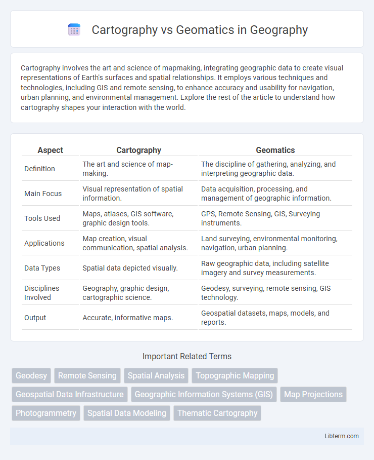
Table of Comparison
| Aspect | Cartography | Geomatics |
|---|---|---|
| Definition | The art and science of map-making. | The discipline of gathering, analyzing, and interpreting geographic data. |
| Main Focus | Visual representation of spatial information. | Data acquisition, processing, and management of geographic information. |
| Tools Used | Maps, atlases, GIS software, graphic design tools. | GPS, Remote Sensing, GIS, Surveying instruments. |
| Applications | Map creation, visual communication, spatial analysis. | Land surveying, environmental monitoring, navigation, urban planning. |
| Data Types | Spatial data depicted visually. | Raw geographic data, including satellite imagery and survey measurements. |
| Disciplines Involved | Geography, graphic design, cartographic science. | Geodesy, surveying, remote sensing, GIS technology. |
| Output | Accurate, informative maps. | Geospatial datasets, maps, models, and reports. |
Introduction to Cartography and Geomatics
Cartography involves the art and science of creating maps, emphasizing spatial data visualization and geographic representation techniques. Geomatics encompasses a broader field integrating cartography, geographic information systems (GIS), remote sensing, and surveying for comprehensive spatial data acquisition, analysis, and management. Both disciplines play crucial roles in spatial data interpretation, with cartography focused on map design and geomatics on data capture and processing.
Defining Cartography: Scope and Applications
Cartography is the science and art of creating maps that visually represent spatial data, focusing on the design, production, and interpretation of geographic information. Its applications span urban planning, environmental monitoring, navigation, and resource management by providing clear, accurate visualizations of complex spatial relationships. Unlike geomatics, which integrates a broader range of geographic data acquisition and analysis technologies, cartography specializes in transforming geographic data into effective visual communication tools.
Understanding Geomatics: Key Concepts
Geomatics integrates various technologies such as Geographic Information Systems (GIS), remote sensing, and Global Navigation Satellite Systems (GNSS) to collect, analyze, and manage spatial data. Unlike traditional cartography that focuses primarily on map-making, geomatics encompasses data acquisition, processing, and interpretation for diverse applications including urban planning, environmental monitoring, and resource management. Mastering geomatics involves understanding spatial data models, coordinate systems, and geospatial analysis techniques essential for accurate decision-making and problem-solving.
Historical Evolution of Cartography and Geomatics
The historical evolution of cartography dates back to ancient civilizations, where maps were hand-drawn to represent geographical features for navigation and territorial claims. Geomatics emerged in the mid-20th century, integrating advances in Geographic Information Systems (GIS), remote sensing, and global positioning systems (GPS) to enhance spatial data collection, management, and analysis. The transition from traditional cartographic methods to geomatics reflects the technological shift toward digital mapping, enabling precise, real-time geospatial information critical for modern applications.
Core Differences Between Cartography and Geomatics
Cartography centers on the art and science of map-making, emphasizing visual representation and spatial communication of geographic information. Geomatics encompasses a broader field, integrating data acquisition, analysis, and management through technologies like GPS, GIS, and remote sensing. The core difference lies in cartography's focus on designing and interpreting maps, whereas geomatics involves the collection and processing of spatial data for various applications.
Overlapping Areas and Interdisciplinary Links
Cartography and Geomatics intersect primarily in spatial data collection, analysis, and visualization, where both fields leverage geographic information systems (GIS) to create accurate and detailed maps. The interdisciplinary links involve remote sensing, spatial data management, and geospatial analysis techniques essential for environmental monitoring, urban planning, and resource management. Advances in digital mapping technologies and data integration platforms further blur the lines between cartography's traditional focus on map design and geomatics' comprehensive approach to geospatial information systems.
Tools and Technologies Used in Cartography vs. Geomatics
Cartography primarily relies on traditional tools such as compasses, protractors, and paper maps, evolving towards Geographic Information Systems (GIS) and digital mapping software like ArcGIS and QGIS for spatial data visualization. Geomatics integrates advanced technologies including Global Positioning System (GPS), remote sensing satellites, LiDAR, and drone-based surveying systems to capture, analyze, and interpret geospatial information in real-time. Both disciplines use spatial databases and analytical software, but geomatics emphasizes data acquisition and processing technologies, whereas cartography concentrates on map design and communication.
Educational and Career Pathways
Cartography education emphasizes map design, spatial data visualization, and geographic information system (GIS) software proficiency, preparing students for careers as mapmakers, GIS analysts, or spatial data specialists. Geomatics programs cover broader topics including remote sensing, surveying, geodesy, and data acquisition, equipping graduates for roles in land surveying, geospatial engineering, and environmental monitoring. Both fields demand strong skills in geospatial technology, but geomatics offers a more technical and engineering-oriented career trajectory, while cartography focuses on artistic and analytical aspects of spatial data representation.
Real-world Applications and Industry Relevance
Cartography specializes in the visual representation and interpretation of geographic data, critical for urban planning, navigation, and environmental monitoring. Geomatics integrates advanced technologies like GPS, remote sensing, and GIS to collect, analyze, and manage spatial information, supporting industries such as agriculture, construction, and disaster management. The synergy of cartography's map-making precision with geomatics' data acquisition and analysis drives innovation in location-based services and geospatial decision-making.
Future Trends in Cartography and Geomatics
Future trends in cartography emphasize the integration of augmented reality and real-time data visualization to enhance spatial awareness and user interaction. Geomatics is advancing through AI-driven data analytics and enhanced remote sensing technologies, enabling more precise environmental monitoring and resource management. Both fields increasingly rely on cloud computing and IoT connectivity to facilitate seamless data sharing and collaborative mapping solutions worldwide.
Cartography Infographic