Slope measures the steepness or incline of a surface, often represented as the ratio of vertical change to horizontal change. It plays a crucial role in fields like mathematics, engineering, and geography for analyzing terrain, road design, and data trends. Explore the rest of the article to understand how slope impacts various real-world applications and how you can calculate it accurately.
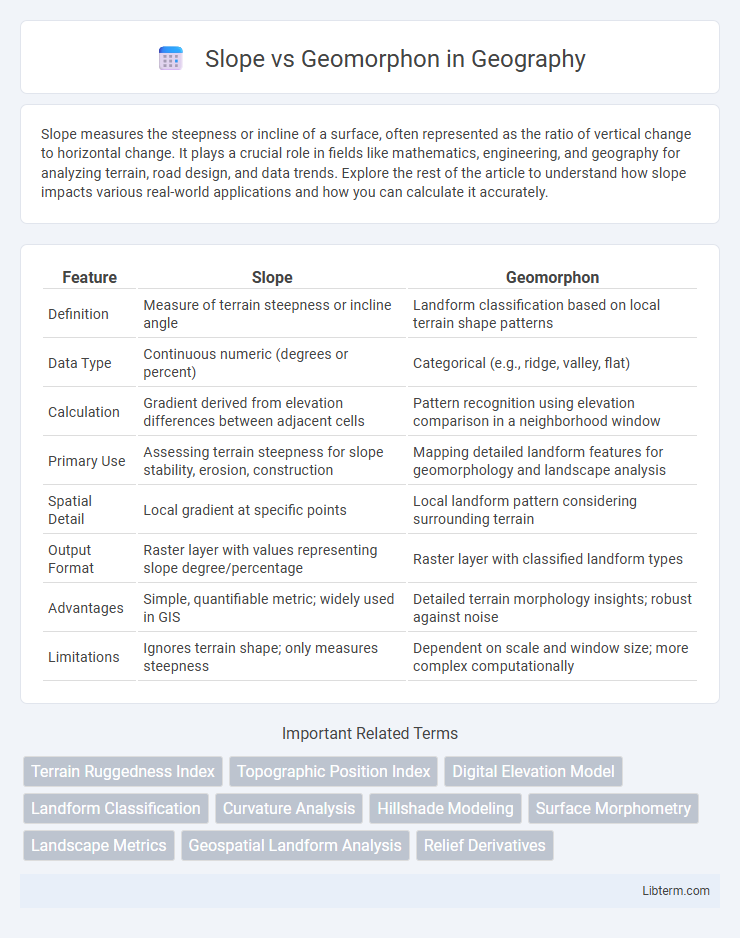
Table of Comparison
| Feature | Slope | Geomorphon |
|---|---|---|
| Definition | Measure of terrain steepness or incline angle | Landform classification based on local terrain shape patterns |
| Data Type | Continuous numeric (degrees or percent) | Categorical (e.g., ridge, valley, flat) |
| Calculation | Gradient derived from elevation differences between adjacent cells | Pattern recognition using elevation comparison in a neighborhood window |
| Primary Use | Assessing terrain steepness for slope stability, erosion, construction | Mapping detailed landform features for geomorphology and landscape analysis |
| Spatial Detail | Local gradient at specific points | Local landform pattern considering surrounding terrain |
| Output Format | Raster layer with values representing slope degree/percentage | Raster layer with classified landform types |
| Advantages | Simple, quantifiable metric; widely used in GIS | Detailed terrain morphology insights; robust against noise |
| Limitations | Ignores terrain shape; only measures steepness | Dependent on scale and window size; more complex computationally |
Introduction to Slope and Geomorphon
Slope measures the steepness or incline of a terrain surface, representing the rate of elevation change over a specified distance, which is crucial for hydrological modeling, erosion prediction, and land suitability analysis. Geomorphon identifies landform patterns by classifying terrain features into morphological elements such as ridges, valleys, and flat areas based on digital elevation models, enabling detailed landscape characterization and terrain segmentation. Understanding both slope and geomorphon enhances terrain analysis accuracy by combining quantitative gradient assessment with qualitative morphological classification.
Defining Slope in Geomorphology
Slope in geomorphology refers to the angle or steepness of a land surface, crucial for understanding erosion, sediment transport, and landscape evolution. Geomorphons are landform classification units derived from topographic data that capture local shape patterns, including slope characteristics. Defining slope within geomorphons involves quantifying gradient changes across terrain to distinguish morphological features such as ridges, valleys, and flat surfaces with precision.
Understanding Geomorphon Concept
Geomorphons represent landforms by classifying terrain based on shape patterns rather than just slope gradient, capturing features like ridges, valleys, and flat areas through local neighborhood analysis. This method provides a more detailed understanding of landform morphology by identifying recurring geomorphic patterns, which slope measurements alone cannot distinguish. By emphasizing terrain form recognition over simple incline, geomorphons enable enhanced geomorphological mapping and landscape analysis.
Data Requirements for Slope and Geomorphon Analysis
Slope analysis requires high-resolution digital elevation models (DEMs) with precise elevation data to accurately calculate gradient and aspect, typically needing spatial resolutions of 10 meters or finer for detailed terrain assessment. Geomorphon analysis demands DEMs with consistent vertical accuracy but can tolerate moderate spatial resolutions around 30 meters, as it classifies terrain forms by pattern recognition of local elevation variations rather than exact slope measurements. Both methods benefit from pre-processed DEMs free of noise and artifacts, yet slope analysis is more sensitive to elevation errors, influencing gradient precision and hydrological modeling outcomes.
Methodologies: Slope Calculation Techniques
Slope calculation techniques utilize digital elevation models (DEMs) to quantify terrain steepness by analyzing the rate of elevation change between adjacent cells, often applying algorithms such as Horn's method or the maximum slope method for precise gradient determination. Geomorphon classification employs pattern recognition within neighborhoods of DEMs to identify landform types based on local slope, aspect, and curvature, leveraging templates that distinguish features like ridges, valleys, and flat areas without directly computing slope angles. While slope focuses on numerical gradient extraction essential for hydrological modelling and erosion assessment, geomorphons emphasize morphometric shape categorization to inform geomorphological mapping and landscape evolution studies.
Geomorphon Classification Algorithms
Geomorphon classification algorithms analyze terrain morphology by identifying local landform patterns based on elevation data, providing detailed insights into landscape features beyond simple slope measurements. These algorithms classify geomorphic forms such as ridges, valleys, and flats by comparing elevation profiles in specified search radii, enabling precise terrain categorization for geospatial analysis. Unlike slope calculation, which measures gradient magnitude, geomorphon methods capture complex landform shapes, enhancing terrain characterization in applications like geomorphology, hydrology, and environmental modeling.
Comparative Analysis: Slope vs Geomorphon
Slope measures the steepness or incline of terrain, providing quantitative data on gradient intensity crucial for hydrological modeling, erosion assessment, and landform classification. Geomorphon identifies specific landform patterns like ridges, valleys, and flats by analyzing local terrain morphology, offering qualitative insights into landscape features beyond simple incline. Comparing slope and geomorphon reveals that while slope excels in detecting gradient magnitude necessary for engineering applications, geomorphon provides detailed morphometric classification essential for geomorphological mapping and ecological studies.
Applications in Environmental and Terrain Studies
Slope analysis quantifies the degree of steepness in terrain, essential for soil erosion prediction, flood risk assessment, and land-use planning in environmental studies. Geomorphon classification identifies landform patterns such as ridges, valleys, and plains, facilitating detailed terrain characterization for habitat mapping and watershed management. Combining slope metrics with geomorphon data enhances precision in modeling geomorphic processes and supports sustainable environmental management strategies.
Advantages and Limitations of Each Approach
Slope analysis provides precise quantification of terrain steepness, facilitating applications like landslide risk assessment and watershed modeling; it excels in depicting continuous gradient changes but struggles with complex landform classification. Geomorphon methods categorize landforms into discrete morphometric patterns, enabling detailed terrain feature recognition and landscape characterization, yet often sacrifice quantitative slope accuracy and may be sensitive to noise and scale parameters. Integrating slope and geomorphon approaches enhances topographic understanding by balancing gradient precision with morphological context, addressing the limitations inherent in each individual method.
Future Directions in Terrain Feature Extraction
Future directions in terrain feature extraction emphasize integrating slope analysis with geomorphon classification to enhance accuracy in complex landscapes. Advances in machine learning and high-resolution digital elevation models enable more precise identification of subtle landforms and micro-topographic features. Combining slope gradients with geomorphon patterns facilitates improved environmental modeling, risk assessment, and sustainable land management applications.
Slope Infographic