GIS integrates spatial data for mapping and analysis, enhancing decision-making across industries by visualizing geographic information. GPS provides real-time positioning by receiving signals from satellites, offering precise location data for navigation and tracking purposes. Explore the rest of the article to discover how your use of GIS and GPS technologies can transform everyday tasks and professional projects.
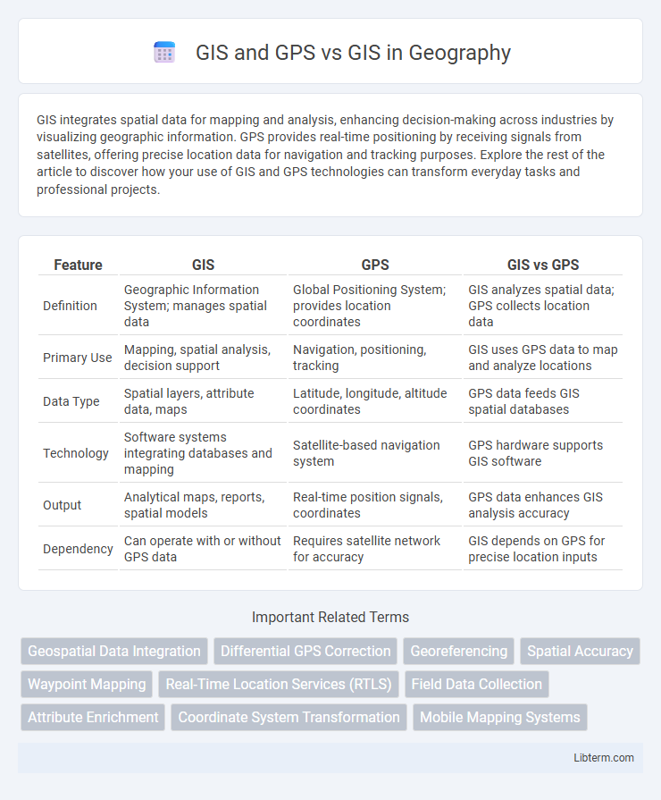
Table of Comparison
| Feature | GIS | GPS | GIS vs GPS |
|---|---|---|---|
| Definition | Geographic Information System; manages spatial data | Global Positioning System; provides location coordinates | GIS analyzes spatial data; GPS collects location data |
| Primary Use | Mapping, spatial analysis, decision support | Navigation, positioning, tracking | GIS uses GPS data to map and analyze locations |
| Data Type | Spatial layers, attribute data, maps | Latitude, longitude, altitude coordinates | GPS data feeds GIS spatial databases |
| Technology | Software systems integrating databases and mapping | Satellite-based navigation system | GPS hardware supports GIS software |
| Output | Analytical maps, reports, spatial models | Real-time position signals, coordinates | GPS data enhances GIS analysis accuracy |
| Dependency | Can operate with or without GPS data | Requires satellite network for accuracy | GIS depends on GPS for precise location inputs |
Introduction to GIS and GPS Technologies
Geographic Information Systems (GIS) integrate hardware, software, and data to capture, analyze, and visualize spatial information, enabling detailed mapping and decision-making for urban planning, environmental management, and resource allocation. Global Positioning System (GPS) technology provides precise location data through satellite signals, facilitating real-time tracking and navigation with applications in transportation, surveying, and geolocation services. While GIS focuses on spatial data manipulation and analysis, GPS primarily serves as a data source that feeds accurate positional information into GIS databases for enhanced spatial awareness.
Fundamental Differences Between GIS and GPS
Geographic Information Systems (GIS) primarily manage, analyze, and visualize spatial data through layered information tied to geographic locations, enabling complex decision-making and mapping. Global Positioning System (GPS) is a satellite-based navigation system providing real-time location coordinates and tracking for objects or individuals on the earth's surface. The fundamental difference lies in GIS being a data analysis and mapping tool, while GPS functions as a positioning and navigation technology used to collect spatial data.
Core Functions of GIS: Data Analysis and Mapping
GIS excels in data analysis and mapping by integrating spatial and attribute data to visualize patterns, relationships, and trends across geographic areas. Unlike GPS, which primarily provides precise location coordinates, GIS processes and analyzes diverse datasets to support decision-making in urban planning, environmental monitoring, and resource management. Core GIS functions include layering multiple data sources, performing spatial queries, and generating thematic maps that offer deeper insights beyond mere location tracking.
GPS: Precision Positioning and Navigation
GPS offers unparalleled precision positioning by utilizing a network of at least 24 satellites to provide accurate location data globally, with typical accuracy levels within 5 meters for civilian use. Unlike traditional GIS, which relies on mapping and spatial analysis from static data sets, GPS delivers real-time navigation and dynamic positioning critical for applications in transportation, surveying, and emergency response. Integrating GPS with GIS enhances spatial analysis by combining real-time location tracking with comprehensive geographic data, improving decision-making and operational efficiency.
Integration of GIS and GPS: Enhanced Spatial Solutions
Integration of GIS and GPS creates powerful spatial solutions by combining real-time location data with detailed geographic information. This synergy enhances accuracy in mapping, navigation, and spatial analysis, benefiting applications like urban planning, disaster management, and environmental monitoring. Leveraging GPS data within GIS platforms enables dynamic updates and improved decision-making through precise geospatial context.
Use Cases: GIS Alone vs. GIS Integrated with GPS
GIS alone excels in spatial data analysis, mapping, and resource management within fields like urban planning, environmental monitoring, and disaster management. Integrating GPS with GIS enhances real-time location tracking, navigation, and asset management, enabling precise field data collection and dynamic route optimization in logistics, agriculture, and emergency response operations. This synergy improves decision-making accuracy by combining geographic context with exact positioning coordinates.
Data Collection: Fieldwork Efficiency with GPS-Enriched GIS
GIS enhances spatial data analysis by integrating diverse datasets, while GPS significantly improves data collection accuracy during fieldwork. Using GPS-enriched GIS allows real-time location tracking, reducing errors and time spent on manual data entry. This combination boosts fieldwork efficiency, enabling precise geospatial mapping and faster decision-making processes.
Accuracy and Reliability: Comparing GIS, GPS, and Their Combination
GIS offers robust spatial data analysis but relies on data quality, while GPS provides real-time geographic positioning with high accuracy but can be affected by signal obstructions. Combining GIS and GPS enhances accuracy and reliability by integrating precise location data with comprehensive spatial analysis, enabling more informed decision-making. This synergy proves essential in applications like urban planning, navigation, and environmental monitoring, where precision and dependable data are critical.
Limitations and Challenges: GIS Standalone vs. GIS with GPS
GIS standalone systems often face challenges related to data accuracy, timeliness, and spatial resolution due to reliance on static or manually collected datasets. Integrating GPS enhances GIS by providing real-time, precise location data, but it introduces limitations such as signal loss in dense urban or heavily forested areas and increased complexity in data synchronization. Both configurations demand robust data management strategies to address issues of data consistency, hardware maintenance, and user training for optimal spatial analysis outcomes.
Future Trends in Geospatial Technologies: Merging GIS and GPS
Future trends in geospatial technologies emphasize the integration of GIS (Geographic Information Systems) and GPS (Global Positioning System) to enhance spatial data accuracy and real-time location tracking. Advances in AI and machine learning are enabling predictive analytics within GIS platforms, leveraging high-precision GPS data for dynamic mapping and autonomous navigation applications. The convergence of GIS and GPS facilitates augmented reality, smart city infrastructure, and improved disaster response through seamless spatial data interoperability and enhanced geospatial intelligence.
GIS and GPS Infographic