A ravine is a deep, narrow valley with steep sides, often formed by river erosion over time, creating a striking natural landscape. These landforms are significant in shaping ecosystems and influencing local biodiversity due to their unique microclimates and water flow patterns. Explore the rest of the article to understand how ravines impact the environment and their role in geography.
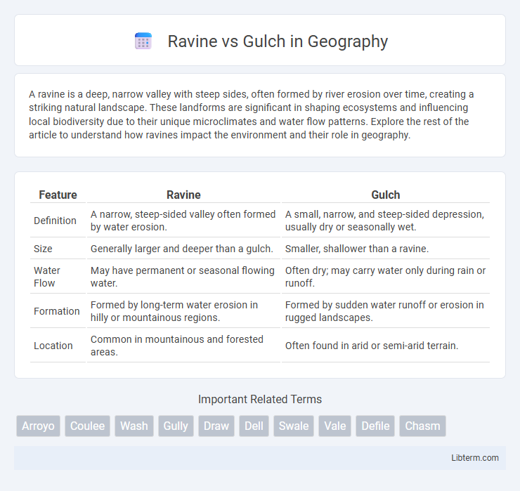
Table of Comparison
| Feature | Ravine | Gulch |
|---|---|---|
| Definition | A narrow, steep-sided valley often formed by water erosion. | A small, narrow, and steep-sided depression, usually dry or seasonally wet. |
| Size | Generally larger and deeper than a gulch. | Smaller, shallower than a ravine. |
| Water Flow | May have permanent or seasonal flowing water. | Often dry; may carry water only during rain or runoff. |
| Formation | Formed by long-term water erosion in hilly or mountainous regions. | Formed by sudden water runoff or erosion in rugged landscapes. |
| Location | Common in mountainous and forested areas. | Often found in arid or semi-arid terrain. |
Understanding Ravines and Gulches: Key Differences
Ravines and gulches both refer to narrow, steep-sided landforms but differ in scale and formation processes. A ravine is typically wider and formed by prolonged water erosion, featuring moderate slopes and often vegetated. In contrast, a gulch is usually narrower, steeper, and results from more abrupt water flow or flash flooding, creating distinct, sharp terrain features.
Geological Formation: How Ravines and Gulches Develop
Ravines form through the gradual erosion of soil and rock by flowing water, often originating from rainfall runoff or melting snow that carves narrow, steep-sided valleys. Gulches develop similarly but typically result from more intense, rapid erosion processes in arid or semi-arid regions, often influenced by sporadic heavy rains that create deeper channels. Both features illustrate erosional landforms shaped by water movement, but ravines usually represent longer-term, consistent water flow, while gulches are more associated with episodic, high-energy erosion events.
Physical Characteristics of Ravines
Ravines are narrow, steep-sided valleys often formed by water erosion, characterized by sharply defined slopes and varying depths that typically range from a few meters to several tens of meters. They commonly contain a stream or river at their base, which actively shapes the terrain through sediment transport and drainage patterns. The physical structure of ravines distinguishes them from gulches by their more pronounced vertical walls and less extensive floor area.
Distinctive Features of Gulches
Gulches are characterized by steep, narrow V-shaped valleys often formed by the rapid erosion of water, typically smaller and more confined than ravines. Their distinctive features include sharply incised channels, steep walls, and a tendency to carry seasonal or intermittent streams, distinguishing them from broader and more gently sloping ravines. These geological formations often serve as crucial drainage pathways in mountainous or hilly terrain, emphasizing their role in landscape erosion and hydrology.
Size and Scale: Comparing Ravines and Gulches
Ravines typically span larger areas with steep sides and a depth that often exceeds 10 meters, making them more prominent landforms compared to gulches, which are narrower and shallower depressions usually less than 10 meters deep. The size of a ravine can extend several kilometers in length, while gulches are often confined to shorter distances and smaller watershed areas. Both landforms result from erosion, but the scale of ravines generally indicates more significant water flow and geological activity.
Hydrology: Water Flow Patterns in Ravines vs Gulches
Ravines typically exhibit more continuous water flow due to their steeper gradients and deeper channels, allowing for efficient drainage of runoff and groundwater. Gulches often experience intermittent flow, with water movement primarily occurring during heavy precipitation events, leading to more sporadic discharge patterns. Both landforms influence local hydrology by directing surface water, but ravines generally support a more stable and persistent hydrological system compared to the ephemeral channels in gulches.
Common Locations and Global Distribution
Ravines and gulches commonly occur in mountainous and hilly regions where water erosion shapes the landscape, such as the Appalachian Mountains in the United States and the Scottish Highlands. Ravines are frequently found in temperate climates with moderate to heavy rainfall, supporting dense vegetation along their steep sides. Gulches often appear in arid to semi-arid environments like the Western United States and Central Asia, characterized by narrow, rugged channels formed by intermittent streams.
Ecological Significance of Ravines and Gulches
Ravines and gulches serve as critical ecological zones that support diverse plant and animal species by providing unique microhabitats and moisture retention. Ravines typically have steeper slopes and more stable soils, promoting the growth of dense vegetation and serving as natural corridors for wildlife movement. Gulches, often formed by intermittent streams, contribute to sediment transport and nutrient cycling, enhancing soil fertility and supporting riparian ecosystems.
Human Interaction and Land Use
Ravines and gulches both influence human land use through their distinct topographies and water flow characteristics, impacting settlement patterns and agricultural practices. Ravines, often deeper and more stable, are frequently utilized for controlled drainage, hiking trails, and conservation areas, minimizing soil erosion and supporting biodiversity. In contrast, gulches, with steeper slopes and intermittent streams, pose challenges for construction and farming but can serve as natural channels for stormwater management and habitat corridors.
Choosing the Right Terminology: Ravine vs Gulch
Choosing the right terminology between ravine and gulch depends on geographic and geological context, where a ravine is typically a narrow, steep-sided valley often formed by water erosion, while a gulch refers to a deep, narrow ravine with a fast-flowing stream or dry channel. In regions with arid climates, gulch is more commonly used to describe ephemeral watercourses, whereas ravine is prevalent in areas with consistent rainfall and vegetation. Accurate usage enhances clarity in environmental studies, mapping, and landform description, aligning with local and scientific conventions.
Ravine Infographic