Isohyets represent lines on a map that connect points of equal rainfall, providing critical insights into precipitation distribution across different regions. These contours help meteorologists, farmers, and planners understand rainfall patterns, which is essential for agriculture, water resource management, and climate studies. Explore the rest of the article to learn how isohyets influence environmental planning and decision-making for your area.
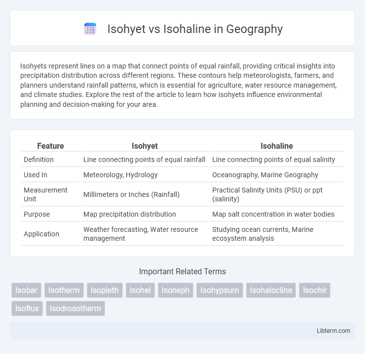
Table of Comparison
| Feature | Isohyet | Isohaline |
|---|---|---|
| Definition | Line connecting points of equal rainfall | Line connecting points of equal salinity |
| Used In | Meteorology, Hydrology | Oceanography, Marine Geography |
| Measurement Unit | Millimeters or Inches (Rainfall) | Practical Salinity Units (PSU) or ppt (salinity) |
| Purpose | Map precipitation distribution | Map salt concentration in water bodies |
| Application | Weather forecasting, Water resource management | Studying ocean currents, Marine ecosystem analysis |
Introduction to Isohyet and Isohaline
Isohyets are contour lines on a map connecting points of equal precipitation, crucial for analyzing rainfall distribution and hydrological studies. Isohalines represent lines linking locations with the same salinity level, primarily used in oceanography and environmental science to study salinity variations in water bodies. Both concepts aid in interpreting climatic and marine patterns by depicting spatial variations in essential environmental parameters.
Definition of Isohyet
An Isohyet is a contour line on a map that connects points of equal precipitation, offering critical insights for meteorologists and hydrologists in understanding rainfall distribution. In contrast, an Isohaline represents lines of equal salinity in bodies of water, serving marine scientists and oceanographers in salinity pattern analysis. Isohyets are essential for water resource management, flood prediction, and agricultural planning due to their precise depiction of rainfall gradients.
Definition of Isohaline
Isohaline refers to a line on a map connecting points of equal salinity in bodies of water, crucial for studying marine environments and coastal ecosystems. Unlike isohyets, which denote areas of equal precipitation, isohaline maps help scientists monitor saltwater intrusion, marine species distribution, and water quality changes. Understanding isohaline patterns supports environmental management and pollution control in estuaries and oceanographic research.
Key Differences Between Isohyet and Isohaline
Isohyets represent lines on a map connecting points of equal precipitation, crucial for analyzing rainfall distribution, while Isohalines depict lines of equal salinity, essential for studying coastal and oceanic water characteristics. Isohyets help in hydrological studies and water resource management by mapping rainfall patterns, whereas Isohalines are key for marine ecology and understanding saltwater intrusion in estuaries. Distinguishing between these helps in applying the correct data for environmental assessments and climate research.
Importance in Meteorology and Oceanography
Isohyets represent lines of equal rainfall intensity on meteorological maps, essential for analyzing precipitation distribution and forecasting weather patterns. Isohalines depict lines of equal salinity in oceanography, crucial for understanding saltwater intrusion, marine ecosystems, and ocean circulation. Both isohyet and isohaline contours provide critical spatial data for climate studies, water resource management, and environmental monitoring.
Methods of Mapping Isohyets
Mapping isohyets involves collecting precise rainfall data from weather stations and interpolating values between points using methods such as Thiessen polygons, inverse distance weighting (IDW), and kriging to generate continuous lines representing equal precipitation levels. These spatial analysis techniques account for the variability and distribution of rainfall across a geographic area, enhancing accuracy in precipitation mapping. Unlike isohalines that map salinity by measuring salt concentration gradients, isohyet mapping requires temporal aggregation of precipitation data to reflect rainfall patterns over specific periods.
Techniques for Creating Isohalines
Isohalines are lines on a map connecting points of equal salinity in bodies of water, created using techniques such as remote sensing, in-situ water sampling, and geostatistical interpolation methods like kriging. These methods involve collecting salinity data at multiple locations and depths, then using spatial analysis to generate continuous salinity contours. In contrast to isohyet lines, which represent precipitation totals, isohaline mapping focuses on salinity gradients critical for marine and estuarine studies.
Applications in Environmental Science
Isohyets and isohalines play crucial roles in environmental science by aiding in the analysis of spatial variations in precipitation and salinity, respectively. Isohyets facilitate water resource management, flood prediction, and agricultural planning by mapping rainfall distribution over a geographic area. Isohalines are essential for studying estuarine and coastal ecosystems, tracking seawater intrusion, and monitoring changes in water quality due to salinity fluctuations.
Challenges in Data Collection and Interpretation
Differentiating isohyets, which represent lines of equal precipitation, from isohalines, which depict lines of equal salinity, presents challenges due to varying spatial and temporal data scales. Accurate data collection for isohyets depends on dense rain gauge networks that may be limited by geographic accessibility, while isohaline measurements require precise salinity sampling often influenced by fluctuating tidal and oceanic conditions. Interpreting these datasets demands sophisticated geospatial analysis to account for environmental variability and measurement inconsistencies, complicating comparative studies and hydrological modeling.
Conclusion: Comparing Isohyet and Isohaline
Isohyet maps represent lines of equal rainfall, providing crucial data for hydrology and agricultural planning, while Isohaline maps connect points of equal salinity, essential for marine science and estuarine ecosystem management. Understanding the distinction between these isolines enables better interpretation of climatic and aquatic environmental patterns, aiding in resource management and environmental conservation. In conclusion, Isohyet and Isohaline serve distinct scientific purposes, with each playing a vital role in analyzing precipitation and salinity distribution, respectively.
Isohyet Infographic