Georeferencing accurately aligns spatial data with real-world geographic coordinates, enabling seamless integration of maps and satellite images for analysis and visualization. This process enhances the precision of GIS projects by ensuring that different datasets correspond correctly to actual locations on the Earth's surface. Discover how mastering georeferencing can elevate your mapping capabilities in the rest of this article.
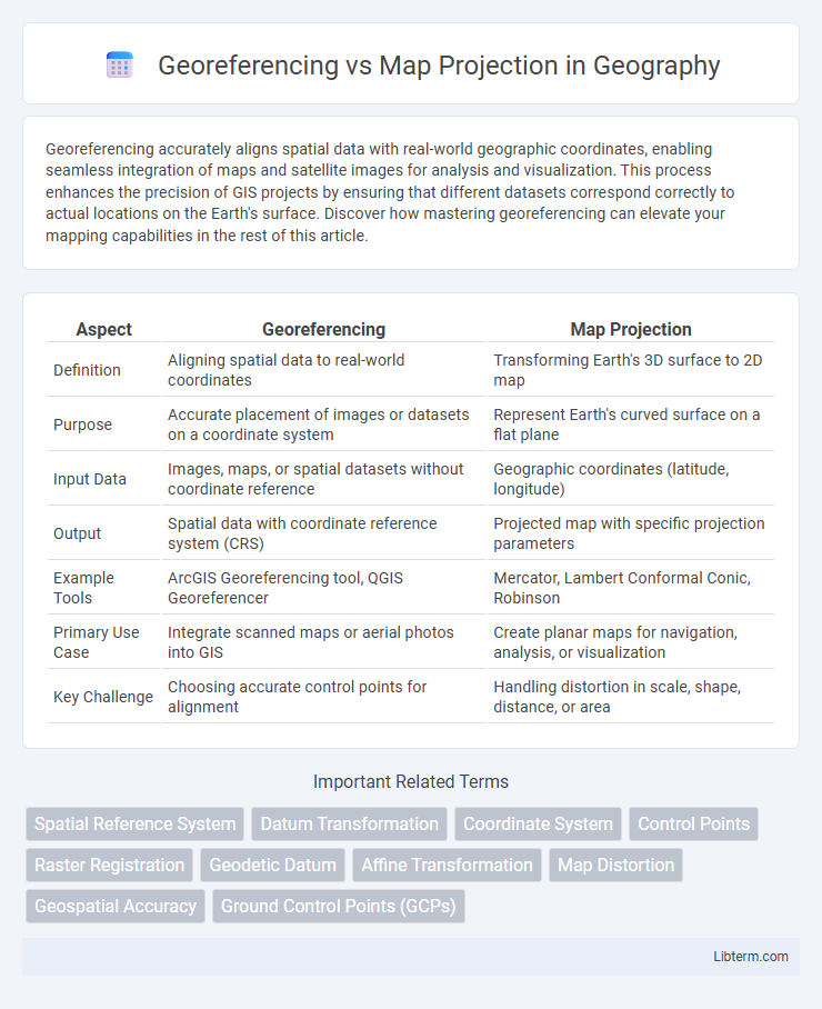
Table of Comparison
| Aspect | Georeferencing | Map Projection |
|---|---|---|
| Definition | Aligning spatial data to real-world coordinates | Transforming Earth's 3D surface to 2D map |
| Purpose | Accurate placement of images or datasets on a coordinate system | Represent Earth's curved surface on a flat plane |
| Input Data | Images, maps, or spatial datasets without coordinate reference | Geographic coordinates (latitude, longitude) |
| Output | Spatial data with coordinate reference system (CRS) | Projected map with specific projection parameters |
| Example Tools | ArcGIS Georeferencing tool, QGIS Georeferencer | Mercator, Lambert Conformal Conic, Robinson |
| Primary Use Case | Integrate scanned maps or aerial photos into GIS | Create planar maps for navigation, analysis, or visualization |
| Key Challenge | Choosing accurate control points for alignment | Handling distortion in scale, shape, distance, or area |
Introduction to Georeferencing and Map Projection
Georeferencing assigns real-world coordinates to spatial data, enabling accurate overlay on global coordinate systems essential for Geographic Information Systems (GIS). Map projection transforms the curved surface of the Earth onto a flat plane, using mathematical formulas to preserve properties like area, shape, distance, or direction depending on the projection type. Understanding georeferencing and map projection is crucial for integrating diverse spatial datasets accurately while minimizing distortions inherent in flattening the globe.
Defining Georeferencing: Purpose and Process
Georeferencing involves aligning geographic data to a known coordinate system, enabling accurate location identification on Earth's surface. This process assigns real-world coordinates to spatial data points, ensuring that maps and satellite images correspond precisely to physical locations. Unlike map projection, which transforms the Earth's curved surface into a flat map, georeferencing focuses on anchoring data within a specific spatial reference framework for accurate analysis and mapping.
Understanding Map Projections: Types and Uses
Map projections transform the three-dimensional Earth surface onto a two-dimensional plane, with common types including cylindrical, conic, and azimuthal projections, each designed for specific regional or thematic uses. Cylindrical projections, such as Mercator, preserve angles and shapes, making them ideal for navigation, while conic projections excel in accurately representing mid-latitude areas with minimal distortion. Azimuthal projections focus on preserving directions from a central point, often used in polar mapping or radio signal analysis, emphasizing the importance of choosing a projection based on spatial accuracy needs and purpose.
Key Differences Between Georeferencing and Map Projection
Georeferencing aligns spatial data to a known coordinate system, enabling integration with other geographic datasets, while map projection transforms the Earth's curved surface onto a flat plane, altering spatial relationships to minimize distortion. Georeferencing deals with positioning and referencing existing data points, whereas map projection involves mathematical formulas to convert three-dimensional coordinates into two-dimensional maps. Understanding these key differences is essential for accurate spatial analysis and cartographic representation.
The Importance of Accurate Georeferencing in GIS
Accurate georeferencing is crucial in GIS because it ensures that spatial data aligns correctly with real-world locations, enabling precise analysis and decision-making. Unlike map projection, which transforms the earth's curved surface to a flat map, georeferencing involves assigning real-world coordinates to raster or vector data, facilitating integration of diverse datasets. Errors in georeferencing can result in misinterpretation of spatial relationships, affecting Urban Planning, Environmental Monitoring, and Disaster Management outcomes.
Common Map Projection Methods Explained
Common map projection methods such as Mercator, Lambert Conformal Conic, and Albers Equal-Area are essential for transforming the 3D surface of the Earth onto 2D maps while preserving specific spatial properties like angles, area, or distance. Georeferencing aligns spatial data to real-world coordinates, enabling accurate mapping and analysis, but differs from map projection, which mathematically converts geographic coordinates to planar coordinates. Understanding these projection methods is crucial for applications in GIS, cartography, and spatial analysis to ensure spatial data accuracy and integrity.
How Map Projections Affect Spatial Data Accuracy
Map projections transform the curved surface of the Earth onto a flat plane, inherently causing distortions in distance, area, shape, or direction. Different projection types, such as Mercator or Albers Equal Area, prioritize preserving certain spatial properties at the expense of others, directly affecting the accuracy of spatial data representations. Understanding the specific distortions introduced by a chosen map projection is critical for spatial analysis, ensuring data interpretation aligns with the purpose of mapping and minimizes errors in geographical measurements.
Practical Applications: Georeferencing vs. Map Projection
Georeferencing involves aligning spatial data to real-world coordinates, enabling accurate overlay and integration of diverse geographic datasets in practical applications like urban planning and environmental monitoring. Map projection transforms the curved surface of the Earth onto a flat map, essential for creating navigational charts and spatial analysis with minimized distortions. Together, georeferencing and map projections enhance the precision and usability of geographic information systems (GIS) in fields such as surveying, land management, and disaster response.
Challenges and Limitations of Each Technique
Georeferencing faces challenges such as positional inaccuracies caused by imprecise control points and distortions from varying source map scales or outdated data. Map projection limitations include inherent distortions of area, shape, distance, or direction due to the transformation of the earth's three-dimensional surface onto a two-dimensional plane, making certain projections unsuitable for specific spatial analyses. Both techniques require careful selection and correction methods to minimize errors, yet cannot entirely eliminate spatial distortions or mismatches.
Choosing the Right Approach for Your Mapping Project
Georeferencing aligns spatial data to real-world coordinates by linking imagery or maps to geographic locations, ideal for integrating diverse datasets without altering their original format. Map projection transforms the Earth's curved surface into a flat map, essential for accurate distance, area, or direction measurements within specific regions. Selecting the right approach depends on the project's purpose: georeferencing suits data integration and overlay, while map projection is crucial for spatial analysis and creating standardized maps.
Georeferencing Infographic