Geochronology is the science of determining the age of rocks, fossils, and sediments using signatures inherent in their composition. Techniques such as radiometric dating allow scientists to establish a timeline of Earth's history and the evolution of life. Explore the article to uncover how geochronology provides crucial insights into our planet's past and your understanding of geological time.
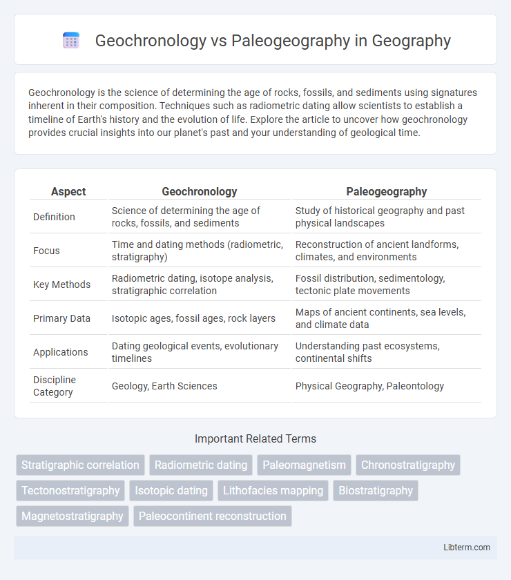
Table of Comparison
| Aspect | Geochronology | Paleogeography |
|---|---|---|
| Definition | Science of determining the age of rocks, fossils, and sediments | Study of historical geography and past physical landscapes |
| Focus | Time and dating methods (radiometric, stratigraphy) | Reconstruction of ancient landforms, climates, and environments |
| Key Methods | Radiometric dating, isotope analysis, stratigraphic correlation | Fossil distribution, sedimentology, tectonic plate movements |
| Primary Data | Isotopic ages, fossil ages, rock layers | Maps of ancient continents, sea levels, and climate data |
| Applications | Dating geological events, evolutionary timelines | Understanding past ecosystems, continental shifts |
| Discipline Category | Geology, Earth Sciences | Physical Geography, Paleontology |
Introduction to Geochronology and Paleogeography
Geochronology is the science of determining the age of rocks, fossils, and sediments using methods such as radiometric dating and stratigraphy to establish a chronological framework for Earth's history. Paleogeography reconstructs past geographic landscapes and environments by analyzing sedimentary records, fossil distribution, and tectonic shifts to understand ancient earth configurations. Together, geochronology provides the temporal context essential for accurate paleogeographic reconstructions of historical landmasses and ecosystems.
Defining Geochronology: Concepts and Methods
Geochronology is the scientific discipline that determines the age and timing of geological events by measuring the decay of radioactive isotopes and analyzing stratigraphic layers. Techniques such as radiometric dating, including uranium-lead, potassium-argon, and carbon-14 methods, are fundamental for establishing absolute geological timelines. This contrasts with paleogeography, which reconstructs past geographic configurations and environmental conditions based on sedimentological and fossil evidence.
Understanding Paleogeography: Key Principles
Understanding paleogeography involves reconstructing Earth's past landscapes and environmental conditions based on geological, fossil, and sedimentary evidence. Geochronology provides precise dating techniques, such as radiometric methods, to establish the temporal framework crucial for accurate paleogeographic maps. Integrating stratigraphic data with geochronological timelines enables scientists to track continental drift, sea-level changes, and climate evolution throughout geologic history.
Historical Development of Geochronology and Paleogeography
Geochronology developed through advancements in radiometric dating techniques during the early 20th century, allowing precise age determination of rocks and fossils, which significantly refined the geologic time scale. Paleogeography evolved alongside geochronology, with early cartographic reconstructions of ancient landmasses based on sedimentology, fossil distribution, and plate tectonics concepts emerging prominently in the mid-1900s. Both sciences progressively integrated multidisciplinary data, enhancing understanding of Earth's dynamic history and paleoenvironments.
Techniques Used in Geochronology
Geochronology employs advanced techniques such as radiometric dating, including uranium-lead, potassium-argon, and carbon-14 methods, to determine the absolute ages of rocks and fossils. Isotopic analysis and magnetostratigraphy also play crucial roles in providing precise time scales, enabling accurate reconstruction of Earth's history. These techniques offer a temporal framework that complements paleogeographic studies by anchoring spatial distributions of ancient environments to specific geological periods.
Tools and Data Sources in Paleogeography
Paleogeography relies heavily on tools like geographic information systems (GIS), sedimentological analysis, and paleomagnetic data to reconstruct ancient land and sea distributions. Key data sources include fossil assemblages, stratigraphic records, and isotope geochemistry, which provide insights into past climates, tectonic plate movements, and biogeographic patterns. Integrating these datasets enables accurate mapping of historical environments and continental configurations over geological time.
Comparing Objectives: Time vs. Place
Geochronology focuses on determining the age and timing of geological events through methods like radiometric dating and stratigraphy, aiming to establish a precise temporal framework for Earth's history. Paleogeography, on the other hand, reconstructs ancient landscapes, climates, and spatial distributions of land and sea by analyzing sedimentary records, fossils, and tectonic movements to understand past geographic configurations. Both disciplines complement each other by linking the temporal context provided by geochronology with the spatial reconstructions of paleogeography to interpret Earth's evolutionary and environmental changes comprehensively.
Interrelationship Between Geochronology and Paleogeography
Geochronology provides precise dating techniques such as radiometric dating, which establishes the temporal framework essential for reconstructing paleogeographic maps of past Earth landscapes and tectonic shifts. Paleogeography utilizes geochronological data to correlate sedimentary layers and fossil distributions, enabling accurate interpretations of ancient environments and climatic conditions. Their interrelationship is crucial for understanding Earth's historical geology, as geochronological timelines enhance the spatial reconstructions offered by paleogeographic studies.
Applications in Earth Sciences and Industry
Geochronology provides precise dating of rocks and fossils, essential for reconstructing Earth's temporal history and calibrating geological events, thereby guiding mineral exploration and hydrocarbon reservoir assessment. Paleogeography maps ancient landforms and environmental conditions, aiding in the interpretation of sedimentary basins and climate evolution critical for oil and gas exploration and environmental geology. Both disciplines complement each other to enhance resource exploration, natural hazard prediction, and understanding of Earth's dynamic systems.
Future Directions and Emerging Technologies
Emerging technologies such as high-resolution isotope geochemistry and machine learning are revolutionizing geochronology by enabling more precise dating of geological events and enhancing temporal resolution. Advances in paleogeography leverage satellite remote sensing and 3D modeling to reconstruct ancient landscapes with unprecedented accuracy, aiding in understanding Earth's dynamic history. Integrating these innovations promises to refine temporal-spatial correlations, facilitating more robust climate and tectonic reconstructions for future Earth system science research.
Geochronology Infographic