Remote sensing involves acquiring information about the Earth's surface without direct contact, using satellite or aerial sensor technologies. It plays a crucial role in environmental monitoring, urban planning, and disaster management by providing accurate, real-time data. Discover how remote sensing can enhance Your understanding and decision-making in the following article.
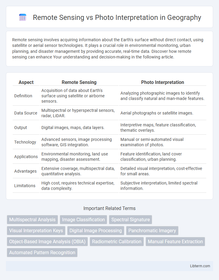
Table of Comparison
| Aspect | Remote Sensing | Photo Interpretation |
|---|---|---|
| Definition | Acquisition of data about Earth's surface using satellite or airborne sensors. | Analyzing photographic images to identify and classify natural and man-made features. |
| Data Source | Multispectral or hyperspectral sensors, radar, LiDAR. | Aerial photographs or satellite images. |
| Output | Digital images, maps, data layers. | Interpretive maps, feature classification, thematic overlays. |
| Technology | Advanced sensors, image processing software, GIS integration. | Manual or semi-automated visual examination of photos. |
| Applications | Environmental monitoring, land use mapping, disaster assessment. | Feature identification, land cover classification, urban planning. |
| Advantages | Extensive coverage, multispectral data, quantitative analysis. | Detailed visual interpretation, cost-effective for small areas. |
| Limitations | High cost, requires technical expertise, data complexity. | Subjective interpretation, limited spectral information. |
Introduction to Remote Sensing and Photo Interpretation
Remote sensing involves acquiring information about Earth's surface without direct contact, using sensors on satellites or aircraft to collect data across various electromagnetic spectrum bands. Photo interpretation focuses on analyzing and extracting meaningful information from aerial or satellite images by examining features such as texture, tone, shape, and pattern. Both techniques are essential in geographic information systems (GIS), environmental monitoring, and land-use planning for accurate spatial data analysis.
Core Concepts: Definitions and Differences
Remote sensing involves acquiring data about objects or areas from a distance, typically using satellite or aerial sensors to capture electromagnetic radiation reflected or emitted by the Earth's surface. Photo interpretation is the analytical process of examining aerial photographs or remotely sensed images to identify and classify features based on shape, tone, texture, and context. While remote sensing provides raw multispectral or hyperspectral data, photo interpretation focuses on extracting meaningful information through visual analysis and pattern recognition, making it integral for applications in geography, environmental monitoring, and land-use planning.
History and Evolution of Remote Sensing
Remote sensing originated in the early 20th century with aerial photography, evolving significantly during World War II when reconnaissance aircraft captured extensive terrain images. The launch of Earth-observing satellites, such as Landsat in 1972, marked a pivotal advancement, expanding data acquisition capabilities beyond the visible spectrum. Modern remote sensing integrates multispectral and hyperspectral imaging technologies, enabling detailed environmental monitoring and resource management far beyond the traditional photo interpretation methods.
Photo Interpretation: Origins and Methodologies
Photo interpretation originated during World War I when aerial reconnaissance images were first analyzed for military intelligence. The methodology involves analyzing photographic images by identifying patterns, textures, shapes, and shadows to extract meaningful information about the terrain or objects. Techniques include visual analysis and manual annotation, emphasizing human expertise to interpret spatial relationships and temporal changes, distinguishing it from automated remote sensing processes.
Data Acquisition: Satellites vs. Aerial Photography
Remote sensing primarily relies on satellite data acquisition, offering extensive, repetitive coverage with consistent spectral and spatial resolution across large geographic areas. In contrast, photo interpretation depends on aerial photography, which provides high-resolution, detailed images ideal for localized analysis but with limited spatial coverage and less frequent updates. Satellite sensors capture multispectral and hyperspectral data, enabling advanced analysis beyond visual wavelengths, whereas aerial photography mainly captures visible light, constraining the depth of data interpretation.
Tools and Technologies in Remote Sensing
Remote sensing utilizes advanced tools such as satellites, drones, multispectral and hyperspectral sensors, LiDAR, and radar systems to capture data across various electromagnetic spectrum bands, enabling detailed environmental analysis. These technologies provide precise, large-scale, and real-time data collection, improving accuracy over traditional photo interpretation methods that rely on aerial photographs and manual analysis. Integration of Geographic Information Systems (GIS) and artificial intelligence (AI) further enhances data processing, classification, and interpretation in remote sensing applications.
Visual Analysis Techniques in Photo Interpretation
Visual analysis techniques in photo interpretation involve systematically examining aerial and satellite images to identify and classify land features and objects based on shape, size, pattern, tone, texture, and shadow. This process relies heavily on human expertise for detecting subtle details and contextual clues that automated remote sensing algorithms might overlook. Accurate visual interpretation enhances thematic mapping, environmental monitoring, and resource management by providing detailed qualitative insights complementing quantitative remote sensing data.
Applications Across Various Industries
Remote sensing provides real-time, multispectral data crucial for precision agriculture, environmental monitoring, and disaster management, enabling accurate crop health analysis, deforestation tracking, and flood assessment. Photo interpretation, relying on manual analysis of aerial or satellite images, is widely used in urban planning, archaeology, and military reconnaissance for detailed feature identification and mapping. Combining both techniques enhances geospatial analysis, supporting industries like mining, forestry, and insurance with improved decision-making and risk management.
Advantages and Limitations Compared
Remote sensing offers advantages like large-area coverage, real-time data acquisition, and multispectral capabilities, enabling analysis beyond visible light. Photo interpretation provides detailed visual context and ease of use with aerial photographs, facilitating intuitive identification of features. Limitations include remote sensing's dependency on sensor resolution and atmospheric conditions, while photo interpretation is constrained by scale, subjective analysis, and lack of spectral information.
Future Trends in Geospatial Analysis
Future trends in geospatial analysis emphasize the integration of remote sensing and photo interpretation through advanced AI and machine learning algorithms, enhancing accuracy and automation in data extraction. Enhanced satellite sensor technologies and real-time data processing capabilities are driving more precise environmental monitoring and disaster management. The convergence of 3D imaging, hyperspectral data, and big data analytics is revolutionizing spatial understanding and decision-making processes in urban planning and resource management.
Remote Sensing Infographic