A pediplain is an extensive, nearly level land surface formed by the coalescence of pediments in arid or semi-arid regions, representing the final stage of long-term erosion. These broad plains often reveal the landscape's geological history and the processes of weathering and erosion that shaped it. Discover how understanding pediplains can enhance your knowledge of geomorphology by reading the rest of this article.
Table of Comparison
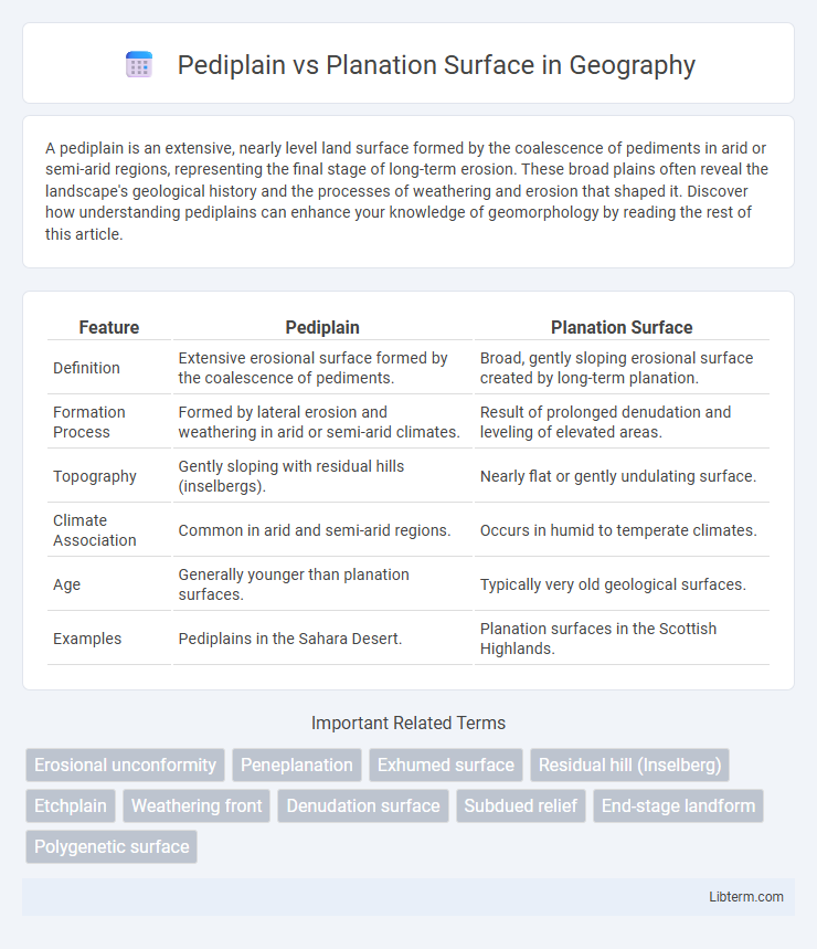
| Feature | Pediplain | Planation Surface |
|---|---|---|
| Definition | Extensive erosional surface formed by the coalescence of pediments. | Broad, gently sloping erosional surface created by long-term planation. |
| Formation Process | Formed by lateral erosion and weathering in arid or semi-arid climates. | Result of prolonged denudation and leveling of elevated areas. |
| Topography | Gently sloping with residual hills (inselbergs). | Nearly flat or gently undulating surface. |
| Climate Association | Common in arid and semi-arid regions. | Occurs in humid to temperate climates. |
| Age | Generally younger than planation surfaces. | Typically very old geological surfaces. |
| Examples | Pediplains in the Sahara Desert. | Planation surfaces in the Scottish Highlands. |
Introduction to Pediplain and Planation Surface
Pediplains are extensive, gently undulating landscapes formed primarily through the coalescence of pediments in arid and semi-arid regions, characterized by gradual erosion and sediment deposition. Planation surfaces represent large, relatively flat landforms created by prolonged erosion processes that reduce the landscape to near base level, often found in various climatic zones. Both pediplains and planation surfaces serve as key indicators of long-term geomorphological evolution and landscape denudation.
Definition of Pediplain
A pediplain is a broad, nearly flat erosional surface formed by the coalescence of pediments, created primarily in arid or semi-arid regions through the retreat of slopes by weathering and erosion. Unlike a planation surface, which is a more generalized, extensive flat area often formed under humid conditions through uniform erosion, a pediplain results from the merging of smaller erosion surfaces at the base of receding hills. Pediplains represent a distinct geomorphic feature characterized by their origin linked to slope retreat and the accumulation of fine sediment over time.
Definition of Planation Surface
A planation surface is a broad, nearly level landform created by long-term erosion processes that reduce landscapes to low-relief surfaces. Unlike a pediplain, which forms through the coalescence of pediments primarily in arid regions, a planation surface represents extensive planation marked by surface lowering and widespread removal of topographic irregularities. This geological feature illustrates a mature stage of landscape evolution shaped by agents such as water, wind, and chemical weathering.
Formation Processes of Pediplains
Pediplains form through the coalescence of pediments created by extensive lateral erosion in arid and semi-arid climates, where weathering and sediment removal gradually expose a broad, gently sloping surface. This process involves the retreat of steep slopes and the accumulation of debris at the base of escarpments, resulting in a landscape dominated by residually weathered rock and thin soil cover. Planation surfaces differ by typically forming via widespread planation and leveling, often involving fluvial or glacial erosion, rather than the specific pediment development characteristic of pediplains.
Formation Processes of Planation Surfaces
Planation surfaces form primarily through long-term denudation processes such as weathering, erosion, and mass wasting, resulting in extensive, nearly level landscapes. Unlike pediplains, which develop through the lateral coalescence of pediments under arid climates, planation surfaces emerge through uniform lowering and leveling of land by agents like water, wind, and glacial activity. These surfaces reflect prolonged tectonic stability, allowing for deep weathering and sediment removal that create broad, gently undulating terraces or peneplains.
Key Differences Between Pediplain and Planation Surface
Pediplains form through extensive lateral erosion and the coalescence of pediments in arid climates, resulting in a gently undulating surface with scattered inselbergs, whereas planation surfaces develop mainly via prolonged planation processes like pedimentation and sheetwash, producing broad, flat, or gently undulating terrains often associated with humid environments. Pediplains typically exhibit polycyclic features reflecting multiple cycles of erosion and weathering, in contrast to planation surfaces that are generally more monogenetic and uniform in age. While pediplains are characterized by complex drainage reorganization due to their arid formation, planation surfaces usually maintain integrated drainage systems aligned with their more stable geomorphology.
Geological Significance and Examples
Pediplains represent extensive, gently sloping erosion surfaces formed primarily in arid and semi-arid climates through the coalescence of pediments, highlighting prolonged periods of tectonic stability as seen in the Sahara Desert. Planation surfaces, such as peneplains, indicate near-level landforms shaped by long-term denudation processes under humid climatic conditions, exemplified by the Canadian Shield. Both landforms provide critical insights into the geological history and tectonic evolution of continental crust regions, with pediplains emphasizing arid erosion cycles and planation surfaces reflecting extensive fluvial and weathering regimes.
Role in Landscape Evolution
Pediplains form through the coalescence of pediments and represent extensive, gently sloping surfaces shaped primarily by arid to semi-arid erosion processes, playing a key role in stabilizing and lowering landscapes over geological timescales. Planation surfaces emerge from prolonged denudation and chemical weathering in humid climates, resulting in nearly level terrain that marks a stage of landscape maturity and tectonic quiescence. The contrasting roles highlight pediplains as dominant in dryland erosion and sediment redistribution, while planation surfaces indicate prolonged landscape flattening under stable climatic and tectonic conditions.
Identification and Mapping Techniques
Pediplains are identified by extensive, gently undulating surfaces formed through the coalescence of pediments in arid to semi-arid regions, characterized by scattered residual hills, while planation surfaces are recognized as broad, nearly flat erosional platforms shaped primarily by prolonged weathering and denudation processes in humid environments. Mapping techniques for pediplains incorporate remote sensing imagery and digital elevation models (DEMs) to reveal subtle topographic gradients and residual hill distributions, whereas planation surfaces are delineated using geomorphological field surveys combined with satellite-based landform classification and morphometric analysis. Both landforms require integrating GIS tools, topographic profiling, and soil composition data to accurately distinguish their origin, extent, and geomorphic history.
Conclusion: Pediplain vs Planation Surface
Pediplains form through the coalescence of pediments in arid and semi-arid regions, characterized by gentle slopes and extensive cover of regolith, while planation surfaces develop mainly via prolonged erosion and planation under humid conditions, resulting in more flattened and broadly leveled landscapes. Understanding these distinct geomorphological processes aids in interpreting landscape evolution and climatic influences on landform development. Pediplain versus planation surface differentiation plays a crucial role in geological mapping, environmental assessment, and reconstructing paleoenvironmental settings.
Pediplain Infographic