Mappa mundi are medieval European maps representing the known world, combining geography with mythology, history, and religious beliefs. These detailed and symbolic maps provide insight into the medieval worldview, illustrating how societies perceived the world and their place within it. Explore this article to uncover the fascinating stories and meanings behind these ancient cartographic treasures.
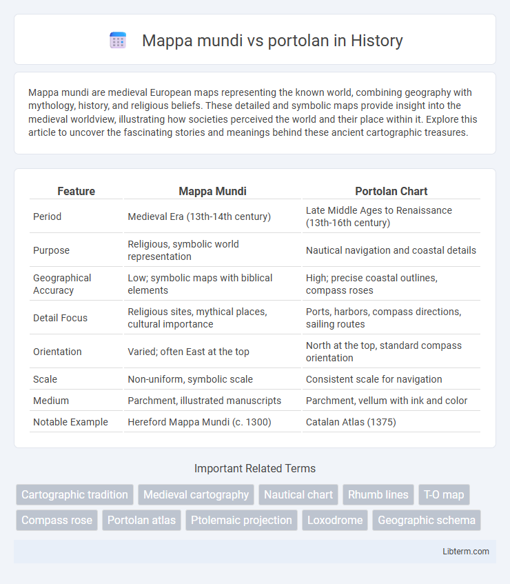
Table of Comparison
| Feature | Mappa Mundi | Portolan Chart |
|---|---|---|
| Period | Medieval Era (13th-14th century) | Late Middle Ages to Renaissance (13th-16th century) |
| Purpose | Religious, symbolic world representation | Nautical navigation and coastal details |
| Geographical Accuracy | Low; symbolic maps with biblical elements | High; precise coastal outlines, compass roses |
| Detail Focus | Religious sites, mythical places, cultural importance | Ports, harbors, compass directions, sailing routes |
| Orientation | Varied; often East at the top | North at the top, standard compass orientation |
| Scale | Non-uniform, symbolic scale | Consistent scale for navigation |
| Medium | Parchment, illustrated manuscripts | Parchment, vellum with ink and color |
| Notable Example | Hereford Mappa Mundi (c. 1300) | Catalan Atlas (1375) |
Understanding the Mappa Mundi: Medieval World Maps
Mappa Mundi, medieval world maps, differ from portolan charts by emphasizing symbolic and religious elements over geographic accuracy, often depicting a circular or T-O layout centered on Jerusalem. These maps illustrate the medieval worldview with biblical and mythological references, reflecting spiritual and cultural contexts rather than navigational precision. Understanding Mappa Mundi involves recognizing their role in conveying medieval cosmology and theological knowledge rather than serving as practical tools for maritime navigation.
What Are Portolan Charts?
Portolan charts are highly detailed nautical maps developed in the 13th century, characterized by their precise coastal outlines and network of rhumb lines used for navigation. Unlike Mappa Mundi, which provide symbolic and religious representations of the world, portolan charts emphasize practical maritime routes based on compass directions and actual geographic features. These charts played a crucial role in medieval seafaring, enabling sailors to plot courses accurately across the Mediterranean and beyond.
Key Differences: Mappa Mundi vs Portolan Maps
Mappa Mundi maps, created predominantly during the medieval period, emphasize symbolic and religious representations of the world, often featuring biblical events and mythological creatures, whereas Portolan maps are navigational charts developed in the 13th and 14th centuries that prioritize accurate coastal outlines and maritime routes. Mappa Mundi typically lack precise scale and geographic accuracy, focusing instead on illustrating spiritual and cultural knowledge, while Portolan maps use compass roses and rhumb lines to guide sailors with precise bearings and distances. The key differences lie in their purpose: Mappa Mundi serve as educational and theological tools, whereas Portolan maps function as practical instruments for navigation and trade.
Historical Origins and Development
Mappa Mundi are medieval European maps that originated in the 5th to 15th centuries, primarily reflecting religious and mythological views of the world with Jerusalem often at the center. Portolan charts emerged in the 13th century Mediterranean, developed by sailors for practical navigation, featuring detailed coastlines, compass roses, and rhumb lines for accurate maritime guidance. The transition from Mappa Mundi to portolan charts marked a shift from symbolic and theological representation towards empirical and functional cartography driven by expanding trade and exploration.
Geographic Accuracy and Representation
Mappa mundi, medieval European maps, prioritize symbolic and religious representation, often depicting the world with Jerusalem at the center and mixing mythological elements, resulting in low geographic accuracy. Portolan charts, developed in the 13th century for maritime navigation, emphasize precise coastlines, compass directions, and scale, delivering high geographic accuracy for sea routes around the Mediterranean and Atlantic. The functional use of portolan charts contrasts with the illustrative and theological nature of mappa mundi, reflecting their different purposes in medieval society.
Artistic Styles and Symbolism
Mappa Mundi maps exhibit intricate medieval artistic styles rich in religious symbolism, often depicting biblical scenes, mythological creatures, and a symbolic representation of the world centered on Jerusalem. Portolan charts prioritize practical navigation with precise coastlines and compass roses, featuring minimalist decoration mainly limited to artistic embellishments of compass roses and rhumb lines. The contrast between Mappa Mundi's thematic, illustrative approach and Portolan's functional, detail-oriented style highlights their differing purposes in medieval cartography.
Navigation and Practical Uses
Mappa mundi maps primarily served symbolic and religious purposes, offering a worldview rather than practical navigation information, thus limiting their use for maritime travel. Portolan charts, created in the 13th and 14th centuries, provided accurate coastal outlines, compass roses, and rhumb lines essential for sailors to navigate Mediterranean and European waters efficiently. The detailed shorelines and navigational aids of portolan maps revolutionized seafaring, enabling precise route planning and real-time course adjustments.
Cultural and Religious Influences
Mappa Mundi maps often reflect medieval European cultural and religious worldviews, prominently featuring biblical events, Christian symbolism, and Jerusalem as the map's spiritual center. In contrast, portolan charts emphasize practical navigation with detailed coastlines and compass directions, focusing on maritime trade hubs without overt religious iconography. The cultural significance of Mappa Mundi lies in its didactic and theological message, while portolans prioritize empirical seafaring knowledge shaped by Mediterranean commerce.
Major Surviving Examples
Major surviving examples of Mappa Mundi include the Hereford Mappa Mundi, dating from the late 13th century, renowned for its vivid medieval worldview centered on religious and historical themes. Portolan charts like the Catalan Atlas (c. 1375) and the Carta Pisana (late 13th century) represent early nautical maps characterized by precise coastal details and compass rose networks essential for maritime navigation. These artifacts highlight the contrasting purposes and design principles between symbolic Mappa Mundi and function-driven portolan charts.
Legacy and Impact on Cartography
Mappa Mundi, exemplified by the Hereford and Ebstorf maps, preserved medieval European religious and cosmological worldviews, shaping early cartographic traditions with symbolic representations and conceptual geography. Portolan charts, emerging in the 13th century, revolutionized navigation by providing highly accurate coastal outlines and compass-based directions, significantly influencing maritime exploration and the Age of Discovery. The legacy of Mappa Mundi lies in its role as cultural artifacts reflecting medieval knowledge, while portolan maps established practical foundations for modern cartography and global trade routes.
Mappa mundi Infographic