Nautical charts provide detailed representations of maritime areas, including water depths, hazards, navigational aids, and coastline features crucial for safe navigation. Understanding how to read and interpret these charts can significantly enhance your ability to plan routes and avoid potential dangers at sea. Explore the rest of the article to learn essential tips and techniques for using nautical charts effectively.
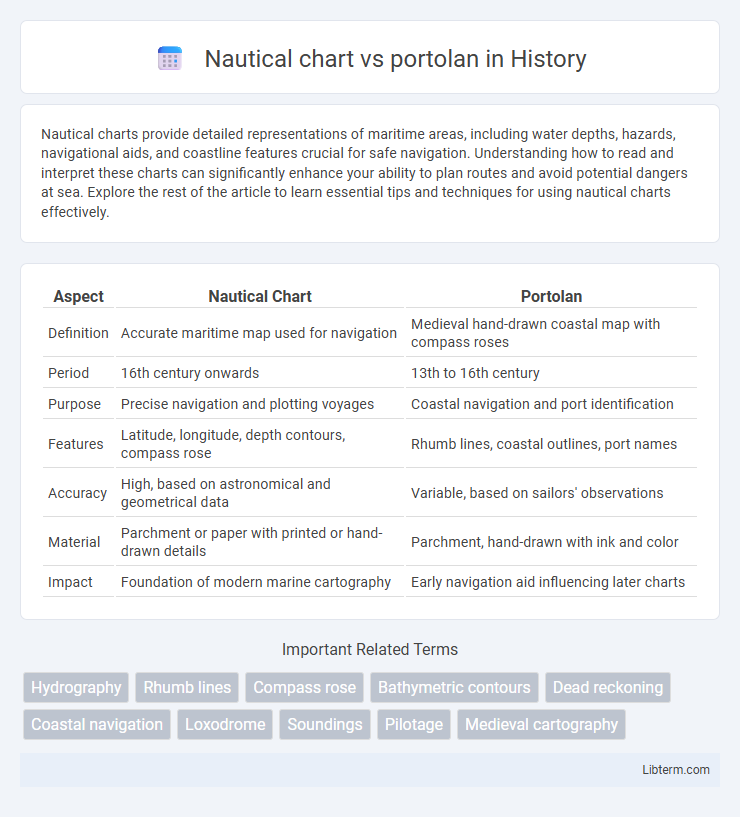
Table of Comparison
| Aspect | Nautical Chart | Portolan |
|---|---|---|
| Definition | Accurate maritime map used for navigation | Medieval hand-drawn coastal map with compass roses |
| Period | 16th century onwards | 13th to 16th century |
| Purpose | Precise navigation and plotting voyages | Coastal navigation and port identification |
| Features | Latitude, longitude, depth contours, compass rose | Rhumb lines, coastal outlines, port names |
| Accuracy | High, based on astronomical and geometrical data | Variable, based on sailors' observations |
| Material | Parchment or paper with printed or hand-drawn details | Parchment, hand-drawn with ink and color |
| Impact | Foundation of modern marine cartography | Early navigation aid influencing later charts |
Introduction to Nautical Charts and Portolan Charts
Nautical charts are detailed graphical representations of maritime areas, highlighting water depths, coastlines, navigational hazards, and aids such as buoys and lighthouses to ensure safe navigation. Portolan charts, originating in the 13th century, are early maritime maps renowned for their rhumb lines and precise coastal details, primarily used by Mediterranean sailors for route plotting. While nautical charts prioritize comprehensive hydrographic data for modern navigation, portolan charts emphasize coastal landmarks and compass directions, reflecting the historical evolution of marine cartography.
Historical Origins of Nautical and Portolan Charts
Nautical charts originated in ancient maritime cultures as practical tools for coastal navigation, evolving significantly during the Age of Exploration with increased accuracy and standardized symbols. Portolan charts, emerging in the 13th century Mediterranean, were among the earliest detailed maritime maps, characterized by their rhumb lines and compass roses used for precise coastal navigation. Both chart types played crucial roles in historical seafaring, with portolans influencing the development of more comprehensive nautical charts that integrated broader oceanic knowledge.
Key Features of Nautical Charts
Nautical charts provide precise, large-scale depictions of coastlines, depths, hazards, and navigational aids essential for safe maritime navigation, using standardized symbols and coordinate grids. These charts incorporate up-to-date hydrographic data, tidal information, and electronic overlays compatible with GPS and electronic chart display systems (ECDIS). In contrast, portolans are historical, hand-drawn maps emphasizing coastal outlines and compass roses without the comprehensive data or accuracy standards found in modern nautical charts.
Distinctive Elements of Portolan Charts
Portolan charts are distinguished by their intricate network of rhumb lines that radiate from compass roses, which facilitate precise maritime navigation by illustrating consistent wind directions. Unlike general nautical charts, portolans explicitly mark detailed coastal features, harbors, and sailing routes, often annotated with place names in a distinctive cursive script. Their handmade vellum production and emphasis on practical navigational use contrast with the broader topographic and hydrographic scope found in more modern nautical charts.
Purposes and Uses: Nautical Charts vs Portolans
Nautical charts serve as detailed maps designed for modern navigation, providing precise information about water depths, hazards, and aids to navigation essential for safe maritime travel. Portolans, originating in the medieval period, were hand-drawn coastal guides primarily used by sailors to navigate shorelines and identify ports based on compass directions and distances. While nautical charts prioritize technical accuracy and wide coverage in contemporary navigation systems, portolans emphasize practical coastal route guidance rooted in historical seafaring practices.
Cartographic Techniques and Materials
Nautical charts are created using precise cartographic techniques involving triangulation, stereographic projection, and hydrographic surveying to ensure accuracy in sea navigation. These charts are printed on durable, water-resistant materials like synthetic paper or coated vellum to withstand marine environments. In contrast, portolans are hand-drawn on parchment or vellum, utilizing compass roses and rhumb lines to depict coastal features without advanced surveying tools, reflecting their reliance on empirical observations and sailor reports.
Accuracy and Limitations in Navigation
Nautical charts provide highly accurate, up-to-date representations of marine environments, incorporating precise depth measurements, navigational aids, and coastal features utilizing advanced surveying techniques and satellite data. Portolan charts, originating in the medieval period, offer less precision with hand-drawn coastlines and compass roses that primarily focused on coastal navigation and were limited in representing open seas or underwater hazards. While nautical charts support modern navigation through reliable depth contours and electronic integration, portolans are constrained by their historical context, limiting their effectiveness for comprehensive voyage planning and safe passage in complex maritime conditions.
Impact on Maritime Exploration
Nautical charts, with their accurate representations of coastlines, depths, and navigational hazards, revolutionized maritime exploration by enabling precise route planning and safer long-distance voyages. Portolans, early navigational maps emphasizing coastal outlines and compass roses, facilitated Mediterranean and European sea travel in the 13th to 16th centuries but lacked the detailed hydrographic information of later nautical charts. The transition from portolan charts to more advanced nautical charts dramatically expanded maritime exploration, supporting the Age of Discovery and global navigation advancements.
Modern Relevance and Legacy
Nautical charts remain essential for contemporary maritime navigation, providing precise, scaled representations of coastlines, depths, and hazards using GPS integration and sonar data for enhanced accuracy and safety. Portolans, originating in the medieval period, serve as historical artifacts that laid the foundation for modern cartography with their detailed coastal outlines and compass rose navigation aids. Their legacy endures in today's electronic navigational systems, preserving the tradition of coastal charting while evolving through technological advancements.
Conclusion: Comparing Nautical and Portolan Charts
Nautical charts and portolan charts serve distinct navigational purposes, with nautical charts providing precise, standardized data crucial for modern maritime navigation, including depth soundings, hazards, and GPS coordinates. Portolan charts, historically significant, emphasize coastal outlines and compass rose bearings for Mediterranean sea routes, relying on visual landmarks rather than exact measurements. Comparing both highlights nautical charts' technological precision and global applicability versus portolan charts' artistic detail and regional navigation focus.
Nautical chart Infographic