Floodplains are low-lying areas adjacent to rivers and streams that regularly experience flooding, providing essential ecosystems that support diverse wildlife and natural water filtration. Understanding floodplain dynamics helps you mitigate risks to property and optimize land use planning for sustainable development. Explore the full article to discover how floodplains impact your environment and what measures you can take to protect your community.
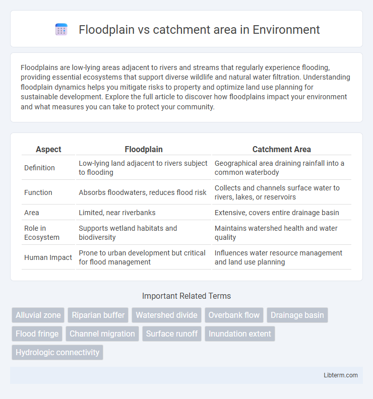
Table of Comparison
| Aspect | Floodplain | Catchment Area |
|---|---|---|
| Definition | Low-lying land adjacent to rivers subject to flooding | Geographical area draining rainfall into a common waterbody |
| Function | Absorbs floodwaters, reduces flood risk | Collects and channels surface water to rivers, lakes, or reservoirs |
| Area | Limited, near riverbanks | Extensive, covers entire drainage basin |
| Role in Ecosystem | Supports wetland habitats and biodiversity | Maintains watershed health and water quality |
| Human Impact | Prone to urban development but critical for flood management | Influences water resource management and land use planning |
Understanding Floodplains: Definition and Features
Floodplains are flat or gently sloping areas adjacent to rivers and streams that experience periodic flooding, characterized by nutrient-rich soils and diverse ecosystems. They function as natural buffers by absorbing excess water during heavy rainfall, reducing downstream flood risks. Understanding floodplain dynamics is crucial for effective land use planning and flood management within broader catchment areas.
What is a Catchment Area? Key Concepts Explained
A catchment area refers to the geographic region where all precipitation converges to a single point, typically a river, lake, or reservoir, influencing water flow and availability. It encompasses the entire drainage basin, including tributaries and land surfaces, playing a crucial role in hydrology and watershed management. Unlike a floodplain, which is the flat land adjacent to a river prone to flooding, the catchment area determines the quantity and movement of water feeding into the river system.
Geographic Differences Between Floodplain and Catchment Area
Floodplains are low-lying areas adjacent to rivers or streams that experience periodic flooding, characterized by sediment deposition and fertile soils. Catchment areas, also known as drainage basins, encompass a larger geographic region where all precipitation converges toward a common outlet such as a river, lake, or ocean. While floodplains represent a localized zone within a catchment, catchments cover extensive landscapes influencing hydrological processes and water flow patterns.
Hydrological Functions: Floodplain vs Catchment Area
Floodplains act as natural buffers by absorbing excess water during floods, reducing peak flow and promoting groundwater recharge, which mitigates downstream flooding. Catchment areas collect precipitation and channel surface runoff to rivers and streams, determining the volume and timing of water flow within a watershed. Both zones contribute to hydrological regulation but operate at different scales, with floodplains managing localized flood storage and catchments controlling broader water inputs and drainage patterns.
Ecological Roles of Floodplains and Catchment Areas
Floodplains serve as critical natural buffers by absorbing excess floodwater, reducing erosion, and providing habitats for diverse flora and fauna, which enhances biodiversity and supports nutrient cycling. Catchment areas collect and channel precipitation runoff into rivers and lakes, influencing water quality and availability, and maintaining hydrological balance across ecosystems. Together, floodplains and catchment areas regulate water flow, support aquatic and terrestrial habitats, and contribute to the resilience of natural landscapes against environmental changes.
Flood Risk: How Floodplains and Catchment Areas Interact
Floodplains, low-lying areas adjacent to rivers, act as natural buffers during heavy rainfall by temporarily storing excess water, significantly reducing flood risk downstream. Catchment areas, the land regions draining into a river system, influence flood risk by controlling the volume and rate of runoff entering rivers and floodplains. Efficient management of catchment areas and preservation of floodplains are critical to mitigating flood risk and enhancing water retention capacity in flood-prone regions.
Land Use Planning within Floodplains and Catchment Areas
Floodplain land use planning prioritizes flood risk management by restricting development in areas prone to inundation to minimize property damage and ensure public safety. Catchment area planning focuses on managing surface runoff, erosion control, and maintaining water quality by regulating land uses such as agriculture, urbanization, and forestry to protect downstream water bodies. Integrating floodplain and catchment area management supports sustainable development, enhances flood resilience, and preserves ecological functions within hydrologically connected regions.
Floodplain Management Strategies vs Catchment Management
Floodplain management strategies focus on controlling and mitigating flood risks by regulating land use, enhancing natural vegetation, and constructing flood defenses within flood-prone areas. Catchment management emphasizes integrated water resource planning across the entire drainage basin, addressing upstream activities to reduce erosion, sedimentation, and water pollution that impact downstream floodplains. Effective flood risk reduction requires coordinated efforts combining localized floodplain interventions with broader catchment-scale environmental management.
Real-World Examples of Floodplains and Catchment Areas
The Mississippi River floodplain in the United States exemplifies a vast area prone to seasonal flooding, supporting diverse ecosystems and agriculture. The Amazon River catchment area spans approximately 7 million square kilometers, collecting rainfall and tributaries that feed the world's largest tropical rainforest. In Australia, the Murray-Darling Basin illustrates a critical catchment area where water management directly impacts floodplains and regional water resources.
Comparative Summary: Floodplain vs Catchment Area
Floodplains are low-lying areas adjacent to rivers that experience periodic flooding, playing a crucial role in natural water storage and habitat diversity. Catchment areas, also known as drainage basins, encompass the entire geographical region from which rainfall and surface runoff flow into a specific river or reservoir, influencing water availability and watershed management. While floodplains directly manage excess water during floods, catchment areas determine the overall water input and distribution across a wider landscape.
Floodplain Infographic