A river basin is a land area drained by a river and its tributaries, playing a crucial role in water collection and distribution. Managing river basins effectively supports agriculture, biodiversity, and human settlements by ensuring sustainable water supply and flood control. Discover how understanding your local river basin can impact environmental planning and resource management in the full article.
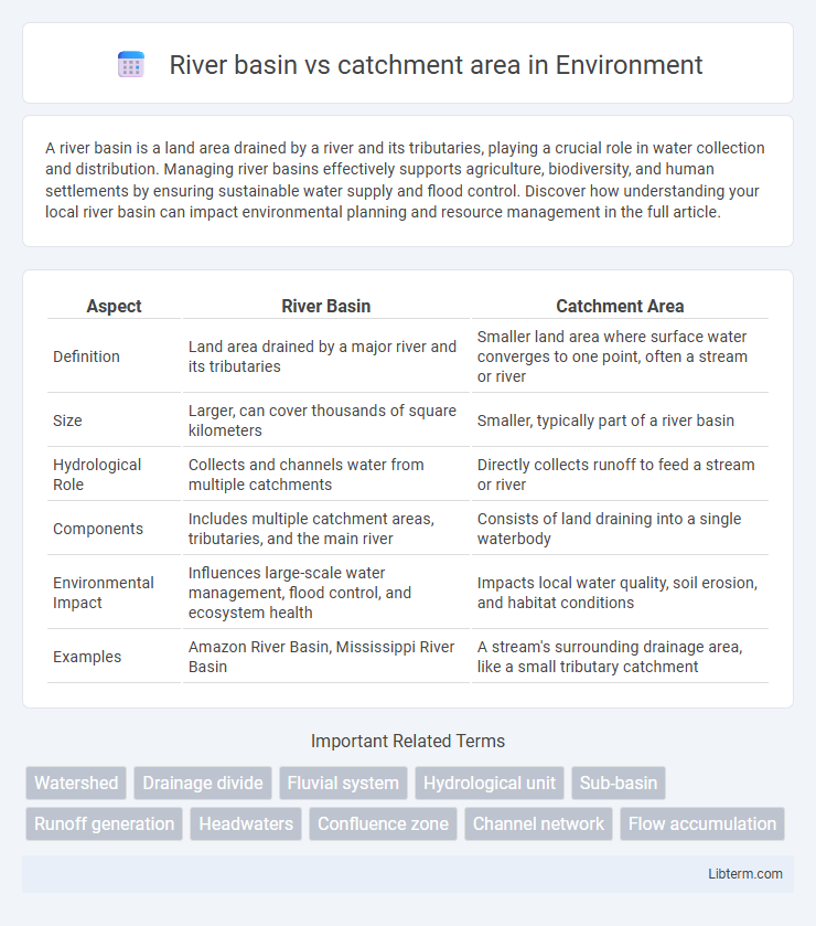
Table of Comparison
| Aspect | River Basin | Catchment Area |
|---|---|---|
| Definition | Land area drained by a major river and its tributaries | Smaller land area where surface water converges to one point, often a stream or river |
| Size | Larger, can cover thousands of square kilometers | Smaller, typically part of a river basin |
| Hydrological Role | Collects and channels water from multiple catchments | Directly collects runoff to feed a stream or river |
| Components | Includes multiple catchment areas, tributaries, and the main river | Consists of land draining into a single waterbody |
| Environmental Impact | Influences large-scale water management, flood control, and ecosystem health | Impacts local water quality, soil erosion, and habitat conditions |
| Examples | Amazon River Basin, Mississippi River Basin | A stream's surrounding drainage area, like a small tributary catchment |
Introduction: Defining River Basin and Catchment Area
A river basin is a large geographical area drained by a major river and all its tributaries, encompassing multiple catchment areas within its extent. A catchment area, or drainage basin, is a specific land region where precipitation collects and drains into a particular river, stream, or lake. Understanding the differences between river basins and catchment areas is essential for effective water resource management and environmental planning.
Geographical Scope: Comparing Sizes and Boundaries
River basins encompass extensive geographical areas drained by a river and all its tributaries, often spanning multiple states or countries. Catchment areas, by contrast, are smaller subdivisions within a river basin, defined as the land area where precipitation collects and drains into a specific stream or river segment. The boundaries of river basins are determined by watershed divides that include all tributaries, while catchment area boundaries are more localized, linked to individual watercourses.
Key Hydrological Differences
A river basin encompasses the entire geographical area drained by a river and its tributaries, while a catchment area refers specifically to the smaller region where precipitation collects and flows into a single stream or river segment. Key hydrological differences include the scale of water flow management, with river basins involving complex networks affecting multiple catchments, influencing larger-scale water redistribution and flood control. In contrast, catchment areas focus on localized runoff generation, soil infiltration, and immediate water quality impacts.
Components and Features of a River Basin
A river basin encompasses the entire geographical area drained by a river and its tributaries, including surface water, groundwater, and all sub-catchments within the boundary. Key components of a river basin include the main river channel, tributaries, floodplains, aquifers, and watershed divides that direct precipitation and runoff towards the river system. Features such as drainage density, area of the basin, slope, soil type, and vegetation cover influence water flow patterns, sediment transport, and the overall hydrological response within the river basin.
Components and Features of a Catchment Area
A catchment area, also known as a drainage basin, is a land region where all precipitation collects and flows into a single river, lake, or reservoir. Key components include watershed boundaries defined by high points or divides, tributary networks channeling water, and surface features like soil type, vegetation, and slope influencing runoff and infiltration. Features such as storage elements (lakes, wetlands), human-made structures (dams, reservoirs), and groundwater recharge zones play critical roles in regulating hydrological processes within the catchment.
Importance in Water Resource Management
River basins and catchment areas play crucial roles in water resource management by defining the spatial extent for water flow collection and distribution. Effective management of these hydrological units supports flood control, water quality maintenance, and sustainable groundwater recharge, ensuring optimized water availability for agriculture, industry, and human consumption. Understanding the scale and characteristics of river basins and catchment areas aids in implementing integrated watershed management practices and enhancing resilience to climate variability.
Environmental Impact and Biodiversity
River basins, encompassing entire drainage networks, support diverse ecosystems by maintaining hydrological connectivity vital for species migration and nutrient cycling, whereas catchment areas, as smaller subdivisions, influence localized water quality and habitat conditions. Environmental impacts in river basins often include large-scale issues such as sedimentation, pollution, and habitat fragmentation, which can disrupt biodiversity across multiple ecosystems. Effective management of both river basins and catchment areas is crucial to preserving aquatic biodiversity, controlling invasive species, and sustaining ecological services essential for environmental health.
Role in Flood Control and Mitigation
River basins and catchment areas are critical in flood control and mitigation by managing surface water flow and storage capacity. River basins, encompassing multiple catchment areas, regulate large-scale water discharge through integrated watershed management, reducing flood risks downstream. Catchment areas focus on localized water collection and infiltration, enabling targeted flood prevention through natural retention and engineered structures.
Global Examples of River Basins and Catchment Areas
The Amazon River Basin, spanning approximately 7 million square kilometers across South America, exemplifies the vast scale of a river basin, encompassing multiple catchment areas that drain into its tributaries. In contrast, the Thames River Catchment in England covers about 12,935 square kilometers, illustrating a smaller, localized catchment area feeding into a single river system. Globally, river basins like the Nile and Mississippi integrate numerous catchment areas, highlighting the hierarchical relationship where catchments contribute to larger basin networks critical for water resource management.
Conclusion: Choosing the Right Term for Context
Selecting between "river basin" and "catchment area" depends on the spatial scale and hydrological focus of the study. A river basin refers to the entire geographical area draining into a major river and its tributaries, while a catchment area typically denotes a smaller, localized drainage zone. Using the correct term enhances clarity in water resource management, environmental planning, and scientific communication.
River basin Infographic