Remote sensing technology captures data about Earth's surface without direct contact, using satellite or aerial sensors to monitor environmental changes, urban development, and natural disasters. This powerful method enables precise mapping and timely analysis of vast areas, helping researchers and policymakers make informed decisions. Explore the rest of the article to understand how remote sensing can enhance your approach to observing and managing the planet.
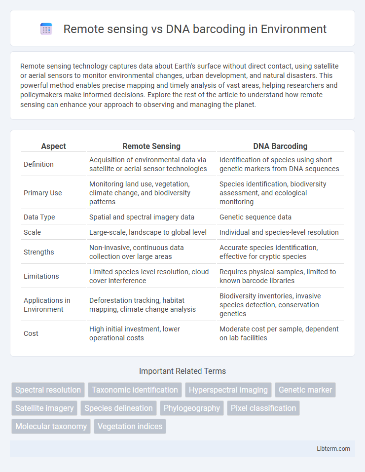
Table of Comparison
| Aspect | Remote Sensing | DNA Barcoding |
|---|---|---|
| Definition | Acquisition of environmental data via satellite or aerial sensor technologies | Identification of species using short genetic markers from DNA sequences |
| Primary Use | Monitoring land use, vegetation, climate change, and biodiversity patterns | Species identification, biodiversity assessment, and ecological monitoring |
| Data Type | Spatial and spectral imagery data | Genetic sequence data |
| Scale | Large-scale, landscape to global level | Individual and species-level resolution |
| Strengths | Non-invasive, continuous data collection over large areas | Accurate species identification, effective for cryptic species |
| Limitations | Limited species-level resolution, cloud cover interference | Requires physical samples, limited to known barcode libraries |
| Applications in Environment | Deforestation tracking, habitat mapping, climate change analysis | Biodiversity inventories, invasive species detection, conservation genetics |
| Cost | High initial investment, lower operational costs | Moderate cost per sample, dependent on lab facilities |
Introduction to Remote Sensing and DNA Barcoding
Remote sensing involves the acquisition of information about objects or areas from a distance, typically using satellite or aerial sensor technologies that capture data on land cover, vegetation, and environmental changes. DNA barcoding is a molecular technique that utilizes short, standardized gene regions, such as the mitochondrial COI gene, to accurately identify and classify species based on genetic sequences. Both methods provide complementary tools for biodiversity assessment and monitoring, with remote sensing offering large-scale spatial data and DNA barcoding providing precise species-level identification.
Core Principles of Remote Sensing
Remote sensing relies on the detection and measurement of electromagnetic radiation reflected or emitted from surfaces to gather data about the Earth's environment without direct contact. It employs sensors on satellites or aircraft to capture spatial and spectral information, enabling the analysis of land cover, vegetation health, and environmental changes. Unlike DNA barcoding, which identifies species through genetic sequences, remote sensing provides large-scale, real-time observations crucial for ecological monitoring and resource management.
Fundamental Concepts of DNA Barcoding
DNA barcoding relies on analyzing short, standardized genetic markers, typically mitochondrial COI sequences, to accurately identify species by comparing them against a reference database. Unlike remote sensing, which uses aerial or satellite imagery to capture environmental and spatial data, DNA barcoding provides precise species-level identification through molecular techniques. This approach enhances biodiversity assessment and ecological studies by enabling rapid, cost-effective, and reliable detection of organisms, even from small or degraded samples.
Key Technologies in Remote Sensing
Remote sensing employs satellite imagery, LiDAR, and hyperspectral sensors to collect spatial and spectral data for environmental monitoring and biodiversity assessment. These technologies enable large-scale, non-invasive data acquisition with high temporal resolution, facilitating habitat mapping, species distribution analysis, and ecosystem health evaluation. Unlike DNA barcoding, which relies on genetic sequencing for species identification, remote sensing focuses on landscape-level patterns and environmental variables critical for ecological research and conservation planning.
Essential Techniques in DNA Barcoding
DNA barcoding relies on essential techniques such as polymerase chain reaction (PCR) amplification, sequencing of standardized gene regions like the mitochondrial COI gene, and bioinformatics analysis for species identification and comparison. These techniques enable rapid and accurate detection of biodiversity at the molecular level, complementing remote sensing's large-scale ecological data collection. While remote sensing captures environmental and spatial information, DNA barcoding provides precise genetic identification essential for taxonomy, conservation, and ecological studies.
Applications in Environmental Monitoring
Remote sensing enables large-scale environmental monitoring by capturing spatial and temporal data on vegetation health, land use changes, and ecosystem dynamics through satellite or drone imagery. DNA barcoding complements this by providing precise species identification and biodiversity assessments in ecosystems, enhancing conservation strategies and detecting invasive species. Combining remote sensing with DNA barcoding offers a comprehensive approach to ecosystem monitoring, improving accuracy in tracking habitat changes and species distribution.
Comparative Accuracy and Resolution
Remote sensing offers high spatial resolution for large-scale environmental monitoring but may lack species-level specificity, whereas DNA barcoding provides precise taxonomic accuracy by identifying organisms based on genetic sequences. Remote sensing can rapidly assess ecosystem patterns and biodiversity distribution over vast areas, while DNA barcoding excels in distinguishing cryptic species and verifying species identity with molecular-level resolution. Combining remote sensing data with DNA barcoding results enhances overall biodiversity assessment by balancing broad spatial coverage with fine taxonomic accuracy.
Cost Efficiency and Accessibility
Remote sensing offers cost efficiency through large-scale, non-invasive data collection, enabling rapid monitoring of ecosystems without extensive fieldwork expenses. DNA barcoding, while highly accurate for species identification, often incurs higher costs due to laboratory analysis, specialized equipment, and expert personnel requirements. Accessibility to remote sensing technologies has increased with advances in satellite and drone systems, whereas DNA barcoding remains limited by the need for molecular biology facilities and trained technicians.
Strengths and Limitations of Each Method
Remote sensing excels in large-scale environmental monitoring by capturing spatial and temporal data across vast landscapes but often lacks species-specific resolution and is limited by atmospheric conditions. DNA barcoding provides precise species identification through genetic markers, enabling accurate biodiversity assessments, yet it requires sample collection and can be hindered by incomplete reference databases or DNA degradation. Combining remote sensing with DNA barcoding enhances ecological studies by integrating broad habitat mapping with detailed taxonomic insights.
Integrative Approaches and Future Prospects
Remote sensing and DNA barcoding represent complementary integrative approaches in biodiversity assessment, where remote sensing provides large-scale habitat and ecosystem data while DNA barcoding offers precise species-level identification through genetic markers. Combining satellite or aerial imagery with molecular techniques enables more accurate monitoring of species distributions, ecosystem health, and environmental changes by linking spatial patterns with genetic diversity data. Future prospects emphasize advanced machine learning integration, real-time data fusion, and scalable frameworks that enhance conservation strategies and ecological research by leveraging both geospatial and genetic information.
Remote sensing Infographic