Regional climate shapes local ecosystems and influences weather patterns unique to specific geographic areas. Understanding these variations helps predict agricultural productivity, natural disaster risks, and biodiversity health. Explore the rest of the article to learn how your region's climate impacts daily life and long-term planning.
Table of Comparison
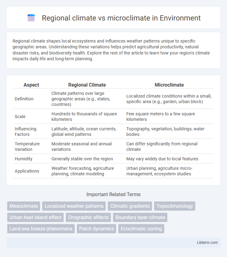
| Aspect | Regional Climate | Microclimate |
|---|---|---|
| Definition | Climate patterns over large geographic areas (e.g., states, countries) | Localized climate conditions within a small, specific area (e.g., garden, urban block) |
| Scale | Hundreds to thousands of square kilometers | Few square meters to a few square kilometers |
| Influencing Factors | Latitude, altitude, ocean currents, global wind patterns | Topography, vegetation, buildings, water bodies |
| Temperature Variation | Moderate seasonal and annual variations | Can differ significantly from regional climate |
| Humidity | Generally stable over the region | May vary widely due to local features |
| Applications | Weather forecasting, agriculture planning, climate modeling | Urban planning, agriculture micro-management, ecosystem studies |
Defining Regional Climate and Microclimate
Regional climate describes the long-term weather patterns and atmospheric conditions of a broad geographic area influenced by factors such as latitude, altitude, and prevailing winds. Microclimate refers to the localized climate of a specific, smaller area, often affected by factors like terrain, vegetation, buildings, and water bodies that create distinct temperature, humidity, and wind patterns. Understanding regional climate provides context for climatic trends over large scales, while microclimate analysis is essential for assessing environmental conditions in specific habitats or urban settings.
Geographical Scale: Regional vs Local Factors
Regional climate encompasses broad atmospheric patterns determined by large-scale geographical features such as latitude, altitude, and ocean currents, influencing temperature and precipitation over extensive areas. Microclimate refers to localized climate conditions shaped by specific factors like topography, vegetation, and urban infrastructure, which create variations within a small area, sometimes just a few meters. Understanding the distinction between regional climate and microclimate is essential for accurately assessing environmental conditions and planning in fields such as agriculture, urban development, and ecology.
Key Influences on Regional Climate Patterns
Regional climate patterns are primarily influenced by factors such as latitude, altitude, prevailing wind systems, and proximity to large water bodies, which regulate temperature and precipitation over broad areas. Mountain ranges and ocean currents further modify these conditions, creating distinct climatic zones like Mediterranean, continental, or maritime climates. Human activities such as urbanization and deforestation increasingly alter regional climate by affecting surface albedo and greenhouse gas concentrations.
Microclimate Drivers: Urban, Vegetation, and Topography
Microclimate drivers such as urbanization, vegetation, and topography play a crucial role in shaping localized climatic conditions distinct from broader regional climates. Urban areas often experience elevated temperatures due to heat retention by buildings and pavement, known as the urban heat island effect, while vegetation contributes to cooling through shading and evapotranspiration. Topography influences microclimates by affecting airflow, sunlight exposure, and moisture distribution, creating diverse temperature and humidity patterns within small geographic areas.
Temporal Variability in Regional and Microclimates
Regional climate exhibits temporal variability over extended periods, influenced by large-scale atmospheric patterns and seasonal cycles, leading to predictable fluctuations such as monsoon seasons or temperature shifts across decades. Microclimates demonstrate more immediate and localized temporal variability, affected by factors like topography, vegetation, and urban structures that cause rapid changes within hours or days. Understanding these temporal dynamics is crucial for accurate climate modeling, agricultural planning, and urban development strategies tailored to both broader regional trends and specific micro-environmental conditions.
The Role of Water Bodies in Shaping Local Climate
Water bodies significantly influence local microclimates by moderating temperature fluctuations through their high heat capacity, absorbing heat slowly and releasing it gradually. This thermal regulation creates milder winters and cooler summers in nearby areas compared to the broader regional climate, which is dictated by larger atmospheric patterns. Coastal and lake-adjacent regions often experience increased humidity and localized wind patterns, further distinguishing microclimate conditions from the prevailing regional climate.
Human Activities and Microclimate Alterations
Human activities such as urbanization, deforestation, and industrial operations drastically alter microclimates by modifying land surfaces, increasing heat absorption, and affecting local airflow patterns. These microclimate alterations can create urban heat islands with temperature variations significantly different from the surrounding regional climate. Understanding the impact of human-induced changes on microclimates is essential for urban planning and mitigating adverse environmental and health effects.
Ecological Impacts of Microclimate Differences
Microclimates create unique ecological niches by influencing temperature, humidity, and sunlight exposure on a localized scale, which can significantly affect species distribution and biodiversity. These localized variations impact plant growth patterns, animal behavior, and soil composition, leading to diverse microhabitats within broader regional climates. Understanding microclimate differences is crucial for habitat conservation, as it helps predict ecosystem responses to environmental changes and guides effective management strategies.
Climate Data Collection: Tools and Techniques
Regional climate data is primarily gathered through extensive tools such as weather stations, satellites, and long-term meteorological databases, providing broad-scale temperature, precipitation, and wind patterns over large areas. Microclimate analysis relies on localized instruments like data loggers, soil moisture sensors, and portable weather stations to capture detailed variations in temperature, humidity, and solar radiation within small, specific environments. Advanced techniques including remote sensing, geographic information systems (GIS), and climate modeling enhance the precision and spatial resolution of both regional and microclimate data collection, enabling comprehensive environmental assessments.
Applications: Urban Planning and Agriculture
Regional climate data guides urban planners in designing infrastructure resilient to temperature extremes, precipitation patterns, and seasonal variations, while microclimate analysis informs localized interventions like green roofs and shading to mitigate urban heat islands. In agriculture, understanding regional climate helps determine crop suitability and planting schedules over large areas, whereas microclimate monitoring allows farmers to optimize irrigation, pest control, and frost protection at a field or orchard level. Integrating both scales improves resource efficiency, crop yield, and urban comfort by tailoring strategies to broad trends and site-specific conditions.
Regional climate Infographic