Floodplains are flat areas adjacent to rivers and streams that become submerged during periods of high water flow, playing a crucial role in natural water management and ecosystem health. These areas act as natural buffers, absorbing excess water to reduce flooding risks while supporting diverse wildlife habitats. Discover how understanding floodplains can help you better protect your property and the environment by reading the full article.
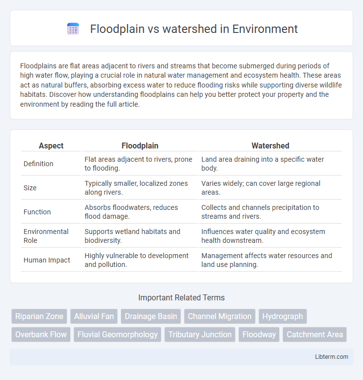
Table of Comparison
| Aspect | Floodplain | Watershed |
|---|---|---|
| Definition | Flat areas adjacent to rivers, prone to flooding. | Land area draining into a specific water body. |
| Size | Typically smaller, localized zones along rivers. | Varies widely; can cover large regional areas. |
| Function | Absorbs floodwaters, reduces flood damage. | Collects and channels precipitation to streams and rivers. |
| Environmental Role | Supports wetland habitats and biodiversity. | Influences water quality and ecosystem health downstream. |
| Human Impact | Highly vulnerable to development and pollution. | Management affects water resources and land use planning. |
Introduction to Floodplain and Watershed
A floodplain is a flat area of land adjacent to a river or stream that experiences periodic flooding, providing critical habitats and natural flood storage. A watershed, also known as a drainage basin, is the land area that channels rainfall and snowmelt to creeks, streams, and rivers, eventually leading to larger bodies of water. Understanding the interrelationship between floodplains and watersheds is essential for effective water resource management and flood risk mitigation.
Defining a Floodplain
A floodplain is a flat or nearly flat land area adjacent to a river or stream that experiences occasional or periodic flooding, characterized by its ability to absorb excess water during high flow events. Watersheds, by contrast, are larger geographic areas that drain rainfall and snowmelt into a common outlet such as a river, bay, or other body of water, encompassing multiple floodplains within their boundaries. Defining a floodplain involves identifying the low-lying terrain directly impacted by floodwaters, critical for flood risk management, ecological health, and land-use planning.
Understanding the Watershed Concept
A watershed, also known as a drainage basin, is an area of land where all precipitation collects and drains into a common outlet such as a river, lake, or ocean, playing a critical role in managing water flow and quality. Floodplains are flat areas adjacent to rivers within a watershed that temporarily store excess water during flooding, reducing downstream flood risk. Understanding the watershed concept is essential for effective water resource management, flood control, and environmental protection strategies.
Key Differences Between Floodplain and Watershed
A floodplain is a flat area adjacent to a river or stream that experiences flooding during periods of high discharge, while a watershed is a land area that channels rainfall and snowmelt to creeks, streams, and rivers, ultimately draining into a common outlet. Floodplains primarily function as natural flood buffers, reducing damage during high water events, whereas watersheds serve as hydrological units that manage the collection and flow of water across a landscape. The key difference lies in scale and function: floodplains are localized zones susceptible to flooding, whereas watersheds encompass the entire drainage basin influencing water movement and resource management.
Importance in Water Management
Floodplains play a crucial role in water management by absorbing excess floodwaters, reducing downstream flooding risks, and improving groundwater recharge. Watersheds serve as fundamental hydrological units that collect and channel precipitation to common outlets, enabling effective management of water resources, pollution control, and ecosystem health. Understanding both floodplain dynamics and watershed boundaries is essential for integrated water management strategies to sustainably balance flood mitigation, water supply, and habitat conservation.
Environmental Impact of Floodplains
Floodplains serve as natural buffers by absorbing excess water during heavy rainfall, reducing the risk of downstream flooding and protecting ecosystems within watersheds. These areas support diverse habitats, improve water quality by filtering pollutants, and recharge groundwater supplies, enhancing overall watershed health. Disruption or development of floodplains can lead to increased flood severity, habitat loss, and compromised water resources in the watershed.
Ecological Role of Watersheds
Watersheds play a crucial ecological role by collecting precipitation and channeling it through rivers and streams, supporting diverse habitats and maintaining water quality. They regulate nutrient cycling and sediment transport, which sustains aquatic ecosystems and controls floodplain fertility. Effective watershed management promotes biodiversity, reduces pollution, and mitigates flood risks within connected floodplain environments.
Floodplain vs Watershed: Risk and Mitigation
Floodplains are low-lying areas adjacent to rivers prone to flooding, while watersheds are land areas that channel rainfall into streams and rivers, influencing flood risks downstream. Effective risk mitigation involves managing floodplain development to reduce exposure and implementing watershed-scale strategies like reforestation and sustainable land use to control runoff. Understanding the interplay between floodplains and watersheds is crucial for comprehensive flood risk management and disaster resilience planning.
Human Activities and Their Effects
Human activities such as urban development and deforestation within floodplains increase the risk of flooding by reducing natural water absorption and altering drainage patterns. Watershed management practices, including agriculture and industrial runoff, significantly affect water quality and sediment loads, impacting downstream ecosystems and floodplain health. Effective regulation and restoration efforts in both floodplains and watersheds are crucial to mitigating adverse impacts on hydrology and biodiversity.
Summary: Choosing the Right Approach
Floodplain management focuses on areas adjacent to rivers and streams prone to flooding, prioritizing flood risk reduction and land use regulation. Watershed management considers the entire drainage basin, emphasizing water quality, ecosystem health, and resource sustainability across interconnected land and water systems. Selecting the right approach depends on objectives, with floodplain strategies targeting immediate flood risks and watershed approaches supporting long-term environmental and hydrological balance.
Floodplain Infographic