Gully erosion occurs when water runoff rapidly removes soil along natural drainage paths, creating deep channels that degrade land quality and reduce agricultural productivity. Managing gullies involves a combination of vegetation planting, constructing barriers, and improving land drainage to prevent further soil loss and environmental damage. Explore the rest of the article to learn how you can effectively control gully erosion and restore your land's health.
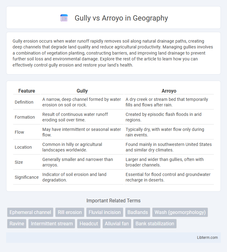
Table of Comparison
| Feature | Gully | Arroyo |
|---|---|---|
| Definition | A narrow, deep channel formed by water erosion on soil or rock. | A dry creek or stream bed that temporarily fills and flows after rain. |
| Formation | Result of continuous water runoff eroding soil over time. | Created by episodic flash floods in arid regions. |
| Flow | May have intermittent or seasonal water flow. | Typically dry, with water flow only during rain events. |
| Location | Common in hilly or agricultural landscapes worldwide. | Found mainly in southwestern United States and similar dry climates. |
| Size | Generally smaller and narrower than arroyos. | Larger and wider than gullies, often with broader channels. |
| Significance | Indicator of soil erosion and land degradation. | Essential for flood control and groundwater recharge in deserts. |
Introduction to Gullies and Arroyos
Gullies are narrow, steep-sided channels formed by the concentrated flow of surface water, often resulting from soil erosion after heavy rainfall. Arroyos, typically found in arid and semi-arid regions, are dry creek beds that temporarily fill with water after intense storms, shaping the landscape through intermittent flood events. Both landforms play crucial roles in water runoff management and sediment transport in their respective environments.
Defining Gullies: Key Characteristics
Gullies are deep, narrow channels formed by intense water erosion, typically resulting from heavy rainfall or surface runoff that removes soil and sediment rapidly. They are characterized by steep sides, a well-defined bed, and a significant depth that distinguishes them from smaller rills or ephemeral stream channels. Unlike arroyos, gullies often develop gradually through repeated erosion processes and may not necessarily be dry, making them critical indicators of soil degradation in agricultural and semi-arid regions.
Defining Arroyos: Key Features
Arroyos are dry creek beds or gullies that temporarily fill with water during heavy rainfall, characterized by steep banks and a defined channel. These ephemeral watercourses serve as natural drainage systems in arid and semi-arid regions, supporting rapid runoff and reducing soil erosion. Their sandy or rocky substrates differ from typical gullies, which may form through prolonged erosion and vegetation loss.
Formation Processes: Gullies vs Arroyos
Gullies form primarily through the concentrated flow of water during heavy rainfall, which erodes soil and creates narrow channels typically found in agricultural or deforested areas. Arroyos develop mainly in arid and semi-arid regions as dry creek beds that experience sudden, intense flash floods, carving deeper and wider channels compared to gullies. Both features result from water erosion but differ in scale, climate conditions, and the episodic nature of their formation processes.
Geographical Occurrence and Distribution
Gullies commonly form in arid and semi-arid regions due to intense surface runoff, prominently appearing in agricultural landscapes and hilly terrains worldwide. Arroyos, often found in the southwestern United States and northern Mexico, are dry creek beds that temporarily fill with water following heavy rains, shaped by flash flooding in desert climates. The geographical distribution of gullies spans multiple continents, while arroyos are specifically tied to desert and semi-desert environments characterized by sporadic but intense precipitation events.
Environmental Impact and Significance
Gullies contribute significantly to soil erosion by channeling concentrated water flow, often leading to habitat destruction and sedimentation in downstream water bodies. Arroyos, typically dry creek beds found in arid regions, serve as natural drainage pathways that can rapidly transmit runoff during rainfall, influencing local water cycles and recharge rates. Both landforms play critical roles in shaping watershed dynamics, affecting biodiversity, sediment transport, and landscape stability.
Erosion and Sedimentation Differences
Gullies are deep, narrow channels formed primarily by concentrated surface water erosion, often resulting in significant sediment displacement and landscape alteration. Arroyos, typically found in arid regions, are dry creek beds or stream channels that experience episodic water flow, causing both erosion of channel walls and sediment deposition downstream. The key difference lies in their formation dynamics: gullies progressively deepen due to consistent erosion, while arroyos are shaped by intermittent flow events leading to alternating erosion and sedimentation phases.
Human Activities and Land Use Impacts
Gullies and arroyos both result from intensified soil erosion influenced by human activities such as deforestation, overgrazing, and urban expansion that disturb natural land cover. Agricultural practices and construction increase surface runoff, exacerbating the deep incision and widening of gullies and arroyos, leading to significant landscape degradation. These erosion features disrupt local ecosystems, reduce arable land, and contribute to sedimentation in downstream water bodies, challenging sustainable land management efforts.
Management and Control Measures
Effective management of gullies involves soil conservation techniques such as regrading slopes, installing check dams, and planting vegetation to stabilize soil and reduce erosion. Arroyo control focuses on managing water flow through channelization, constructing retention basins, and employing sediment control structures to prevent flooding and sediment deposition. Both require integrated watershed management approaches to ensure long-term stability and minimize environmental impact.
Conclusion: Comparing Gullies and Arroyos
Gullies and arroyos both represent channels formed by water erosion but differ significantly in scale and environmental impact. Gullies are smaller, often shallow channels primarily caused by surface runoff, whereas arroyos are larger, deeper, and can carry substantial water flow, typically found in arid or semi-arid regions. Understanding these distinctions aids in effective land management and erosion control strategies in diverse ecosystems.
Gully Infographic