A basemap serves as the foundational layer for geographic data visualization, providing essential context such as roads, landmarks, and terrain. High-quality basemaps enhance spatial analysis by accurately representing the environment beneath your data points. Explore the full article to understand how choosing the right basemap can transform your map's effectiveness.
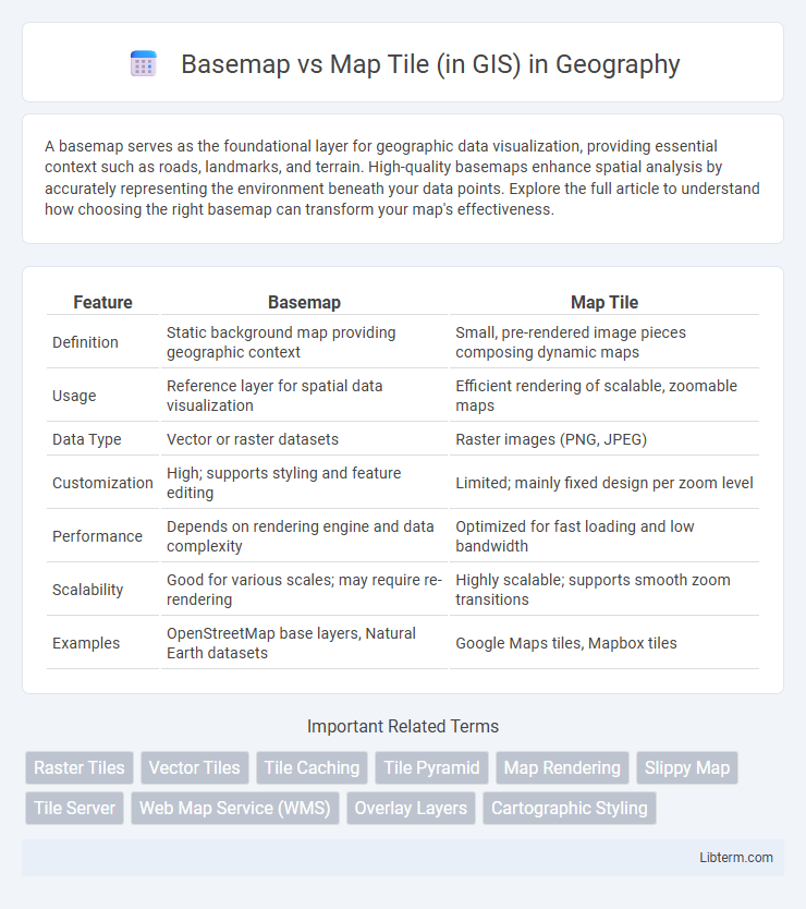
Table of Comparison
| Feature | Basemap | Map Tile |
|---|---|---|
| Definition | Static background map providing geographic context | Small, pre-rendered image pieces composing dynamic maps |
| Usage | Reference layer for spatial data visualization | Efficient rendering of scalable, zoomable maps |
| Data Type | Vector or raster datasets | Raster images (PNG, JPEG) |
| Customization | High; supports styling and feature editing | Limited; mainly fixed design per zoom level |
| Performance | Depends on rendering engine and data complexity | Optimized for fast loading and low bandwidth |
| Scalability | Good for various scales; may require re-rendering | Highly scalable; supports smooth zoom transitions |
| Examples | OpenStreetMap base layers, Natural Earth datasets | Google Maps tiles, Mapbox tiles |
Introduction to Basemaps and Map Tiles in GIS
Basemaps in GIS provide a foundational geographic context by displaying background information such as streets, terrain, or satellite imagery to support spatial analysis. Map tiles are small, pre-rendered image files that form a mosaic to efficiently deliver map data at various zoom levels and improve loading times. Together, basemaps and map tiles enable dynamic, scalable, and visually coherent map experiences in GIS applications.
Defining Basemaps: Purpose and Characteristics
Basemaps in GIS serve as foundational geographic layers providing spatial context for overlaying thematic data. They typically include features such as roads, rivers, land use, and political boundaries, designed for clear visualization and navigational reference. Unlike map tiles, which are discrete image segments retrieved dynamically, basemaps offer a continuous, cohesive background optimized for cartographic clarity and user orientation.
Explaining Map Tiles: Structure and Function
Map tiles are small, square images that collectively form a seamless, zoomable map when assembled in a grid pattern. Each tile corresponds to a specific geographic area and zoom level, enabling efficient loading and rendering by only fetching visible tiles. This structure supports rapid map interaction and scalability, making map tiles essential for dynamic web mapping and GIS applications.
Key Differences Between Basemaps and Map Tiles
Basemaps serve as foundational geographic layers providing context and reference such as roads, terrain, or satellite imagery, while map tiles are the individual image segments that compose these basemaps to enable efficient loading and rendering. Basemaps offer complete thematic backgrounds for spatial analysis, whereas map tiles optimize map performance by loading only necessary portions dynamically, reducing bandwidth and processing time. The key difference lies in basemaps representing coherent, thematic geographic overviews, and map tiles functioning as discrete, cached map images that ensure scalable, fast user interaction in Geographic Information Systems.
Role of Basemaps in GIS Applications
Basemaps in GIS applications serve as a foundational geographic framework that provides spatial context for overlaying thematic data, enabling accurate interpretation and analysis. They offer consistent reference layers such as satellite imagery, street maps, or topographic maps, which enhance visualization and spatial orientation across various GIS projects. The quality and detail of basemaps directly impact the precision of spatial analysis and decision-making processes by grounding dynamic data in real-world geography.
Map Tile Formats and Delivery Methods
Map Tile formats such as PNG, JPEG, and WebP facilitate efficient rendering and visual clarity in GIS applications, supporting various transparency and compression needs. Delivery methods primarily include XYZ tiling schemes and WMTS (Web Map Tile Service), enabling scalable, fast loading of geographic data over the web by breaking maps into manageable, cacheable square images. These approaches optimize performance and user experience in web mapping by balancing detail resolution and bandwidth consumption.
Advantages and Limitations of Basemaps
Basemaps in GIS provide essential spatial context by displaying geographic features such as roads, rivers, and political boundaries, enhancing data visualization and interpretation. They offer fast rendering and offline availability, making them ideal for applications requiring consistent background information without relying on internet connectivity. Limitations include less customization compared to map tiles and potential outdated data, which can reduce precision for dynamic or highly detailed spatial analyses.
Benefits and Challenges of Using Map Tiles
Map tiles in GIS enable efficient rendering and smooth zooming by pre-rendering map sections, significantly improving user experience compared to basemaps that load entire maps dynamically. They reduce server load and bandwidth usage, making them ideal for high-traffic applications and mobile devices with limited resources. Challenges include limited customization flexibility and potential inconsistencies when tiles become outdated, requiring regular updates to maintain accuracy.
Selecting the Right Option: Basemap or Map Tile?
Selecting the right option between a basemap and map tile depends on your GIS application's needs for detail, customization, and performance. Basemaps provide broad, consistent geographic context with pre-rendered layers ideal for general reference, while map tiles offer highly customizable, scalable data rendered dynamically for specific zoom levels and styles. Consider basemaps for straightforward background layers in static maps and map tiles when interactive, high-resolution, or frequently updated map displays are required.
Future Trends in Basemap and Map Tile Technology
Future trends in basemap and map tile technology emphasize increased integration of real-time data, higher resolution imagery, and improved cloud-based processing for seamless scalability. Advances in AI-driven map personalization and vector tile formats enhance user interactivity and reduce loading times, while decentralized data sources promote greater mapping accuracy and customization. Enhanced 3D visualization and augmented reality overlays are also shaping the next generation of GIS applications, driving more immersive and context-aware spatial analysis.
Basemap Infographic