Oceanography explores the complex interactions within marine environments, including physical, chemical, biological, and geological processes that shape our oceans. Understanding these dynamics is essential for addressing critical issues like climate change, marine biodiversity conservation, and sustainable resource management. Dive into the article to discover how oceanography impacts Your world and why it is vital for future research and policy decisions.
Table of Comparison
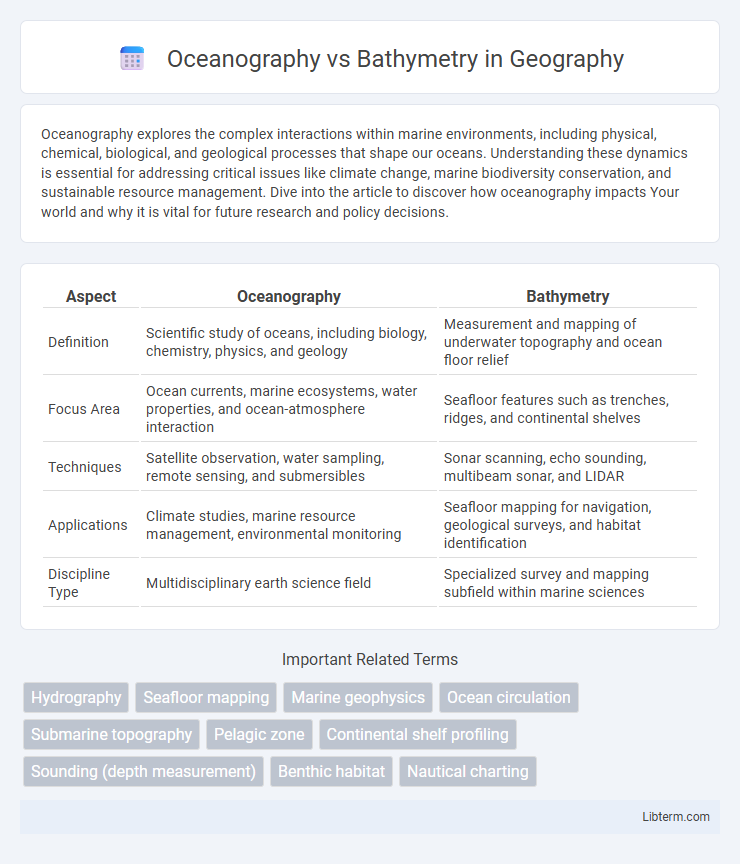
| Aspect | Oceanography | Bathymetry |
|---|---|---|
| Definition | Scientific study of oceans, including biology, chemistry, physics, and geology | Measurement and mapping of underwater topography and ocean floor relief |
| Focus Area | Ocean currents, marine ecosystems, water properties, and ocean-atmosphere interaction | Seafloor features such as trenches, ridges, and continental shelves |
| Techniques | Satellite observation, water sampling, remote sensing, and submersibles | Sonar scanning, echo sounding, multibeam sonar, and LIDAR |
| Applications | Climate studies, marine resource management, environmental monitoring | Seafloor mapping for navigation, geological surveys, and habitat identification |
| Discipline Type | Multidisciplinary earth science field | Specialized survey and mapping subfield within marine sciences |
Introduction to Oceanography and Bathymetry
Oceanography studies the physical, chemical, biological, and geological aspects of the ocean, providing a comprehensive understanding of marine environments. Bathymetry specifically maps the underwater topography, revealing the depth and shape of the ocean floor through techniques such as sonar and satellite altimetry. Integrating bathymetric data into oceanographic research enhances the analysis of marine habitats, ocean currents, and tectonic activity.
Defining Oceanography: Scope and Branches
Oceanography is the comprehensive study of the physical, chemical, biological, and geological aspects of the ocean, encompassing disciplines like marine biology, chemical oceanography, and physical oceanography. It investigates ocean currents, marine ecosystems, and the composition of seawater to understand the functions and interactions within marine environments. Bathymetry, a specialized branch of oceanography, focuses specifically on mapping the seafloor's topography, measuring underwater depths, and characterizing the ocean basin's shape and features.
What Is Bathymetry? Key Concepts Explained
Bathymetry is the scientific study of underwater depth of lake or ocean floors, focusing on measuring and mapping the topography beneath the water's surface. It involves using sonar, satellite data, and other remote sensing technologies to create detailed maps of underwater features such as trenches, seamounts, and continental shelves. Bathymetry provides essential data for oceanography, supporting navigation, marine biology research, and understanding geological processes beneath oceans.
Historical Development of Oceanography
The historical development of oceanography encompasses the systematic study of ocean currents, marine ecosystems, and seafloor geology, expanding significantly since the 19th century with the Challenger Expedition (1872-1876), which laid the groundwork for modern oceanographic science. Bathymetry, a crucial subset of oceanography, evolved through the use of lead lines and later echo sounding technologies, enabling accurate mapping of ocean depths and underwater topography. These advancements in bathymetric techniques have been instrumental in enhancing our understanding of ocean basins and plate tectonics, contributing to the comprehensive field of oceanography.
Bathymetric Techniques and Tools
Bathymetry involves the measurement of underwater topography using various advanced techniques such as multibeam echo sounders, side-scan sonar, and satellite altimetry, which provide high-resolution maps of the seafloor. These tools utilize sound waves to penetrate water layers and return depth data, enabling precise imaging of underwater features including trenches, seamounts, and continental shelves. Innovations in autonomous underwater vehicles (AUVs) and remotely operated vehicles (ROVs) have further enhanced bathymetric data collection by allowing access to challenging and deep oceanic terrains with improved accuracy.
How Oceanography and Bathymetry Intersect
Oceanography and bathymetry intersect through the study of underwater topography, where bathymetric data provides critical insights into ocean floor features such as trenches, ridges, and seamounts. Oceanographers use bathymetric maps to analyze ocean currents, marine habitats, and geological processes, enhancing understanding of marine ecosystems and tectonic activity. Integrating bathymetry into oceanographic research supports accurate modeling of ocean circulation and aids in navigation, resource exploration, and environmental monitoring.
Applications of Oceanography in Modern Science
Oceanography encompasses the study of ocean currents, marine ecosystems, and chemical properties of seawater, providing critical data for climate change research and weather prediction models. Bathymetry, a subset of oceanography, specifically maps the seafloor topography using sonar and satellite technology, aiding in navigation, underwater construction, and habitat mapping. Modern scientific applications of oceanography include monitoring carbon cycles, supporting fisheries management, and advancing marine conservation efforts through detailed analysis of oceanic processes.
Bathymetry’s Role in Underwater Mapping
Bathymetry is the scientific study of underwater depth and topography, playing a critical role in underwater mapping by providing detailed charts of seabed elevations and contours. It utilizes sonar, satellite altimetry, and remote sensing technologies to accurately measure ocean floor features, aiding in navigation, marine construction, and environmental monitoring. In contrast, oceanography encompasses a broader study of ocean processes, including physical, chemical, and biological aspects, while bathymetry specifically focuses on the underwater terrain.
Challenges in Oceanographic and Bathymetric Research
Oceanographic and bathymetric research face challenges including data collection in extreme marine environments, limited accessibility of deep-sea regions, and the high costs of deploying advanced technology such as autonomous underwater vehicles and sonar mapping systems. Variability in ocean currents, temperature, and salinity complicates the accuracy of oceanographic measurements, while complex seafloor topography and sediment types pose difficulties in bathymetric mapping. Integration of large datasets from diverse sources also requires sophisticated computational models and substantial processing power to ensure precise analysis and interpretation.
Future Trends in Oceanography and Bathymetry
Advancements in autonomous underwater vehicles (AUVs) and satellite remote sensing are revolutionizing oceanography and bathymetry by enabling high-resolution, real-time mapping of the seafloor and oceanic processes. Integration of artificial intelligence and machine learning algorithms enhances data analysis, improving predictive models for climate change impacts and marine ecosystem dynamics. Collaborative global initiatives like the Seabed 2030 project aim to achieve comprehensive, high-resolution bathymetric mapping of the entire ocean floor by 2030, driving innovation and scientific discovery.
Oceanography Infographic