Transform boundaries occur where tectonic plates slide past each other horizontally, leading to earthquakes and complex geological features. These boundaries are characterized by fault lines, such as the San Andreas Fault, which significantly influence seismic activity and landscape formation. Explore the rest of the article to understand how transform boundaries shape Earth's dynamic crust and impact your environment.
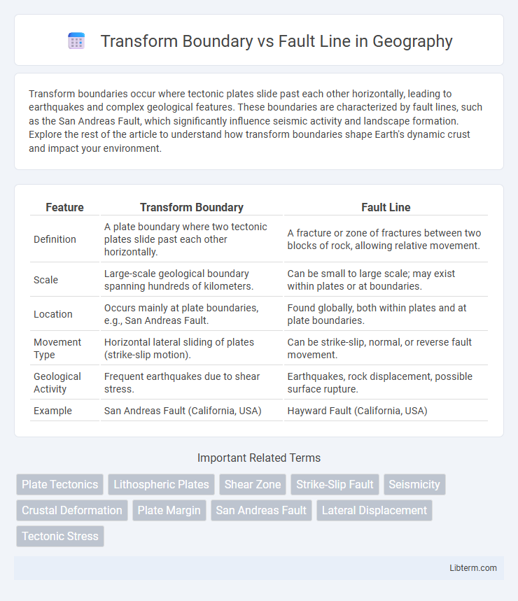
Table of Comparison
| Feature | Transform Boundary | Fault Line |
|---|---|---|
| Definition | A plate boundary where two tectonic plates slide past each other horizontally. | A fracture or zone of fractures between two blocks of rock, allowing relative movement. |
| Scale | Large-scale geological boundary spanning hundreds of kilometers. | Can be small to large scale; may exist within plates or at boundaries. |
| Location | Occurs mainly at plate boundaries, e.g., San Andreas Fault. | Found globally, both within plates and at plate boundaries. |
| Movement Type | Horizontal lateral sliding of plates (strike-slip motion). | Can be strike-slip, normal, or reverse fault movement. |
| Geological Activity | Frequent earthquakes due to shear stress. | Earthquakes, rock displacement, possible surface rupture. |
| Example | San Andreas Fault (California, USA) | Hayward Fault (California, USA) |
Introduction to Plate Tectonics
Transform boundaries occur where two tectonic plates slide past each other horizontally, creating significant seismic activity along their edges. Fault lines, such as the San Andreas Fault, are visible expressions of these plate boundaries where stress accumulation leads to earthquakes. Understanding the dynamics of transform boundaries is crucial for deciphering the complex behavior of Earth's lithosphere and the movement of plates in plate tectonics.
Defining Transform Boundaries
Transform boundaries are tectonic plate margins where plates slide horizontally past one another, characterized by strike-slip fault motion. These boundaries accommodate lateral displacement and are marked by distinct fault lines such as the San Andreas Fault in California. Transform boundaries play a critical role in shaping earthquake activity by releasing accumulated stress along their fault planes.
Understanding Fault Lines
Fault lines are fractures in the Earth's crust where blocks of rock have slipped past each other, often causing earthquakes along transform boundaries. Transform boundaries occur where two tectonic plates slide horizontally, and the fault lines here are characterized by lateral motion without significant vertical displacement. Understanding fault lines in transform boundaries is crucial for assessing seismic hazards and predicting earthquake behavior in regions like the San Andreas Fault in California.
Key Differences: Transform Boundary vs Fault Line
Transform boundaries are large-scale tectonic plate boundaries where two plates slide horizontally past each other, generating significant seismic activity and shaping extensive geological features. Fault lines, such as the San Andreas Fault, are fractures within Earth's crust where localized displacement occurs and can be part of a transform boundary or other fault systems. The key difference lies in scale and context: transform boundaries define plate interactions on a global scale, while fault lines are specific localized fractures that may or may not be associated with plate boundary movements.
Types of Transform Faults
Transform boundaries feature three main types of transform faults: oceanic, continental, and ridge-transform faults, each characterized by their location and interaction between tectonic plates. Oceanic transform faults occur between segments of mid-ocean ridges, accommodating lateral displacement of oceanic crust, while continental transform faults cut through continental crust, causing significant earthquakes. Ridge-transform faults link offset segments of mid-ocean ridges, facilitating the divergent movement of plates and maintaining seafloor spreading processes.
Major Examples Around the World
The San Andreas Fault in California exemplifies a transform boundary where the Pacific and North American plates slide past each other, causing frequent earthquakes. The North Anatolian Fault in Turkey represents another major transform boundary known for its seismic activity impacting densely populated areas. Unlike typical fault lines, which can occur in various tectonic settings, transform boundaries specifically involve horizontal plate motion, making them distinct in global geotectonic processes.
Geological Processes and Movement
Transform boundaries occur where two tectonic plates slide horizontally past each other, generating significant shear stress and causing earthquakes along the boundary. Fault lines, especially strike-slip faults, are localized fractures within the Earth's crust where these lateral movements concentrate and accumulate strain energy. The geological processes at transform boundaries drive seismic activity through brittle deformation and fault slip, distinguishing them from other plate boundary types such as convergent or divergent margins.
Earthquake Activity and Hazard Zones
Transform boundaries are tectonic plate margins where plates slide horizontally past each other, generating significant earthquake activity along fault lines due to the build-up and release of shear stress. Fault lines at transform boundaries, such as the San Andreas Fault in California, frequently produce shallow, intense earthquakes that pose high seismic hazard risks in adjacent populated zones. Mapping these fault lines and monitoring seismic activity are critical for earthquake hazard assessment and for developing mitigation strategies in vulnerable regions.
Scientific Methods for Studying Boundaries and Faults
Seismology employs seismic wave analysis to map transform boundaries and fault lines, revealing subsurface structures and displacement patterns. GPS geodesy measures precise ground movements at transform faults, quantifying slip rates and strain accumulation critical for earthquake forecasting. Geological field studies analyze rock formations and fault gouge to understand fault mechanics and boundary evolution over geological timescales.
Importance in Earth Sciences and Risk Assessment
Transform boundaries represent regions where tectonic plates slide past one another, generating significant seismic activity essential for understanding plate dynamics in Earth sciences. Fault lines, often associated with these boundaries, serve as critical indicators for assessing earthquake hazards, aiding in risk assessment and disaster preparedness. Accurate mapping and monitoring of transform boundaries and fault lines provide valuable data for predicting potential seismic events, ultimately enhancing public safety and infrastructure resilience.
Transform Boundary Infographic