The water table level determines the depth at which soil and rock are saturated with groundwater, directly impacting well drilling, agriculture, and construction projects. Fluctuations in the water table can signify changes in rainfall, usage, or environmental conditions, influencing how you manage water resources effectively. Explore the rest of this article to understand how water table levels affect your local ecosystem and water management strategies.
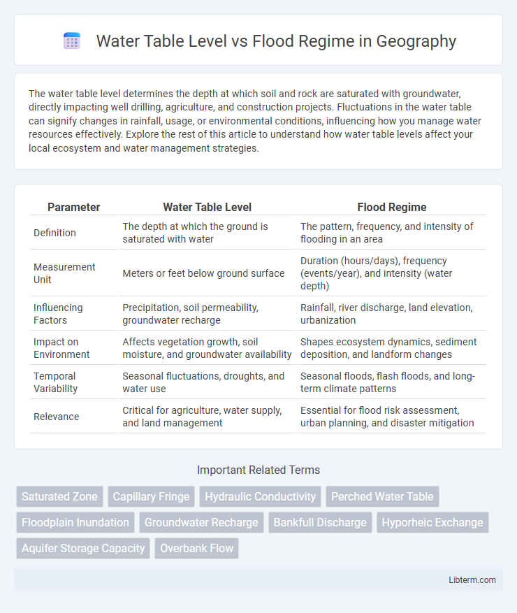
Table of Comparison
| Parameter | Water Table Level | Flood Regime |
|---|---|---|
| Definition | The depth at which the ground is saturated with water | The pattern, frequency, and intensity of flooding in an area |
| Measurement Unit | Meters or feet below ground surface | Duration (hours/days), frequency (events/year), and intensity (water depth) |
| Influencing Factors | Precipitation, soil permeability, groundwater recharge | Rainfall, river discharge, land elevation, urbanization |
| Impact on Environment | Affects vegetation growth, soil moisture, and groundwater availability | Shapes ecosystem dynamics, sediment deposition, and landform changes |
| Temporal Variability | Seasonal fluctuations, droughts, and water use | Seasonal floods, flash floods, and long-term climate patterns |
| Relevance | Critical for agriculture, water supply, and land management | Essential for flood risk assessment, urban planning, and disaster mitigation |
Understanding Water Table Levels
Water table levels, which indicate the depth at which soil and rock are saturated with water, directly influence flood regimes by determining the ground's capacity to absorb rainfall. High water tables reduce soil infiltration rates, increasing surface runoff and enhancing flood risk during heavy precipitation events. Monitoring water table fluctuations through piezometers and remote sensing tools is essential for predicting flood occurrences and managing watershed resilience.
Defining Flood Regime and Its Dynamics
Flood regime refers to the pattern, frequency, duration, and magnitude of flooding events in a particular area, critically influencing the water table level. Variations in the flood regime directly affect groundwater recharge and surface water interactions, leading to fluctuating water table depths over time. Understanding these dynamics is essential for managing ecosystems, agriculture, and urban planning in flood-prone regions.
Key Factors Influencing Water Table Levels
Soil permeability, precipitation patterns, and topography are key factors influencing water table levels in flood-prone areas. Seasonal rainfall intensity and duration affect groundwater recharge rates, while riverine and tidal flood regimes alter saturation zones, impacting water table fluctuations. Human activities such as land use changes, drainage systems, and groundwater extraction significantly modify natural water table dynamics, increasing flood risks.
How Flood Regime Impacts Groundwater
Flood regime significantly influences groundwater by altering the water table level through periodic inundation and recharge cycles. High-intensity floods raise the water table, enhancing groundwater recharge and increasing subsurface water availability, which benefits ecosystems and agricultural productivity. Conversely, prolonged dry periods in flood regimes can lower the water table, reducing groundwater storage and leading to potential water scarcity in affected regions.
Interconnection Between Water Table and Flood Events
The water table level significantly influences flood regimes by controlling groundwater storage and surface water interactions during flood events. Elevated water tables reduce soil infiltration capacity, increasing surface runoff and flood risk in flood-prone areas. Understanding the dynamic interplay between water table fluctuations and flood frequency is crucial for effective flood management and watershed planning.
Seasonal Variations in Water Table and Flood Patterns
Seasonal variations in water table levels significantly influence flood regimes by dictating groundwater recharge and surface runoff patterns. During wet seasons, elevated water tables raise flood risk through reduced soil infiltration and increased saturation, while dry seasons lower water tables, limiting flood occurrences due to enhanced absorption. Understanding these seasonal dynamics is crucial for accurate flood prediction and effective water resource management.
Human Activities Affecting Both Water Table and Flood Regime
Human activities such as urbanization, deforestation, and extensive groundwater extraction significantly alter the water table level and disrupt natural flood regimes, leading to increased flood risks and lowered water tables. Infrastructure development often reduces infiltration and increases surface runoff, which exacerbates flooding frequency and severity. Agricultural practices, including irrigation and drainage, further modify groundwater recharge rates and surface water flow patterns, impacting both water table dynamics and flood behavior.
Environmental Consequences of Changing Water Table Levels
Fluctuations in water table levels significantly influence flood regimes by altering soil saturation and groundwater flow, which impacts wetland ecosystems and biodiversity. Lowered water tables can lead to soil subsidence, reduced vegetation health, and increased vulnerability to drought, while elevated water tables may cause prolonged flooding, nutrient leaching, and habitat loss. These environmental consequences disrupt hydrological balance, reduce carbon sequestration, and threaten aquatic and terrestrial species survival.
Strategies for Managing Water Table and Flood Risk
Effective strategies for managing water table levels and flood risk include implementing controlled drainage systems to regulate groundwater, enhancing natural floodplains to absorb excess water, and constructing retention basins to mitigate flood peaks. Integrating real-time monitoring with predictive hydrological models enables optimal water table management and proactive flood response. Sustainable land use planning and restoration of wetlands further stabilize water tables and reduce flood frequency and severity.
Future Trends in Water Table and Flood Regime Research
Future trends in water table and flood regime research emphasize the integration of advanced remote sensing technologies and hydrological modeling to predict changes in groundwater levels and flood frequencies under varying climate scenarios. Emerging studies focus on the interaction between rising water tables and increased flood events, driven by extreme weather patterns and urbanization. Enhanced understanding of these dynamics supports more effective flood risk management and groundwater sustainability strategies in vulnerable regions.
Water Table Level Infographic