GIS and geostatistics integrate spatial data analysis with statistical techniques to uncover patterns and relationships within geographic information. This powerful combination enables improved decision-making in fields such as environmental management, urban planning, and natural resource exploration. Discover how these tools can enhance your spatial data projects by exploring the full article.
Table of Comparison
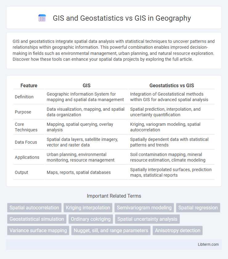
| Feature | GIS | Geostatistics vs GIS |
|---|---|---|
| Definition | Geographic Information System for mapping and spatial data management | Integration of Geostatistical methods within GIS for advanced spatial analysis |
| Purpose | Data visualization, mapping, and spatial data organization | Spatial prediction, interpolation, and uncertainty quantification |
| Core Techniques | Mapping, spatial querying, overlay analysis | Kriging, variogram modeling, spatial autocorrelation |
| Data Focus | Spatial data layers, satellite imagery, vector and raster data | Spatially dependent data with statistical patterns and trends |
| Applications | Urban planning, environmental monitoring, resource management | Soil contamination mapping, mineral resource estimation, climate modeling |
| Output | Maps, reports, spatial databases | Spatially interpolated surfaces, prediction maps, statistical reports |
Introduction to GIS: Core Concepts and Applications
Geographic Information Systems (GIS) integrate spatial data management, analysis, and visualization to support decision-making across various fields, emphasizing mapping and geographic relationships. Geostatistics enhances GIS by applying statistical methods to model spatial variability and uncertainty, improving predictions and spatial interpolation accuracy. Core GIS concepts involve data layers, spatial analysis tools, and geoprocessing techniques essential for land use planning, natural resource management, and environmental monitoring.
Understanding Geostatistics: Definitions and Importance
Geostatistics is a branch of statistics focusing on spatial or spatiotemporal datasets, crucial for analyzing and interpreting geographic information systems (GIS) data with spatial dependencies. It employs techniques like kriging and variogram modeling to predict and map continuous phenomena, enhancing the accuracy of spatial predictions in environmental science, mining, and agriculture. Unlike traditional GIS that primarily manages and visualizes spatial data, geostatistics provides robust statistical tools for modeling spatial variability and uncertainty.
Integrating Geostatistics within GIS: Synergies and Workflow
Integrating geostatistics within GIS enhances spatial data analysis by enabling more accurate modeling of spatial variability through techniques like kriging and spatial interpolation. This synergy allows for seamless data visualization, improved predictive mapping, and robust decision-making in environmental management, urban planning, and natural resource assessment. Incorporating geostatistical workflows into GIS platforms streamlines the handling of spatial autocorrelation and uncertainty, optimizing spatial prediction and resource allocation.
Key Differences: GIS Alone vs. GIS with Geostatistics
GIS alone primarily focuses on capturing, storing, analyzing, and visualizing spatial data through mapping techniques and geographic information processing. Incorporating geostatistics into GIS enhances spatial analysis by applying statistical models such as kriging, variogram analysis, and spatial autocorrelation to quantify spatial patterns, predict values at unsampled locations, and assess spatial uncertainty. The integration of geostatistics with GIS improves precision in environmental modeling, resource estimation, and risk assessment by providing robust spatial interpolation and better handling of spatial heterogeneity.
Data Input: Spatial Data vs. Geostatistical Data Sources
GIS primarily relies on spatial data inputs such as satellite imagery, aerial photography, and GPS coordinates to create and analyze geographic maps. Geostatistics, integrated within GIS frameworks, emphasizes geostatistical data sources including variograms, spatial correlation structures, and point-sampled data used for modeling spatial variability and uncertainty. The distinction in data input shapes the analytical capabilities, with GIS focusing on spatial visualization and geostatistics enhancing predictive spatial analysis and interpolation accuracy.
Analysis Techniques: Mapping vs. Spatial Prediction and Uncertainty
GIS primarily focuses on mapping and visualizing spatial data through layering and spatial queries, enabling efficient geographic analysis and decision-making. Geostatistics enhances GIS by incorporating spatial prediction techniques such as kriging, which estimates values at unsampled locations while quantifying uncertainty through variance or confidence intervals. Combining GIS with geostatistical methods improves accuracy in spatial modeling and supports better risk assessment by accounting for data uncertainty.
Real-World Applications: Comparative Case Studies
GIS integrates spatial data management and visualization to support urban planning and environmental monitoring, enhancing decision-making accuracy. Geostatistics applies advanced statistical techniques such as kriging and spatial autocorrelation to analyze and predict spatial phenomena, improving resource estimation in mining and agriculture. Comparative case studies reveal GIS excels in mapping and spatial analysis workflows, while geostatistics provides robust modeling of spatial variability crucial for risk assessment and natural hazard prediction.
Advantages and Limitations: GIS vs. GIS Enhanced by Geostatistics
GIS enhanced by geostatistics improves spatial data analysis through advanced interpolation methods like kriging, offering more accurate predictions of spatial phenomena compared to standard GIS. Advantages include enhanced handling of spatial uncertainty and improved modeling of spatial dependence, allowing for better decision-making in environmental monitoring and resource management. Limitations involve increased computational complexity and the need for specialized statistical expertise, which can restrict accessibility for general GIS users.
Tools and Software: From Standard GIS Platforms to Geostatistical Extensions
Standard GIS platforms like ArcGIS and QGIS provide robust spatial analysis and mapping capabilities, supporting data visualization, spatial querying, and basic statistical tools. Geostatistical extensions such as ArcGIS Geostatistical Analyst and SAGA GIS enhance these platforms by incorporating advanced statistical techniques like kriging, variogram modeling, and spatial interpolation for more precise spatial predictions. Integrating geostatistical tools with GIS software expands functionality, enabling users to perform sophisticated spatial data analyses crucial for environmental monitoring, resource management, and urban planning.
Future Trends: The Evolving Role of Geostatistics in GIS
Geostatistics is poised to transform GIS by enhancing spatial data analysis with advanced probabilistic models and machine learning techniques, enabling more accurate predictions and risk assessments. Integration of real-time data streams and high-resolution spatial datasets will drive the development of dynamic, adaptive GIS applications across environmental monitoring and urban planning. The evolving role of geostatistics will support smarter decision-making through improved spatial interpolation, uncertainty quantification, and predictive modeling capabilities within GIS platforms.
GIS and Geostatistics Infographic