Estuaries serve as vital transition zones where freshwater from rivers meets and mixes with saltwater from the ocean, creating unique and highly productive ecosystems rich in biodiversity. These dynamic environments offer crucial habitats for numerous species, support fisheries, protect shorelines from erosion, and enhance water quality by filtering pollutants. Discover how estuaries impact your environment and why preserving them is essential by continuing to explore this article.
Table of Comparison
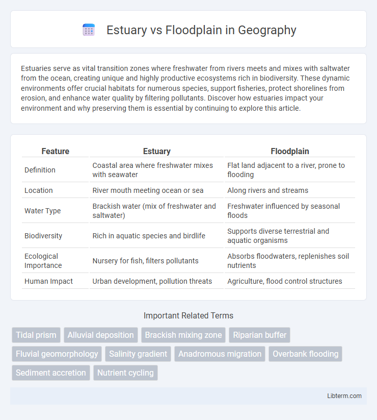
| Feature | Estuary | Floodplain |
|---|---|---|
| Definition | Coastal area where freshwater mixes with seawater | Flat land adjacent to a river, prone to flooding |
| Location | River mouth meeting ocean or sea | Along rivers and streams |
| Water Type | Brackish water (mix of freshwater and saltwater) | Freshwater influenced by seasonal floods |
| Biodiversity | Rich in aquatic species and birdlife | Supports diverse terrestrial and aquatic organisms |
| Ecological Importance | Nursery for fish, filters pollutants | Absorbs floodwaters, replenishes soil nutrients |
| Human Impact | Urban development, pollution threats | Agriculture, flood control structures |
Introduction to Estuaries and Floodplains
Estuaries are dynamic coastal environments where freshwater from rivers meets and mixes with saltwater from the ocean, creating nutrient-rich habitats that support diverse ecosystems. Floodplains are flat, low-lying areas adjacent to rivers that periodically flood, depositing sediments and fostering fertile soil crucial for agriculture and natural vegetation. Both estuaries and floodplains play essential roles in water filtration, wildlife habitat, and buffering against floods and storms.
Definition and Key Characteristics
An estuary is a coastal water body where freshwater from rivers meets and mixes with saltwater from the ocean, characterized by brackish water, tidal influences, and diverse ecosystems such as salt marshes and mangroves. A floodplain is a flat or gently sloping land adjacent to a river, prone to periodic flooding, with nutrient-rich soils that support fertile agricultural activities and riparian habitats. While estuaries function as critical transition zones between land and sea, floodplains primarily serve as natural flood control areas and sediment deposition sites along river corridors.
Formation Processes
Estuaries form through the mixing of freshwater from rivers with saltwater from the ocean, typically created by rising sea levels flooding river valleys, known as drowned river valleys or rias. Floodplains develop by sediment deposition during periodic river flooding, where overbank flow spreads sediments laterally, building flat, fertile land adjacent to river channels. The primary formation process of estuaries involves marine transgression and tidal action, while floodplains result from terrestrial sediment transport and fluvial dynamics.
Geographic Distribution
Estuaries are commonly found along coastlines where freshwater rivers meet the ocean, such as the Chesapeake Bay in the United States or the Thames Estuary in the United Kingdom. Floodplains primarily occur adjacent to inland rivers and streams, especially in regions with seasonal flooding like the Mississippi River Basin or the Amazon River floodplain. The geographic distribution of estuaries is strongly influenced by tidal patterns and sea level changes, while floodplains are shaped by river hydrology and sediment deposition over vast terrestrial expanses.
Ecological Importance
Estuaries serve as critical transition zones between river environments and maritime ecosystems, supporting high biodiversity by providing nutrient-rich waters that sustain diverse fish, bird, and invertebrate populations. Floodplains act as natural water storage areas during high river flows, reducing flood peaks and enhancing groundwater recharge while creating habitats for wetland species and promoting nutrient cycling. Both ecosystems play essential roles in maintaining water quality, supporting species migrations, and buffering climate change impacts through carbon sequestration and habitat connectivity.
Biodiversity and Wildlife
Estuaries support high biodiversity by providing nutrient-rich waters that serve as critical nurseries for various fish, birds, and invertebrates. Floodplains offer expansive habitats crucial for terrestrial wildlife, including migratory birds, amphibians, and mammals, facilitating breeding and foraging activities. Both ecosystems play essential roles in sustaining diverse species, with estuaries connected to marine life cycles and floodplains supporting freshwater and terrestrial organisms.
Human Activities and Impacts
Human activities in estuaries, such as industrial development, port construction, and urbanization, often lead to pollution and habitat degradation, disrupting vital breeding grounds for marine species. Floodplain modifications through agriculture, dam construction, and land reclamation alter natural flooding regimes, reducing nutrient-rich sediment deposits and impacting biodiversity. Both environments face challenges from increased sedimentation, water contamination, and loss of wetlands that undermine ecosystem services and coastal protection.
Role in Flood Management
Estuaries act as natural buffers by absorbing excess water from rivers and tides, reducing flood risks in coastal regions. Floodplains provide critical overflow areas during heavy rainfall, dispersing floodwaters and minimizing downstream flooding impacts. Both systems play complementary roles in flood management by enhancing water retention and mitigating flood peak volumes.
Environmental Threats
Estuaries face environmental threats such as pollution from agricultural runoff and industrial waste, which degrade water quality and disrupt aquatic ecosystems. Floodplains are vulnerable to habitat loss and river channelization, leading to reduced biodiversity and increased flood risks. Both ecosystems suffer from climate change impacts like sea-level rise and altered hydrological cycles, exacerbating their ecological fragility.
Conservation and Sustainable Management
Estuaries serve as critical buffers filtering pollutants and supporting diverse habitats, making their conservation vital for maintaining water quality and biodiversity. Floodplains contribute to natural flood mitigation by absorbing excess water, which aids in preventing downstream erosion and sustaining wetland ecosystems. Sustainable management of these areas involves restoring native vegetation, controlling development, and implementing policies that balance human activity with ecological integrity to enhance resilience against climate change impacts.
Estuary Infographic