Glaciation is the process of extensive ice formation and expansion, shaping vast landscapes through erosion and deposition. It significantly influences sea levels, climate patterns, and habitats over geological timescales. Discover how understanding glaciation reveals insights about Earth's past and its future by reading the rest of this article.
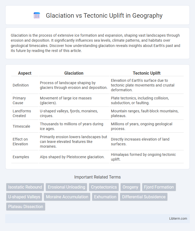
Table of Comparison
| Aspect | Glaciation | Tectonic Uplift |
|---|---|---|
| Definition | Process of landscape shaping by glaciers through erosion and deposition. | Elevation of Earth's surface due to tectonic plate movements and crustal deformation. |
| Primary Cause | Movement of large ice masses (glaciers). | Plate tectonics, including collision, subduction, or faulting. |
| Landforms Created | U-shaped valleys, fjords, moraines, cirques. | Mountain ranges, fault-block mountains, plateaus. |
| Timescale | Thousands to millions of years during ice ages. | Millions of years, ongoing geological process. |
| Effect on Elevation | Primarily erosion lowers landscapes but can leave elevated features like moraines. | Directly increases elevation of land surfaces. |
| Examples | Alps shaped by Pleistocene glaciation. | Himalayas formed by ongoing tectonic uplift. |
Introduction to Glaciation and Tectonic Uplift
Glaciation involves the growth and movement of massive ice sheets that reshape Earth's surface through erosion, deposition, and carving of valleys, significantly impacting landscapes. Tectonic uplift is a geological process where Earth's crust is elevated due to plate tectonic forces, forming mountain ranges and altering topography. Both glaciation and tectonic uplift are critical drivers of geomorphological change, influencing climate patterns and biodiversity distribution over geological time.
Defining Glaciation: Processes and Effects
Glaciation refers to the process of ice sheet and glacier formation that sculpts landscapes through erosion, transportation, and deposition of sediments. This process results in distinctive landforms such as U-shaped valleys, moraines, and fjords caused by the movement and melting of ice masses. Glaciation significantly impacts global sea levels and climate patterns by altering the Earth's surface and redistributing freshwater resources.
Understanding Tectonic Uplift: Mechanisms and Impact
Tectonic uplift occurs through the movement of Earth's lithospheric plates, primarily driven by processes such as subduction, continental collision, and mantle convection, which cause vertical elevation of landforms over geological time scales. This uplift influences landscape evolution by creating mountain ranges, altering drainage patterns, and affecting erosion rates. Understanding tectonic uplift mechanisms provides insight into orogenic processes and their role in shaping Earth's topography and regional climate variations.
Geological Features Formed by Glaciation
Glaciation sculpts distinctive geological features such as U-shaped valleys, fjords, and moraines, formed by the erosion and deposition of ice over millennia. Glacial activity also creates drumlins and eskers, which are streamlined hills and ridges composed of till and sediment deposited by retreating glaciers. These landforms contrast with the rugged mountain ranges and fault lines produced by tectonic uplift, highlighting the dramatic reshaping of Earth's surface by ice dynamics.
Landforms Resulting from Tectonic Uplift
Tectonic uplift results in distinct landforms such as mountain ranges, plateaus, and fault-block mountains formed by the vertical elevation of Earth's crust due to plate convergence, rifting, or mantle plume activity. These landforms often feature steep slopes, high elevations, and extensive fault lines, differing significantly from glacially carved landscapes. The ongoing tectonic forces can create complex topography, including folded strata, sharp ridges, and deep valleys, directly shaping regional geomorphology.
Comparing Erosion and Deposition Patterns
Glaciation produces distinctive erosion patterns such as U-shaped valleys, striations, and roche moutonnees, formed by the abrasive action of moving ice, contrasting with the more varied erosion from tectonic uplift, which typically generates rugged mountain ridges and sharp fault lines. Deposition from glaciation results in moraines, drumlins, and outwash plains composed of unsorted sediments, whereas tectonic uplift influences sediment distribution through river systems that deposit well-sorted alluvial fans and deltas. The spatial distribution and sediment characteristics offer key insights into distinguishing the geomorphological impacts of these two geological processes.
Climate Influence on Glaciation and Uplift
Glaciation patterns are strongly influenced by climate variables such as temperature and precipitation, where colder temperatures and increased snowfall promote glacier growth and advance. Tectonic uplift affects local climate by elevating landmasses, which leads to cooler temperatures and enhanced orographic precipitation, further facilitating glaciation development. The interplay between tectonic uplift and climate creates feedback mechanisms that regulate glacier dynamics and landscape evolution over geological timescales.
Case Studies: Regions Shaped by Glaciation vs Uplift
The European Alps exhibit significant landscape transformation primarily through glaciation, with deep U-shaped valleys and fjords carved by Pleistocene ice sheets, while the Himalayas demonstrate prominent tectonic uplift, featuring rapid elevation gain and intense seismic activity due to the ongoing collision of the Indian and Eurasian plates. Scandinavia presents classic glacial landforms such as drumlins and eskers formed during the last Ice Age, contrasting with the Rocky Mountains where tectonic uplift has created rugged peaks and extensive fault systems. These regions exemplify how glaciation sculpts terrain through ice erosion and deposition, whereas tectonic uplift reshapes landscapes through crustal deformation and mountain-building processes.
Human Impacts and Implications for Both Processes
Glaciation leads to significant alterations in landscapes through erosion and deposition, affecting water resources and agriculture by reshaping river valleys and soil distribution, often causing challenges for human settlements and infrastructure. Tectonic uplift elevates landforms, creating mountain ranges that influence climate patterns, biodiversity, and natural hazards such as earthquakes and landslides, which pose risks to communities and disrupt economies. Both processes drive long-term environmental changes that require adaptation in land use planning, disaster risk management, and conservation strategies to mitigate human impacts.
Conclusion: Interplay Between Glaciation and Tectonic Uplift
Glaciation and tectonic uplift together shape mountainous landscapes through dynamic interactions where glaciers carve valleys while uplift raises terrain. The balance between erosion from glaciation and elevation gain from tectonic activity controls topographic evolution and influences sediment cycles. Understanding this interplay is crucial for predicting long-term geomorphological changes and assessing regional climate impacts on mountain systems.
Glaciation Infographic