Geodesy precisely measures Earth's shape, gravitational field, and spatial orientation, playing a critical role in mapping and navigation technologies. Accurate geodetic data supports various applications, from land surveying to satellite positioning systems that enhance your everyday GPS accuracy. Explore the rest of the article to discover how geodesy impacts modern science and technology.
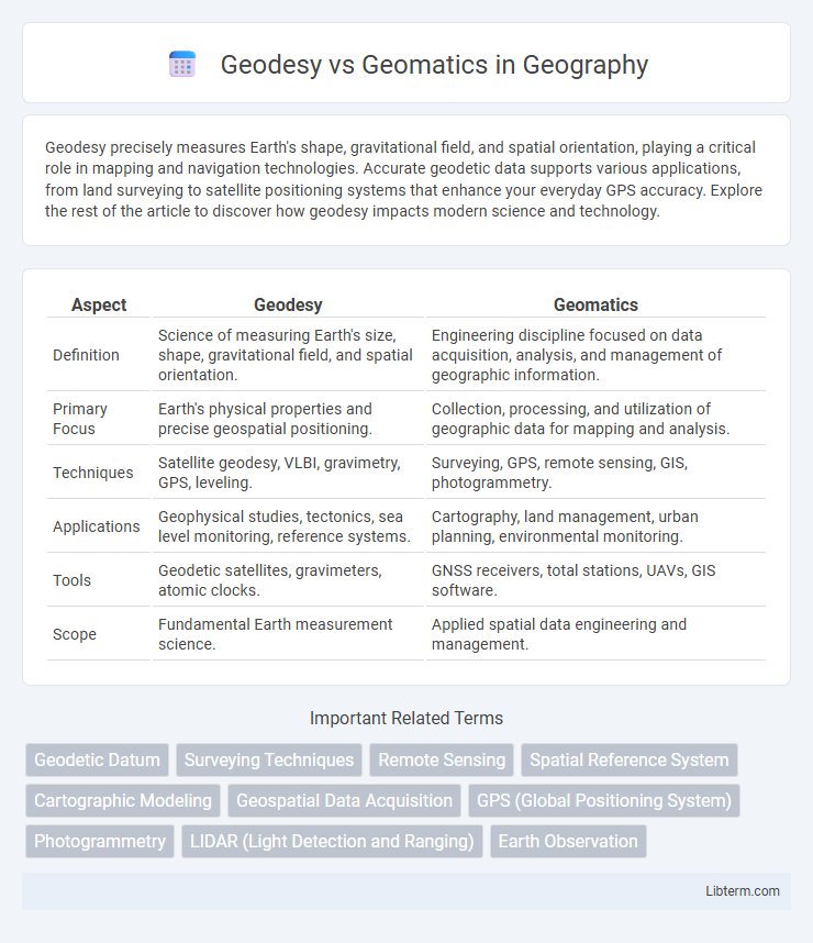
Table of Comparison
| Aspect | Geodesy | Geomatics |
|---|---|---|
| Definition | Science of measuring Earth's size, shape, gravitational field, and spatial orientation. | Engineering discipline focused on data acquisition, analysis, and management of geographic information. |
| Primary Focus | Earth's physical properties and precise geospatial positioning. | Collection, processing, and utilization of geographic data for mapping and analysis. |
| Techniques | Satellite geodesy, VLBI, gravimetry, GPS, leveling. | Surveying, GPS, remote sensing, GIS, photogrammetry. |
| Applications | Geophysical studies, tectonics, sea level monitoring, reference systems. | Cartography, land management, urban planning, environmental monitoring. |
| Tools | Geodetic satellites, gravimeters, atomic clocks. | GNSS receivers, total stations, UAVs, GIS software. |
| Scope | Fundamental Earth measurement science. | Applied spatial data engineering and management. |
Introduction to Geodesy and Geomatics
Geodesy is the scientific discipline that focuses on measuring and understanding Earth's geometric shape, gravitational field, and spatial orientation in three-dimensional space. Geomatics encompasses a broader scope, integrating geodesy with geospatial information technologies such as surveying, mapping, remote sensing, and geographic information systems (GIS) to capture, analyze, and manage spatial data. The relationship between geodesy and geomatics lies in geodesy providing the fundamental reference frameworks and precise measurements essential for accurate geospatial data collection and analysis in geomatics applications.
Defining Geodesy: Scope and Applications
Geodesy is the scientific discipline that measures and monitors the Earth's geometric shape, gravitational field, and spatial orientation, essential for precise mapping and navigation. Its scope includes determining geodetic coordinates, Earth's tides, and crustal deformation, supporting applications in satellite positioning, land surveying, and global climate studies. The integration of geodetic data enables accurate geospatial models critical for infrastructure development, disaster management, and space science.
Understanding Geomatics: Key Concepts
Geomatics integrates geodesy, remote sensing, GIS, and surveying to collect, analyze, and manage spatial data for environmental and infrastructural applications. It employs advanced technologies such as GNSS, LiDAR, and UAVs to enhance accuracy and efficiency in mapping and spatial analysis. Understanding geomatics involves mastering data acquisition, spatial data processing, and geospatial information system modeling to support decision-making in urban planning and resource management.
Historical Evolution of Geodesy and Geomatics
Geodesy originated from ancient practices of measuring Earth's shape and gravitational field, evolving through advancements in astronomy and satellite technology during the 20th century. Geomatics emerged as an interdisciplinary extension of geodesy in the late 20th century, integrating geographic information systems (GIS), remote sensing, and surveying technology. This evolution reflects a shift from traditional Earth measurement methods toward comprehensive spatial data acquisition and analysis for modern applications.
Core Methodologies in Geodesy
Geodesy's core methodologies revolve around precise measurement techniques such as satellite geodesy, triangulation, and leveling to determine Earth's shape, gravity field, and spatial coordinates. These techniques employ global navigation satellite systems (GNSS), gravimeters, and laser scanning to provide foundational data for mapping and navigation. In contrast, geomatics integrates these geodetic measurements with information technology and spatial data analysis for broader applications in geographic information systems (GIS) and remote sensing.
Fundamental Tools Used in Geomatics
Geomatics integrates advanced technologies such as GPS, remote sensing, and Geographic Information Systems (GIS) to collect, analyze, and manage spatial data. Unlike traditional geodesy, which primarily relies on precise measurements of the Earth's shape and gravity through instruments like total stations and gravimeters, geomatics leverages digital mapping and photogrammetry for versatile applications. The core tools in geomatics emphasize computational power and data integration, enabling efficient spatial analysis and decision-making across surveying, environmental monitoring, and urban planning.
Major Differences Between Geodesy and Geomatics
Geodesy primarily focuses on measuring and understanding Earth's geometric shape, gravitational field, and spatial orientation, while Geomatics integrates these principles with technology to collect, analyze, and manage geographic data. Geodesy involves precise calculations for global positioning and earth deformation studies, whereas Geomatics encompasses broader applications such as GIS, remote sensing, and surveying. The major difference lies in Geodesy's emphasis on Earth's physical properties and global reference systems, contrasted with Geomatics' emphasis on data acquisition, processing, and spatial information systems.
Overlapping Areas and Interdisciplinary Approaches
Geodesy and geomatics both contribute to earth measurement sciences, with overlapping areas including satellite positioning, geographic information systems (GIS), and remote sensing technologies. Interdisciplinary approaches integrate geodetic principles and geomatic techniques to improve spatial data accuracy, environmental monitoring, and land management applications. Advancements in global navigation satellite systems (GNSS) and spatial data infrastructures (SDI) exemplify the synergy between geodesy and geomatics, enhancing geospatial analysis and mapping precision.
Career Paths in Geodesy vs. Geomatics
Career paths in geodesy often lead to roles such as surveying engineer, geospatial data analyst, and satellite positioning specialist, focusing on precise Earth measurements and spatial data accuracy. Geomatics careers typically include opportunities as GIS analysts, remote sensing experts, and land information managers, emphasizing data integration and geographic information systems technology. Both fields require strong skills in mathematics, programming, and spatial analysis, but geodesy leans towards physical Earth measurement, while geomatics integrates broader data management and mapping technologies.
Future Trends and Innovations in Geospatial Sciences
Future trends in geodesy and geomatics emphasize integrating artificial intelligence and machine learning for enhanced data analysis and predictive modeling in geospatial sciences. Advanced satellite technologies, such as GNSS modernization and new earth observation sensors, drive improved accuracy and real-time spatial data acquisition. Innovations in unmanned aerial systems (UAS) and 3D mapping techniques contribute to more detailed environmental monitoring and infrastructure management.
Geodesy Infographic