Geographic Information Systems (GIS) enable the collection, analysis, and visualization of spatial data to improve decision-making across various industries. By integrating maps with data layers, GIS provides valuable insights into patterns, relationships, and trends that impact urban planning, environmental management, and logistics. Explore the rest of the article to discover how GIS can transform your approach to spatial data and drive smarter solutions.
Table of Comparison
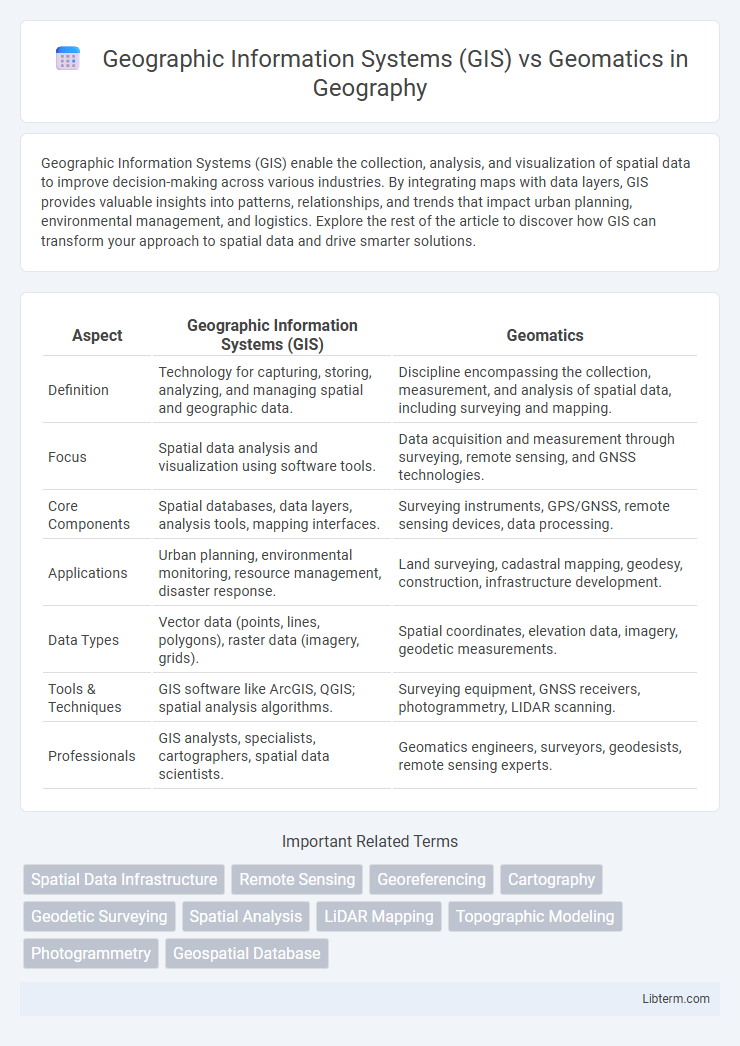
| Aspect | Geographic Information Systems (GIS) | Geomatics |
|---|---|---|
| Definition | Technology for capturing, storing, analyzing, and managing spatial and geographic data. | Discipline encompassing the collection, measurement, and analysis of spatial data, including surveying and mapping. |
| Focus | Spatial data analysis and visualization using software tools. | Data acquisition and measurement through surveying, remote sensing, and GNSS technologies. |
| Core Components | Spatial databases, data layers, analysis tools, mapping interfaces. | Surveying instruments, GPS/GNSS, remote sensing devices, data processing. |
| Applications | Urban planning, environmental monitoring, resource management, disaster response. | Land surveying, cadastral mapping, geodesy, construction, infrastructure development. |
| Data Types | Vector data (points, lines, polygons), raster data (imagery, grids). | Spatial coordinates, elevation data, imagery, geodetic measurements. |
| Tools & Techniques | GIS software like ArcGIS, QGIS; spatial analysis algorithms. | Surveying equipment, GNSS receivers, photogrammetry, LIDAR scanning. |
| Professionals | GIS analysts, specialists, cartographers, spatial data scientists. | Geomatics engineers, surveyors, geodesists, remote sensing experts. |
Introduction to GIS and Geomatics
Geographic Information Systems (GIS) involves the collection, analysis, and visualization of spatial data using software technologies to support decision-making across various fields. Geomatics encompasses a broader scope, integrating geospatial data acquisition, management, and interpretation through techniques like surveying, remote sensing, and cartography. Both GIS and Geomatics are critical for understanding spatial relationships but differ in their emphasis on data processing versus comprehensive geospatial data lifecycle management.
Defining Geographic Information Systems (GIS)
Geographic Information Systems (GIS) are specialized computer systems designed to capture, store, analyze, and visualize spatial and geographic data, enabling detailed mapping and spatial reasoning. Unlike the broader field of Geomatics, which encompasses all disciplines related to geographic data collection and management, GIS specifically focuses on the integration of hardware, software, and data for spatial analysis and decision-making. Key components of GIS include spatial databases, geospatial analysis tools, and user interfaces that support tasks such as urban planning, environmental monitoring, and resource management.
Understanding Geomatics: Scope and Applications
Geomatics encompasses the collection, analysis, and interpretation of data relating to the Earth's surface, integrating tools such as Geographic Information Systems (GIS), remote sensing, surveying, and cartography. Its broad scope extends beyond spatial data management to include applications in environmental monitoring, urban planning, agriculture, and natural resource management. By combining these technologies, geomatics provides comprehensive solutions for spatial data acquisition, analysis, and visualization across diverse industries.
Key Differences Between GIS and Geomatics
Geographic Information Systems (GIS) primarily focus on the collection, analysis, and visualization of spatial data to support decision-making processes. Geomatics encompasses a broader scope, including land surveying, geodesy, remote sensing, and cartography, integrating various technologies to acquire and manage geographic information. The key difference lies in GIS being a software-driven tool for spatial data handling, while Geomatics represents an interdisciplinary science involving both the technology and methods for measuring and interpreting the Earth's surface.
Core Components of Geomatics
Geomatics integrates Geographic Information Systems (GIS) as a core tool alongside global positioning systems (GPS), remote sensing, and surveying techniques to collect, analyze, and manage spatial data. The core components of geomatics emphasize data acquisition, spatial data analysis, geospatial data management, and visualization, enabling precise mapping and modeling of Earth's features. This multidisciplinary approach enhances decision-making in environmental monitoring, urban planning, and resource management through comprehensive geospatial information.
Core Components of GIS
Geographic Information Systems (GIS) consist of core components such as spatial data, hardware, software, people, and methods essential for capturing, storing, analyzing, and visualizing geospatial information. In contrast, Geomatics encompasses a broader scope including surveying, remote sensing, and mapping technologies, integrating these data acquisition techniques into GIS frameworks. The primary focus of GIS lies in data management and spatial analysis, leveraging components like geographic databases, GIS software tools, and geospatial analytical methods to support decision-making processes.
Educational Pathways: GIS vs Geomatics
Educational pathways in Geographic Information Systems (GIS) prioritize spatial data analysis, cartography, and computer science, often offered through specialized certifications, undergraduate, and graduate degrees in geography or environmental science. Geomatics education encompasses a broader spectrum, combining surveying, remote sensing, and geomatics engineering, typically available in engineering faculties with strong emphasis on technical skills like GPS technology and terrestrial surveying. Both disciplines require proficiency in GIS software, but Geomatics programs integrate physical measurement techniques, appealing to students seeking careers in land surveying, mapping, and geospatial infrastructure.
Career Opportunities in GIS and Geomatics
Career opportunities in Geographic Information Systems (GIS) focus on spatial data analysis, mapping, and geographic database management across industries like urban planning, environmental management, and transportation. Geomatics careers encompass broader roles involving land surveying, remote sensing, and geospatial technology development, supporting sectors such as construction, agriculture, and natural resource management. Both fields demand proficiency in geospatial software, data interpretation, and project management, with GIS offering specialized roles in spatial analytics and Geomatics providing diversified positions in data acquisition and geodetic sciences.
Real-World Applications: GIS and Geomatics Compared
Geographic Information Systems (GIS) primarily focus on capturing, analyzing, and visualizing spatial data for applications such as urban planning, environmental monitoring, and disaster management. Geomatics encompasses a broader range of techniques including surveying, remote sensing, and mapping, essential for land development, infrastructure design, and resource management. Both GIS and geomatics integrate spatial data but differ in scope, with GIS emphasizing data analysis and decision-making, while geomatics emphasizes data acquisition and precision measurement.
Future Trends in GIS and Geomatics
Emerging future trends in Geographic Information Systems (GIS) and Geomatics emphasize the integration of artificial intelligence (AI) and machine learning to enhance spatial data analysis and predictive modeling. Advances in real-time data acquisition through drones, satellite imagery, and IoT sensors are transforming geospatial data accuracy and temporal resolution. The convergence of GIS with augmented reality (AR) and virtual reality (VR) technologies is poised to revolutionize visualization and decision-making processes in urban planning, environmental monitoring, and disaster management.
Geographic Information Systems (GIS) Infographic