TPI (Topographic Position Index) measures the relative elevation of a specific location compared to its surrounding terrain, highlighting features like ridges, valleys, and slopes. This index is crucial for applications in geomorphology, hydrology, and landscape ecology by helping to identify landform patterns and terrain variability. Discover how TPI can enhance your understanding of topography and improve spatial analysis in the full article.
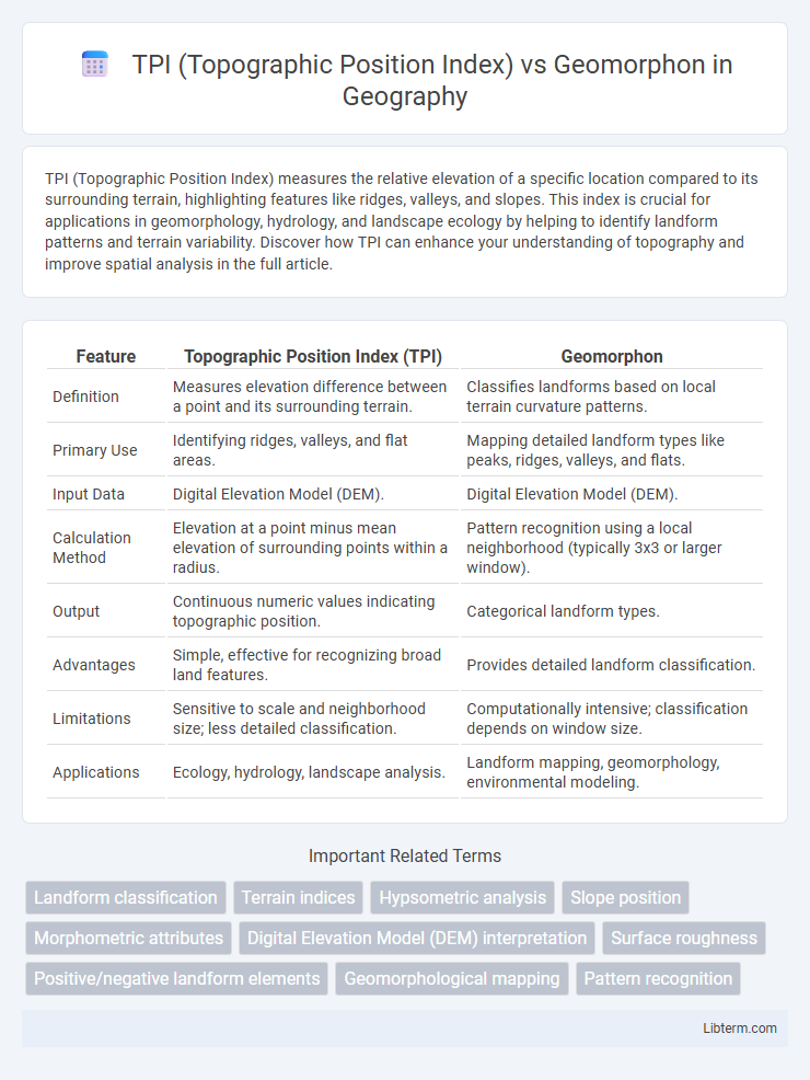
Table of Comparison
| Feature | Topographic Position Index (TPI) | Geomorphon |
|---|---|---|
| Definition | Measures elevation difference between a point and its surrounding terrain. | Classifies landforms based on local terrain curvature patterns. |
| Primary Use | Identifying ridges, valleys, and flat areas. | Mapping detailed landform types like peaks, ridges, valleys, and flats. |
| Input Data | Digital Elevation Model (DEM). | Digital Elevation Model (DEM). |
| Calculation Method | Elevation at a point minus mean elevation of surrounding points within a radius. | Pattern recognition using a local neighborhood (typically 3x3 or larger window). |
| Output | Continuous numeric values indicating topographic position. | Categorical landform types. |
| Advantages | Simple, effective for recognizing broad land features. | Provides detailed landform classification. |
| Limitations | Sensitive to scale and neighborhood size; less detailed classification. | Computationally intensive; classification depends on window size. |
| Applications | Ecology, hydrology, landscape analysis. | Landform mapping, geomorphology, environmental modeling. |
Introduction to TPI and Geomorphon
Topographic Position Index (TPI) quantifies the relative elevation of a point compared to its surrounding terrain, enabling the identification of ridges, valleys, and flat areas by calculating elevation differences within a specified neighborhood. Geomorphon classification interprets landforms by analyzing local terrain patterns based on slope and curvature, categorizing the landscape into distinct form elements such as peaks, ridges, shoulders, flats, foot slopes, and valleys. Both techniques provide critical insights for geomorphological mapping and landscape analysis, where TPI excels in elevation contrast detection and Geomorphon offers detailed form type recognition.
Defining Topographic Position Index (TPI)
Topographic Position Index (TPI) quantifies a location's elevation relative to the mean elevation of its surrounding area, highlighting landform types such as ridges, valleys, and flat surfaces. This metric is derived by calculating the difference between a central point's elevation and the average elevation within a defined neighborhood, enabling precise terrain classification. In contrast, Geomorphon identifies landform patterns using local slope, curvature, and shape, offering a categorical approach rather than a continuous index like TPI.
Understanding Geomorphon Classification
Geomorphon classification provides a detailed method to map landforms based on micro-topographic patterns derived from digital elevation models, capturing terrain features like ridges, valleys, and flat areas with distinct spatial signatures. Unlike TPI (Topographic Position Index), which quantifies relative elevation compared to surrounding terrain using a single-scale approach, geomorphons apply a multi-directional neighborhood analysis to detect local landform types more robustly and consistently. This classification enhances landscape analysis by incorporating geomorphological context, improving feature recognition in complex terrains for applications in geomorphology, ecology, and land management.
Key Principles Behind TPI Analysis
Topographic Position Index (TPI) analysis quantifies a location's elevation relative to its surrounding terrain by calculating the difference between a point's elevation and the mean elevation of neighboring cells, capturing landform features like ridges, valleys, and slopes. Key principles include scale-dependency, where the size of the neighborhood influences the detection of landform patterns, and elevation contrast, which highlights subtle topographic variations essential for ecological and geomorphological studies. In contrast, Geomorphon relies on pattern recognition of land surface forms using directional algorithms, emphasizing classification rather than continuous elevation differences.
How Geomorphon Mapping Works
Geomorphon mapping classifies landforms by analyzing the pattern of elevation relative to surrounding terrain using a fixed-size search window to identify characteristic shapes such as ridges, valleys, and flats. Unlike the Topographic Position Index (TPI), which measures elevation differences between a central pixel and its neighbors to quantify topographic position, geomorphon algorithms categorize terrain morphology by assessing local convexity and concavity patterns. This method provides detailed landform segmentation by capturing complex micro-topographies essential for geomorphological and ecological applications.
Applications of TPI in Terrain Analysis
TPI (Topographic Position Index) is widely applied in terrain analysis for identifying landform features such as ridges, valleys, and slopes by assessing elevation differences relative to the surrounding landscape. It is particularly useful in ecological studies for habitat mapping, erosion risk assessment, and hydrological modeling due to its ability to quantify micro-topographic variability. Compared to Geomorphon, which classifies landform types based on predefined patterns, TPI offers more continuous and scale-flexible terrain characterization essential for detailed geomorphological and environmental analyses.
Geomorphon Use Cases and Benefits
Geomorphon analysis provides detailed landform classification by identifying terrain features such as ridges, valleys, and flats based on local relief patterns, offering more comprehensive landscape representation than the Topographic Position Index (TPI). It is widely used in environmental mapping, hydrological modeling, and habitat suitability studies, enabling precise landform delineation critical for natural resource management and urban planning. The primary benefits of geomorphons include improved terrain characterization, enhanced pattern recognition in complex landscapes, and the ability to support multi-scale geomorphological assessments.
Comparison: TPI vs Geomorphon Accuracy
Topographic Position Index (TPI) measures relative elevation by comparing each cell's height to the average elevation of surrounding cells, providing precise distinction between ridges, valleys, and flat areas. Geomorphon classifies landforms into discrete types using pattern recognition over local terrain shapes, offering a more generalized but robust morphological categorization. TPI typically delivers higher accuracy in detecting subtle elevation variations, while Geomorphon excels in identifying broader geomorphological patterns with clearer landform delineations.
Limitations and Challenges of TPI and Geomorphon
TPI (Topographic Position Index) struggles with sensitivity to scale, often requiring multiple window sizes to accurately identify landforms, which complicates analysis and may introduce noise in heterogeneous terrains. Geomorphon classification encounters challenges in handling complex landscapes due to its reliance on predefined patterns, potentially oversimplifying diverse topographic features and reducing mapping precision. Both methods face difficulties in urban areas or anthropogenic landscapes where altered topography can distort natural landform signatures, limiting their effectiveness in such environments.
Choosing the Right Method for Your Geospatial Project
Choosing between Topographic Position Index (TPI) and Geomorphon methods depends on the specific objectives and scale of your geospatial project. TPI excels at quantifying relative elevation differences, making it ideal for identifying ridges, valleys, and flat areas in continuous terrain analysis. Geomorphon offers a more detailed morphological classification by analyzing local landform patterns, suitable for projects requiring precise landform categorization and terrain feature extraction.
TPI (Topographic Position Index) Infographic