GIS and Remote Sensing technologies revolutionize the way spatial data is collected, analyzed, and visualized for various applications like urban planning, environmental monitoring, and disaster management. By integrating geographic information systems with satellite or aerial imagery, you can gain deeper insights into land use changes, natural resource distribution, and climate patterns. Explore the rest of the article to understand how these tools can enhance your decision-making and operational efficiency.
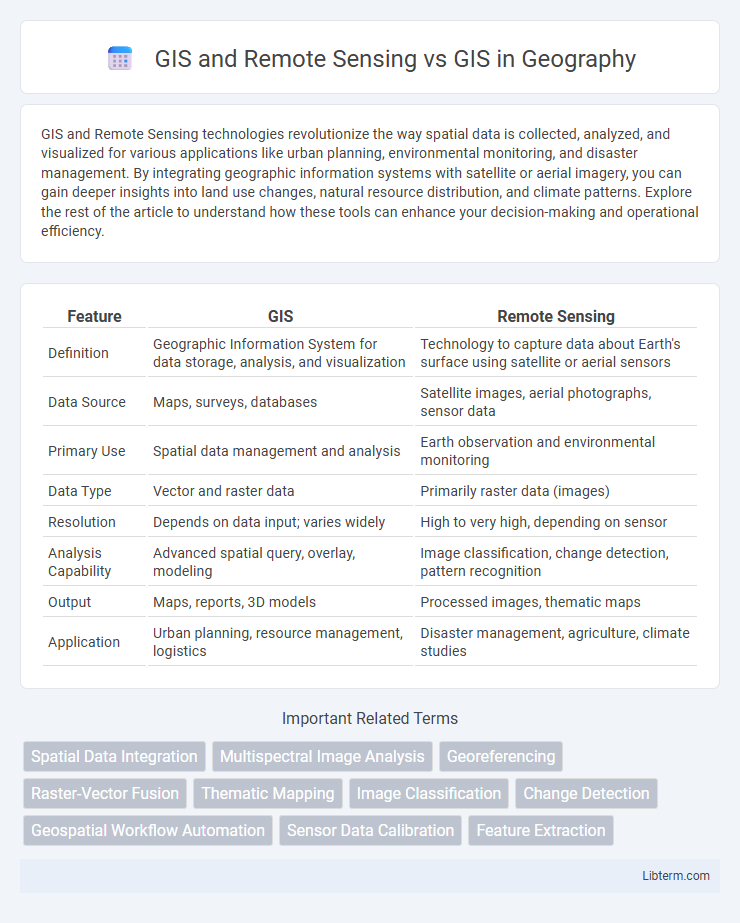
Table of Comparison
| Feature | GIS | Remote Sensing |
|---|---|---|
| Definition | Geographic Information System for data storage, analysis, and visualization | Technology to capture data about Earth's surface using satellite or aerial sensors |
| Data Source | Maps, surveys, databases | Satellite images, aerial photographs, sensor data |
| Primary Use | Spatial data management and analysis | Earth observation and environmental monitoring |
| Data Type | Vector and raster data | Primarily raster data (images) |
| Resolution | Depends on data input; varies widely | High to very high, depending on sensor |
| Analysis Capability | Advanced spatial query, overlay, modeling | Image classification, change detection, pattern recognition |
| Output | Maps, reports, 3D models | Processed images, thematic maps |
| Application | Urban planning, resource management, logistics | Disaster management, agriculture, climate studies |
Understanding GIS: Core Concepts and Applications
GIS integrates spatial data management, analysis, and visualization to support decision-making across diverse fields such as urban planning, environmental management, and transportation. Remote sensing, as a complementary technology, captures earth surface information through satellite or aerial imagery, enabling real-time monitoring and data collection that enhance GIS databases. Understanding GIS core concepts involves spatial data models, geoprocessing tools, and spatial analysis techniques essential for transforming raw geographic data into meaningful insights.
What is Remote Sensing? Principles and Role in Geospatial Analysis
Remote sensing involves the acquisition of information about Earth's surface without direct contact, using sensors mounted on satellites or aircraft to detect and measure reflected or emitted electromagnetic radiation. The principles of remote sensing include the interaction of electromagnetic waves with surface materials, sensor calibration, and data processing techniques to extract meaningful environmental information. In geospatial analysis, remote sensing plays a crucial role by providing up-to-date, large-scale spatial data that enhances GIS applications with accurate land use classification, change detection, and environmental monitoring.
GIS and Remote Sensing: How They Work Together
GIS and Remote Sensing integrate by combining spatial data analysis with real-time image acquisition, enabling enhanced environmental monitoring and urban planning. Remote Sensing captures detailed satellite or aerial imagery, which GIS processes to visualize, analyze, and interpret geographic patterns and changes over time. This synergy improves decision-making accuracy in disaster management, agriculture, and natural resource management.
Key Differences Between GIS and GIS with Remote Sensing
GIS (Geographic Information System) organizes, analyzes, and visualizes spatial data through maps and databases, enabling spatial decision-making and pattern recognition. GIS integrated with Remote Sensing incorporates satellite or aerial imagery to enhance data acquisition, providing real-time environmental monitoring and detailed surface analysis. The key difference lies in Remote Sensing's ability to supply raw spatial information from sensors, which GIS then processes and analyzes for various applications such as urban planning, agriculture, and disaster management.
Data Sources: GIS Alone vs GIS Enhanced by Remote Sensing
GIS alone primarily relies on data sourced from surveys, GPS, and existing spatial databases, offering detailed vector and attribute information for mapping and analysis. Integrating Remote Sensing enhances GIS with real-time, high-resolution satellite and aerial imagery, enabling detection of land cover changes, environmental monitoring, and accurate terrain analysis. The combination vastly improves spatial data accuracy and temporal resolution, facilitating dynamic decision-making in urban planning, agriculture, and disaster management.
Mapping Accuracy: Improvements Using Remote Sensing Data
GIS combined with remote sensing significantly enhances mapping accuracy by providing high-resolution satellite imagery and real-time data, enabling precise spatial analysis and feature extraction. Remote sensing data reduces positional errors inherent in traditional GIS by continuously updating geographic information with detailed multispectral and temporal datasets. Improved mapping accuracy through integration of remote sensing supports better decision-making in urban planning, environmental monitoring, and disaster management.
Applications: GIS Standalone vs GIS with Remote Sensing Capabilities
GIS standalone primarily supports spatial data analysis, mapping, and location-based decision-making across urban planning, environmental management, and logistics. Integrating Remote Sensing with GIS enhances applications by providing real-time, high-resolution satellite or aerial imagery, enabling precise monitoring of land use changes, disaster management, and agricultural health assessment. The combined system enables dynamic data updates and more accurate predictive modeling compared to GIS alone.
Workflow Integration: Combining Remote Sensing and GIS
Integrating Remote Sensing with Geographic Information Systems (GIS) enhances spatial data analysis by combining real-time satellite imagery with geospatial databases, enabling dynamic environmental monitoring and precise mapping. The workflow integration involves preprocessing remote sensing data, extracting key features, and importing these datasets into GIS platforms for advanced spatial modeling and decision-making. This combination optimizes resource management, disaster response, and urban planning through improved data accuracy and comprehensive spatial analysis.
Advantages and Limitations of Integrating Remote Sensing in GIS
Integrating Remote Sensing into GIS enhances spatial data accuracy and temporal monitoring capabilities by providing real-time satellite imagery and multispectral data, which support detailed environmental analysis and disaster management. Advantages include improved land use classification, efficient resource management, and the ability to detect changes over large and inaccessible areas, while limitations involve high data acquisition costs, the need for specialized processing skills, and potential resolution constraints depending on sensor types. This integration also faces challenges in data compatibility and the complexity of combining heterogeneous datasets, requiring advanced software and expertise to maximize its analytical potential.
Future Trends: Evolving Role of Remote Sensing in GIS
Future trends in GIS highlight the expanding role of remote sensing, driving advancements in spatial data acquisition and analysis. High-resolution satellite imagery and real-time data integration enhance geospatial modeling, supporting applications from urban planning to environmental monitoring. The convergence of machine learning and remote sensing within GIS platforms is set to revolutionize predictive analytics and decision-making processes.
GIS and Remote Sensing Infographic