GIS technology enables detailed spatial analysis and mapping, transforming raw data into actionable insights for various industries such as urban planning, environmental management, and logistics. It integrates geographic information with data visualization tools, enhancing decision-making accuracy and operational efficiency. Explore the rest of the article to discover how GIS can revolutionize Your workflow and strategic approach.
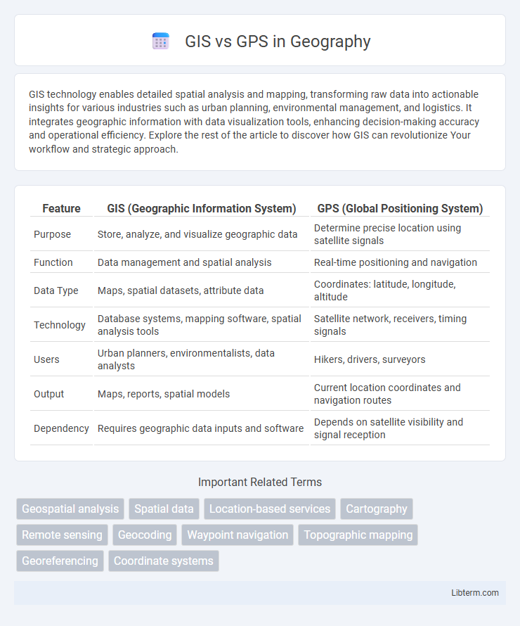
Table of Comparison
| Feature | GIS (Geographic Information System) | GPS (Global Positioning System) |
|---|---|---|
| Purpose | Store, analyze, and visualize geographic data | Determine precise location using satellite signals |
| Function | Data management and spatial analysis | Real-time positioning and navigation |
| Data Type | Maps, spatial datasets, attribute data | Coordinates: latitude, longitude, altitude |
| Technology | Database systems, mapping software, spatial analysis tools | Satellite network, receivers, timing signals |
| Users | Urban planners, environmentalists, data analysts | Hikers, drivers, surveyors |
| Output | Maps, reports, spatial models | Current location coordinates and navigation routes |
| Dependency | Requires geographic data inputs and software | Depends on satellite visibility and signal reception |
Understanding GIS and GPS: Definitions and Core Concepts
Geographic Information Systems (GIS) are computer-based tools that capture, analyze, and visualize spatial data to support decision-making and mapping, integrating various data layers such as terrain, demographics, and infrastructure. Global Positioning System (GPS) technology relies on satellite signals to provide precise location coordinates, enabling real-time navigation and tracking. While GPS supplies accurate positional data, GIS processes and interprets this data to create meaningful geographic insights and spatial analysis.
Key Differences Between GIS and GPS
Geographic Information Systems (GIS) store, analyze, and visualize spatial data to support decision-making across various fields, while Global Positioning Systems (GPS) provide precise location data using satellite signals for navigation and tracking. GIS integrates multiple layers of spatial information such as maps, demographics, and environmental data, enabling complex spatial analysis, whereas GPS primarily delivers real-time coordinates with latitude, longitude, and altitude. The key difference lies in GIS's analytical capabilities compared to GPS's role as a satellite-based positioning tool.
Main Applications of GIS in Various Industries
GIS technology plays a crucial role in urban planning by enabling detailed spatial analysis for infrastructure development and zoning regulations. In environmental management, GIS facilitates habitat conservation, natural resource monitoring, and disaster risk assessment through comprehensive geospatial data integration. The agriculture sector leverages GIS for precision farming techniques, optimizing crop yields by analyzing soil composition, weather patterns, and irrigation needs.
Primary Uses of GPS in Everyday Life
GPS technology primarily serves as a crucial tool for navigation and location tracking in everyday life, enabling users to find routes during travel, monitor fitness activities, and locate lost devices. Its integration in smartphones and vehicles allows seamless real-time mapping, traffic updates, and location-based services that enhance daily convenience and safety. Moreover, GPS supports emergency response systems by providing accurate positioning data to dispatch assistance efficiently.
How GIS and GPS Work Together
GIS integrates spatial data from various sources, while GPS provides precise location coordinates through satellite signals. Combining GPS data with GIS enables real-time mapping, analysis, and decision-making across industries such as transportation, agriculture, and urban planning. This synergy enhances accuracy in tracking, spatial visualization, and resource management.
Data Types and Sources in GIS vs GPS
GIS integrates diverse data types such as vector, raster, and attribute data sourced from satellite imagery, aerial photography, and ground surveys to analyze spatial relationships and patterns. GPS primarily provides real-time geospatial coordinates (latitude, longitude, altitude) collected via satellite signals for precise location tracking. While GIS emphasizes data variety and detailed contextual information, GPS focuses on precise positional data enabling navigation and mapping.
Technologies and Tools: GIS Software vs GPS Devices
GIS software integrates spatial data analysis, mapping, and visualization tools, enabling users to interpret complex geographic information through platforms like ArcGIS, QGIS, and MapInfo. GPS devices utilize satellite signals from the Global Positioning System to provide real-time location tracking and navigation, featuring handheld receivers, vehicle-mounted units, and mobile apps. While GIS focuses on data management and spatial analysis, GPS technology centers on precise positioning and navigation capabilities.
Accuracy and Limitations: GIS Compared to GPS
GIS offers high spatial analysis accuracy by integrating diverse geographic data layers, while GPS provides precise real-time location coordinates with typical accuracy ranging from 3 to 10 meters for civilian use. Limitations of GIS include dependency on the quality of input data and computational resources, whereas GPS accuracy can be affected by signal obstructions, atmospheric conditions, and multipath errors. Combining GIS with GPS enhances overall geospatial accuracy by leveraging GPS positioning with GIS's extensive spatial datasets and analytic tools.
Future Trends in GIS and GPS Integration
Future trends in GIS and GPS integration emphasize enhanced real-time data fusion through advanced AI algorithms and IoT connectivity, enabling more precise geospatial analytics and decision-making processes. The rise of 5G networks will significantly improve the speed and reliability of location-based services, facilitating seamless updates between GIS platforms and GPS devices. Emerging technologies like augmented reality (AR) and machine learning will further refine spatial data visualization and predictive modeling, driving innovations in smart city planning and autonomous navigation systems.
Choosing the Right Tool: When to Use GIS or GPS
Choose GPS for real-time location tracking, navigation, and precise positioning tasks in fieldwork or outdoor activities. Opt for GIS when analyzing spatial data, mapping complex relationships, and managing geospatial databases for planning and decision-making. Combining GIS and GPS enhances accuracy and depth in geographic information projects, leveraging GPS data collection within GIS platforms.
GIS Infographic