Delta represents change or difference in various fields such as mathematics, science, and finance, often symbolizing the rate of change or a difference in values. In geography, a delta is a landform at the mouth of a river where it spreads into multiple channels before entering a larger body of water, creating fertile and dynamic ecosystems. Explore the rest of the article to discover how delta impacts your surroundings and its significance across different disciplines.
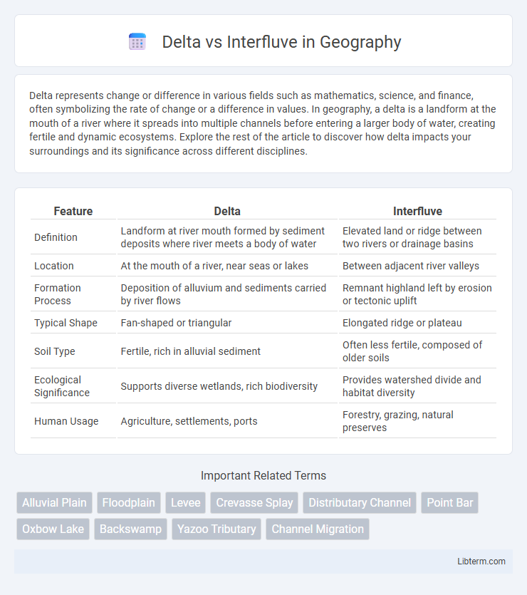
Table of Comparison
| Feature | Delta | Interfluve |
|---|---|---|
| Definition | Landform at river mouth formed by sediment deposits where river meets a body of water | Elevated land or ridge between two rivers or drainage basins |
| Location | At the mouth of a river, near seas or lakes | Between adjacent river valleys |
| Formation Process | Deposition of alluvium and sediments carried by river flows | Remnant highland left by erosion or tectonic uplift |
| Typical Shape | Fan-shaped or triangular | Elongated ridge or plateau |
| Soil Type | Fertile, rich in alluvial sediment | Often less fertile, composed of older soils |
| Ecological Significance | Supports diverse wetlands, rich biodiversity | Provides watershed divide and habitat diversity |
| Human Usage | Agriculture, settlements, ports | Forestry, grazing, natural preserves |
Introduction to Delta and Interfluve
Delta forms at river mouths where sediment deposits create landforms projecting into a water body, typically characterized by distributaries shaping a fan or triangular pattern. Interfluves are elevated land areas separating adjacent river valleys or drainage basins, composed mainly of resistant bedrock or sediments that influence watershed boundaries. Understanding the contrasting geomorphological features of deltas and interfluves is essential for studying fluvial processes and landscape evolution.
Definition of Delta
A delta is a landform formed at the mouth of a river where it deposits sediment as it flows into an ocean, sea, or lake, creating a triangular or fan-shaped area. This depositional feature typically consists of multiple distributaries and fertile soil that supports diverse ecosystems and agriculture. In contrast, an interfluve refers to the higher land or ridge between adjacent river valleys, characterized by erosion rather than sediment deposition.
Definition of Interfluve
Interfluve refers to the elevated land or ridge that separates two adjacent river valleys or drainage basins, serving as a natural boundary between distinct fluvial systems. Unlike a delta, which forms at a river's mouth through sediment deposition into a standing body of water, an interfluve is characterized by its position between converging streams rather than at their endpoints. This geomorphological feature influences watershed hydrology by directing surface runoff and sediment transport away from one basin toward another.
Formation Processes of Delta
Delta formation begins at the mouth of a river where sediment loads carried by the river stream deposit upon entering a slower-moving or stagnant body of water such as an ocean, sea, or lake. This sediment accumulation occurs due to a decrease in flow velocity, causing particles to settle and gradually build up landforms. Contrarily, interfluves are elevated regions between adjacent valleys or river channels, formed primarily by erosion and weathering rather than sediment deposition like in deltas.
Formation Processes of Interfluve
Interfluves form through processes of prolonged erosion and sediment deposition that isolate elevated land between adjacent river valleys, contrasting the sediment-rich, fan-shaped landforms of deltas created at river mouths. The formation of interfluves involves differential weathering and fluvial incision during periods of stable base levels, which preserve these upland ridges as remnants of ancient landscapes. These geomorphic features play a key role in drainage patterns and soil distribution, distinguishing them from deltaic environments shaped primarily by sediment accumulation and water dispersal dynamics.
Key Differences Between Delta and Interfluve
A delta is a landform created at the mouth of a river where sediment deposition occurs as the river meets a standing body of water, while an interfluve refers to the elevated land or ridge between two adjacent river valleys. Deltas are characterized by their triangular shape and fertile soil, supporting rich biodiversity and agriculture, whereas interfluves typically consist of higher ground with less sediment accumulation and are important for drainage patterns. The key differences lie in their formation processes, location within a drainage basin, and their ecological significance in fluvial landscapes.
Ecological Importance of Deltas and Interfluves
Deltas serve as critical ecological hotspots, supporting diverse aquatic and terrestrial species due to nutrient-rich sediments deposited by rivers, which promote high productivity and complex food webs. Interfluves, the elevated lands between river valleys, play a crucial role in maintaining regional biodiversity by providing unique habitats and acting as natural barriers that influence water flow and soil distribution. Both landforms contribute significantly to ecosystem services, including water filtration, flood mitigation, and carbon sequestration, essential for environmental stability and resilience.
Human Impact on Deltas vs Interfluves
Human activities drastically alter deltas through urbanization, agriculture, and resource extraction, leading to wetland loss, increased sediment deposition disruption, and heightened flood risks. In contrast, interfluves experience less direct impact from human development but face soil erosion and deforestation due to land-use changes and agriculture expansion. Effective management strategies in deltas and interfluves are essential to mitigate environmental degradation and preserve ecological functions.
Examples of Famous Deltas and Interfluves
The Mississippi River Delta in the United States and the Nile Delta in Egypt are two of the most iconic and expansive river deltas globally, characterized by their rich sediment deposits and biodiversity. In contrast, notable interfluves such as the Brazilian Plateau between the Amazon and Tocantins rivers and the Rhenish Massif in Germany showcase elevated lands separating adjacent river valleys, influencing regional hydrology and ecology. These examples highlight the distinct geomorphological features and ecological significance of deltas and interfluves in shaping landscapes and habitats.
Conclusion: Comparing Delta and Interfluve
Deltas form at river mouths where sediment deposits create landforms extending into bodies of water, while interfluves are elevated areas between adjacent river valleys shaped by erosion. The primary difference lies in their geomorphological processes: deltas accumulate sediments in aquatic environments, whereas interfluves are shaped by subaerial erosion and weathering. Understanding these distinctions is essential for river basin management and ecological conservation.
Delta Infographic