Regional climate shapes local weather patterns, influencing agriculture, biodiversity, and human activities. Understanding these variations helps communities adapt to changing environmental conditions more effectively. Explore the rest of this article to discover how regional climate impacts your daily life and long-term planning.
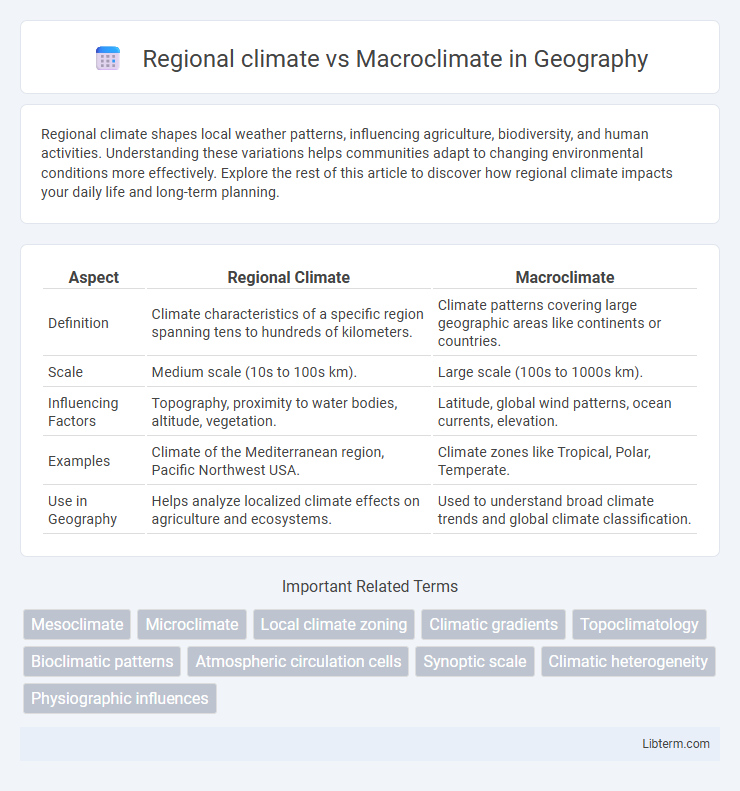
Table of Comparison
| Aspect | Regional Climate | Macroclimate |
|---|---|---|
| Definition | Climate characteristics of a specific region spanning tens to hundreds of kilometers. | Climate patterns covering large geographic areas like continents or countries. |
| Scale | Medium scale (10s to 100s km). | Large scale (100s to 1000s km). |
| Influencing Factors | Topography, proximity to water bodies, altitude, vegetation. | Latitude, global wind patterns, ocean currents, elevation. |
| Examples | Climate of the Mediterranean region, Pacific Northwest USA. | Climate zones like Tropical, Polar, Temperate. |
| Use in Geography | Helps analyze localized climate effects on agriculture and ecosystems. | Used to understand broad climate trends and global climate classification. |
Defining Regional Climate and Macroclimate
Regional climate refers to the typical weather patterns experienced in a specific geographic area over an extended period, influenced by factors such as topography, altitude, and proximity to bodies of water. Macroclimate encompasses the broad-scale climate characteristics that affect large regions or continents, driven primarily by global atmospheric circulation patterns and latitude. Understanding regional climate requires analyzing localized climate data within the context of the overarching macroclimate framework.
Key Differences Between Regional and Macroclimate
Regional climate refers to the climate patterns specific to a particular geographic area, influenced by local factors such as topography, vegetation, and proximity to water bodies. Macroclimate encompasses broader climate characteristics affecting large-scale regions or entire continents, driven primarily by global atmospheric circulation and latitude. Key differences include the scale of influence, with regional climate impacted more by localized conditions, while macroclimate represents overarching climatic trends spanning vast areas.
Geographic Scales: Regional vs Macroclimate
Regional climate refers to the climate characteristics observed within a specific geographic area, typically ranging from tens to hundreds of kilometers, influenced by local features such as topography, vegetation, and water bodies. Macroclimate encompasses broader climatic patterns over extensive geographic scales, often spanning thousands of kilometers or entire continents, driven by large-scale atmospheric circulation and global climate systems. Understanding the distinction between regional and macroclimate is essential for accurate climate modeling and environmental planning at different spatial resolutions.
Influencing Factors of Regional Climate
Regional climate is shaped by factors such as topography, altitude, proximity to water bodies, and prevailing wind patterns, which create localized weather conditions distinct from the broader macroclimate. Variations in vegetation cover and urbanization also influence temperature and precipitation levels within a region. These elements interact to produce unique climatic characteristics that differ from the general macroclimate of a larger geographic area.
Major Drivers of Macroclimate Patterns
Major drivers of macroclimate patterns include global atmospheric circulation, ocean currents, latitude, and altitude, which collectively influence temperature and precipitation on a large scale. Regional climate emerges when these macroclimate factors interact with local topography, vegetation, and water bodies, creating more specific environmental conditions. Understanding the distinction between macroclimate and regional climate is essential for predicting weather patterns and managing ecosystems effectively.
Examples of Regional Climate Zones
Regional climate refers to the climate patterns observed in a specific area within a broader macroclimate, which encompasses large-scale climatic conditions over extensive regions or continents. Examples of regional climate zones include the Mediterranean climate characterized by hot, dry summers and mild, wet winters found in parts of California and the Mediterranean Basin, the maritime climate with moderate temperatures and high humidity along coastal regions like the Pacific Northwest, and the continental climate with extreme temperature variations typical of the central United States. These regional zones demonstrate how local geographical features such as proximity to oceans, mountain ranges, and elevation influence distinct climate characteristics within the overarching macroclimate.
Case Studies: Macroclimate Across Continents
Macroclimate refers to large-scale climate patterns influencing extensive geographic regions, often encompassing entire continents, while regional climate describes localized variations within this broader context. Case studies across continents, such as the Sahara Desert's macroclimate affecting North Africa versus the microclimatic adaptations in the Mediterranean basin, highlight how macroclimate shapes ecological and human systems on a broad scale. Analysis of macroclimate phenomena like the Asian monsoon or North American jet streams reveals significant impacts on agriculture, biodiversity, and weather extremes across continental regions.
Regional Climate Change Impacts
Regional climate refers to the localized atmospheric conditions influenced by geographic features such as mountains, valleys, and bodies of water, distinguishing it from the broader macroclimate that covers extensive areas like continents or oceans. Regional climate change impacts include altered precipitation patterns, increased frequency of extreme weather events, and shifts in ecosystem dynamics, affecting agriculture, water resources, and biodiversity. Understanding these localized changes is essential for targeted adaptation and mitigation strategies to address climate vulnerability in specific regions.
The Role of Macroclimate in Global Weather Systems
Macroclimate encompasses large-scale atmospheric patterns influencing weather across continents and oceans, playing a crucial role in shaping global climate systems such as jet streams, trade winds, and ocean currents. This broad climatic framework determines temperature, precipitation, and pressure trends over extensive geographical areas, which in turn drive regional climate variations and local weather phenomena. Understanding macroclimate dynamics is essential for predicting long-term climate shifts, extreme weather events, and their impacts on ecosystems and human societies worldwide.
Integrating Regional and Macroclimate in Climate Research
Integrating regional climate and macroclimate in climate research enhances the accuracy of climate models by capturing localized variations within broader climatic patterns. Regional climate data, characterized by microclimates influenced by topography and land use, complements macroclimate information derived from global atmospheric circulation and oceanic trends. This combined approach supports more precise predictions of climate impacts on ecosystems, agriculture, and urban planning.
Regional climate Infographic