A map legend explains the symbols, colors, and icons used to represent various features on a map, ensuring accurate interpretation of geographical data. Understanding the legend allows you to quickly identify landmarks, terrain types, and other critical information essential for navigation or analysis. Explore the rest of the article to master map reading and enhance your spatial awareness.
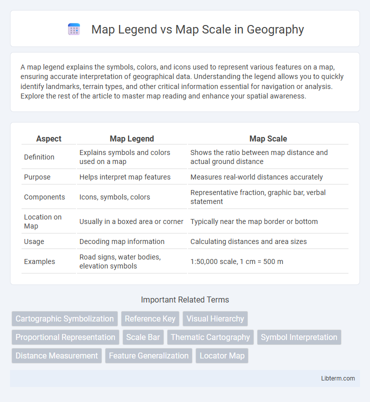
Table of Comparison
| Aspect | Map Legend | Map Scale |
|---|---|---|
| Definition | Explains symbols and colors used on a map | Shows the ratio between map distance and actual ground distance |
| Purpose | Helps interpret map features | Measures real-world distances accurately |
| Components | Icons, symbols, colors | Representative fraction, graphic bar, verbal statement |
| Location on Map | Usually in a boxed area or corner | Typically near the map border or bottom |
| Usage | Decoding map information | Calculating distances and area sizes |
| Examples | Road signs, water bodies, elevation symbols | 1:50,000 scale, 1 cm = 500 m |
Understanding Map Legends: Key to Interpreting Symbols
A map legend is essential for interpreting the symbols, colors, and patterns used on a map, enabling users to understand the represented features such as roads, rivers, and landmarks. Unlike a map scale, which provides a ratio for measuring real-world distances from the map, the legend explains the meaning behind the visual elements, ensuring accurate navigation and data analysis. Mastery of the map legend enhances the ability to read complex maps effectively, making it a fundamental tool in geography and cartography.
Decoding Map Scales: Measuring Real-world Distances
Map scales provide the crucial metric for translating distances on a map to their real-world equivalents, expressed as ratios such as 1:50,000, indicating one unit on the map equals 50,000 units on the ground. Decoding map scales involves understanding units of measurement, whether in miles, kilometers, or feet, to accurately estimate spatial relationships and travel distances. Unlike the map legend, which explains symbols and colors, the map scale directly influences navigation, planning, and geographical analysis by quantifying actual distances.
Map Legend vs Map Scale: Key Differences Explained
Map legend and map scale serve distinct purposes in cartography; the map legend explains symbols, colors, and patterns used on the map to represent various features, while the map scale indicates the ratio between distances on the map and actual ground distances. The legend provides context to interpret map symbols like roads, rivers, and boundaries, whereas the scale helps measure real-world distances using units such as kilometers or miles. Understanding the differences between map legend and map scale ensures accurate reading and navigation based on the map's visual and spatial information.
Importance of Map Legends in Navigation
Map legends are crucial for interpreting symbols, colors, and patterns on maps, enabling users to understand geographic information accurately. Unlike map scales that provide distance measurements, legends decode the meaning behind visual elements, facilitating precise navigation and decision-making. Effective use of map legends enhances spatial awareness and reduces errors in route planning and wayfinding.
How Map Scales Enhance Geographical Accuracy
Map scales provide a precise ratio between distances on a map and actual ground distances, significantly enhancing geographical accuracy by enabling users to measure real-world distances accurately. Unlike map legends, which explain symbols and colors, map scales quantify spatial relationships and facilitate detailed navigation and spatial analysis. Accurate map scales are essential for tasks such as land surveying, urban planning, and environmental studies, where exact geographical measurements are critical.
Visual Representation: Symbols vs. Ratios
Map legends use visual symbols to represent various features such as roads, rivers, and landmarks, providing an easy-to-understand guide for map interpretation. Map scales display ratios or graphical bars indicating the relationship between distances on the map and real-world measurements, allowing users to accurately gauge spatial dimensions. Symbols in legends enhance visual comprehension, while scales quantify distance, both essential for effective navigation and geographic analysis.
Common Types of Map Legends and Their Uses
Common types of map legends include symbols, colors, and line patterns that represent features such as roads, water bodies, elevation, and land use, essential for interpreting map data accurately. Color-coded legends provide quick visual cues for different terrain types or political boundaries, while symbol legends explain icons for points of interest like hospitals, airports, or parks. Understanding these legend types enhances map readability and enables users to extract precise geographic information for navigation or spatial analysis.
Types of Map Scales and Their Applications
Map scales include representative fraction (RF), verbal, and graphic scales, each serving specific functions in cartography. Representative fraction scales, such as 1:50,000, precisely indicate the ratio between map distance and real-world distance, ideal for detailed topographic maps. Verbal scales use descriptive terms like "one inch equals one mile," while graphic scales visually represent distance, aiding users in measuring map features directly and supporting applications from urban planning to hiking navigation.
Practical Examples: Using Legends and Scales Together
A map legend explains the symbols and colors used on a map, such as roads, parks, and elevation, while the map scale provides the ratio of a distance on the map to the actual ground distance, for example, 1 inch equals 1 mile. Practical examples include using a legend to identify a hiking trail marked by a dashed line and the scale to measure the trail's real length. Combining both elements helps users accurately interpret spatial information and plan routes effectively in navigation and urban planning.
Choosing the Right Map: Factors Based on Legend and Scale
Selecting the right map requires careful consideration of the map legend, which explains symbols and colors representing geographic features, and the map scale, indicating the ratio of map distance to real-world distance. A detailed legend ensures clarity in interpreting landmarks, boundaries, and terrain types, while an appropriate scale determines the map's level of detail and its suitability for navigation or planning. Balancing a comprehensive legend with a scale that matches the intended use--such as large-scale maps for urban planning or small-scale maps for regional overviews--optimizes map effectiveness.
Map Legend Infographic