A map sheet provides a detailed representation of a specific geographic area, displaying important features such as terrain, landmarks, and boundaries with precision. These sheets are essential for navigation, planning, and geographic analysis, offering valuable information for professionals and enthusiasts alike. Explore the rest of the article to discover how to effectively use map sheets for your projects and adventures.
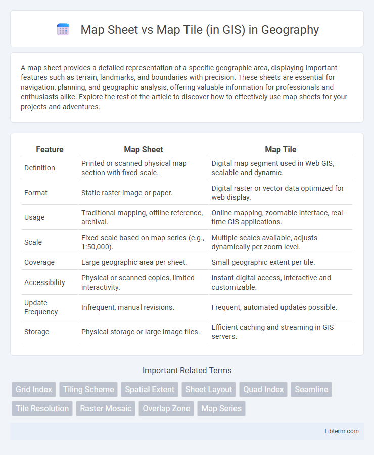
Table of Comparison
| Feature | Map Sheet | Map Tile |
|---|---|---|
| Definition | Printed or scanned physical map section with fixed scale. | Digital map segment used in Web GIS, scalable and dynamic. |
| Format | Static raster image or paper. | Digital raster or vector data optimized for web display. |
| Usage | Traditional mapping, offline reference, archival. | Online mapping, zoomable interface, real-time GIS applications. |
| Scale | Fixed scale based on map series (e.g., 1:50,000). | Multiple scales available, adjusts dynamically per zoom level. |
| Coverage | Large geographic area per sheet. | Small geographic extent per tile. |
| Accessibility | Physical or scanned copies, limited interactivity. | Instant digital access, interactive and customizable. |
| Update Frequency | Infrequent, manual revisions. | Frequent, automated updates possible. |
| Storage | Physical storage or large image files. | Efficient caching and streaming in GIS servers. |
Introduction to Map Sheets and Map Tiles in GIS
Map sheets in GIS refer to standardized paper or digital map segments divided according to a fixed grid system, often used for large-scale mapping and easy referencing. Map tiles represent smaller, dynamic sections of a map designed for efficient loading and display in web-based mapping services, optimized for zooming and panning. Both map sheets and map tiles are essential for organizing spatial data, but map sheets focus on traditional cartographic layouts while map tiles enhance interactive, real-time map visualization.
Defining Map Sheets: Concepts and Applications
Map sheets are predefined rectangular sections of geographic space, often based on standardized grid systems like the UTM or national mapping frameworks, used to organize and index spatial data for ease of reference and navigation. These map sheets represent static, fixed extents with consistent scale and coordinate boundaries, facilitating systematic map production, archival, and distribution in traditional cartography and GIS workflows. Applications of map sheets include facilitating land management, cadastral mapping, and topographic analysis by providing a coherent framework to segment and manage large-scale spatial datasets.
Understanding Map Tiles: Basics and Functions
Map tiles in GIS are small, square images that collectively display geospatial data at various zoom levels, allowing efficient, dynamic map rendering on web platforms. Each map tile represents a specific area with fixed coordinates and resolution, facilitating fast loading and seamless panning by loading only relevant tiles as users navigate. Unlike traditional map sheets, which are static and large-scale printed maps covering fixed extents, map tiles enable scalable, interactive mapping experiences essential for modern digital applications.
Key Differences Between Map Sheets and Map Tiles
Map sheets in GIS are fixed-format, large-scale paper maps representing a specific geographic area, designed for traditional cartographic use, whereas map tiles are digital, small rectangular images used to assemble interactive, zoomable maps on web platforms. Map sheets have set boundaries, scales, and are static, while map tiles dynamically load based on zoom level and user interaction, allowing seamless navigation across different geographic regions. The key differences lie in their format, scalability, and user experience: map sheets prioritize detailed, high-quality print representation, and map tiles optimize for flexible, efficient digital visualization.
Data Organization: Map Sheet vs Map Tile Structure
Map sheets in GIS represent traditional, fixed-area map units with consistent scales and predefined boundaries, often following standardized grid systems used for large-scale cartographic indexing. Map tiles utilize a dynamic, hierarchical structure organizing spatial data into a pyramid of zoom levels, enabling efficient web mapping through seamless loading and rendering of smaller, manageable image or vector segments. This hierarchical tiling approach optimizes data storage and retrieval by breaking maps into discrete, uniformly sized sections, contrasting with the static and larger extent of map sheets.
Scalability and Resolution: Which Suits Your GIS Needs?
Map sheets in GIS represent fixed, large-scale printed areas with set resolutions, ideal for detailed analysis and precise navigation but limited by physical size and scalability constraints. Map tiles, by contrast, are small, standardized, and seamlessly stitched digital segments that enhance scalability and dynamic resolution, enabling efficient zooming and faster loading across varying devices and platforms. Choosing between map sheets and map tiles depends on project requirements for resolution fidelity, scalability demands, and whether the GIS application prioritizes static, high-detail print maps or flexible, interactive digital mapping solutions.
Use Cases: When to Use Map Sheets or Tiles in GIS Projects
Map sheets are ideal for detailed, large-scale projects such as urban planning or environmental impact assessments where precise boundaries and annotations are necessary. Map tiles enhance web-based GIS applications by enabling fast, scalable map rendering and seamless zooming across various resolutions, ideal for real-time data visualization and interactive mapping. Selecting map sheets or tiles depends on project requirements for detail accuracy, data update frequency, and user interaction needs within the GIS platform.
Advantages and Limitations of Map Sheets
Map sheets offer standardized, large-scale representations of geographic areas that facilitate detailed analysis and easy reference for planners and researchers. Their fixed boundaries and consistent scale provide reliable context but limit flexibility in displaying dynamic, zoomable content compared to map tiles. Map sheets can be cumbersome to update and share digitally, often requiring physical storage or scanning, which reduces accessibility and integration with web-based GIS platforms.
Benefits and Drawbacks of Map Tiles
Map tiles in GIS provide efficient data loading by dividing maps into smaller, manageable square images that enhance performance and responsiveness, especially for web mapping applications. They enable scalable zoom levels and faster rendering but may lead to increased storage requirements and complexity in managing multiple tile sets. Unlike map sheets, tiles limit seamless printing options and can introduce visual discontinuities at tile boundaries.
Choosing the Right Approach: Map Sheet or Map Tile for Your GIS Workflow
Choosing between map sheets and map tiles depends on the scale, resolution, and update frequency required in your GIS workflow. Map sheets offer fixed, large-scale representations ideal for detailed analysis and printing, while map tiles provide dynamic, scalable, and web-friendly solutions optimized for fast loading and interactive user experiences. Selecting the right approach ensures efficient data management, seamless integration, and optimal performance tailored to specific project needs.
Map Sheet Infographic