Floodplains are low-lying areas adjacent to rivers or streams that experience periodic flooding, playing a crucial role in natural water management and ecosystem health. These regions absorb excess water during heavy rains, reducing flood risks downstream and providing habitats for diverse wildlife. Discover how understanding floodplain dynamics can protect Your property and enhance environmental stewardship by reading the full article.
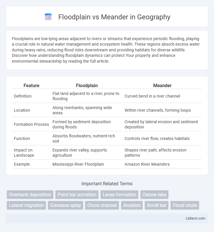
Table of Comparison
| Feature | Floodplain | Meander |
|---|---|---|
| Definition | Flat land adjacent to a river, prone to flooding | Curved bend in a river channel |
| Location | Along riverbanks, spanning wide areas | Within river channels, forming loops |
| Formation Process | Formed by sediment deposition during floods | Created by lateral erosion and sediment deposition |
| Function | Absorbs floodwaters, nutrient-rich soil | Controls river flow, creates habitats |
| Impact on Landscape | Expands river valley, supports agriculture | Shapes river path, affects erosion patterns |
| Example | Mississippi River Floodplain | Amazon River Meanders |
Understanding Floodplains: Definition and Formation
Floodplains are low-lying areas adjacent to rivers or streams formed primarily through sediment deposition during periodic flooding, creating fertile soil ideal for agriculture. Meanders are naturally curved bends in a river's course that contribute to floodplain development by eroding outer banks and depositing sediments on inner banks, gradually expanding the floodplain. Understanding the dynamic interaction between meander migration and sediment deposition is crucial for predicting floodplain evolution and managing flood risks effectively.
What Are Meanders? Key Characteristics
Meanders are natural, sinuous curves or bends in a river channel formed by the lateral erosion and deposition of sediment. Key characteristics include a well-developed point bar on the inner bank where sediment accumulates, and a cut bank on the outer bank where erosion occurs, creating a dynamic balance that shapes the river's path. Meanders typically develop in low-gradient floodplains and contribute to the river's ability to dissipate energy and transport sediment efficiently.
Geological Processes Shaping Floodplains
Floodplains form through the repetitive process of sediment deposition during river overflows, where fine particles settle as floodwaters recede, gradually creating flat, fertile land adjacent to the river channel. Meanders develop by lateral erosion and deposition along river bends, where the outer bank experiences erosion while sediment accumulates on the inner bank, contributing to the floodplain's dynamic landscape. These geological processes combine to shape floodplains by continuously redistributing sediments and altering channel patterns over time.
How Meanders Develop in River Systems
Meanders develop in river systems through the natural process of erosion and deposition, where water flow erodes the outer banks and deposits sediment on the inner banks, creating sinuous curves. The formation of meanders typically occurs in the middle to lower courses of rivers with gentle gradients and cohesive bank materials, leading to lateral channel migration. Over time, meanders can evolve into oxbow lakes as river channels cut off loops, highlighting dynamic fluvial processes distinct from the broader, flat floodplain areas adjacent to rivers.
Floodplain Ecosystems and Their Importance
Floodplains host diverse ecosystems characterized by nutrient-rich soils and seasonal flooding, supporting unique plant and animal species adapted to variable water levels. These ecosystems enhance water filtration, reduce flood impacts, and maintain biodiversity by providing critical habitat for fish, birds, and amphibians. Floodplain health is vital for sustaining ecosystem services that benefit agriculture, water quality, and climate resilience.
Meander Features: Oxbow Lakes and Point Bars
Meanders are characterized by their sinuous bends that create distinctive features such as oxbow lakes and point bars. Oxbow lakes form when a meander loop is cut off from the main river channel, resulting in a crescent-shaped water body isolated from flowing water. Point bars develop on the inner banks of meanders where sediment deposition occurs due to slower water velocity, contributing to the dynamic reshaping of the river's course.
Floodplain vs. Meander: Key Differences
Floodplains are broad, flat areas adjacent to rivers that experience periodic flooding and sediment deposition, while meanders are the winding curves or bends found within a river channel formed by lateral erosion and deposition. Floodplains support diverse ecosystems and act as natural buffers during high water events, whereas meanders influence river flow dynamics and channel shape. The key difference lies in their function and formation: floodplains result from floodwaters spreading over land, whereas meanders develop from the river's erosional and depositional processes within its channel.
The Role of Water Flow in Floodplain and Meander Formation
Water flow dynamics play a crucial role in the formation of floodplains and meanders by shaping the landscape through erosion and deposition processes. In floodplains, slow-moving water during overflows deposits sediments over a wide area, creating fertile, flat land. Meanders develop as flowing water erodes the outer banks and deposits sediment on the inner banks, causing the river to curve and change channels over time.
Human Impact on Floodplains and Meanders
Human activities such as urbanization, agriculture, and dam construction significantly alter floodplains by reducing their natural capacity to absorb floodwaters, leading to increased flood risks and habitat loss. Meanders are often modified through channelization and levee construction to control water flow, which disrupts sediment deposition, affects aquatic ecosystems, and diminishes biodiversity. These interventions compromise the natural functions of floodplains and meanders, exacerbating erosion, reducing groundwater recharge, and impacting water quality.
Floodplain and Meander Management: Conservation Strategies
Floodplain and meander management involves preserving natural water flow patterns and maintaining riparian vegetation to reduce erosion and improve habitat quality. Conservation strategies include implementing buffer zones, restoring wetlands, and preventing construction in floodplain areas to enhance flood absorption and promote biodiversity. Effective management supports river health by stabilizing meanders and safeguarding floodplain ecosystems from degradation.
Floodplain Infographic