Sediment transport plays a crucial role in shaping riverbeds, coastlines, and aquatic habitats by moving particles such as sand, gravel, and silt through water flow and wind. Understanding the mechanisms behind sediment transport helps in managing erosion, sedimentation, and the design of hydraulic structures. Explore the rest of the article to discover how sediment dynamics impact your environment and engineering projects.
Table of Comparison
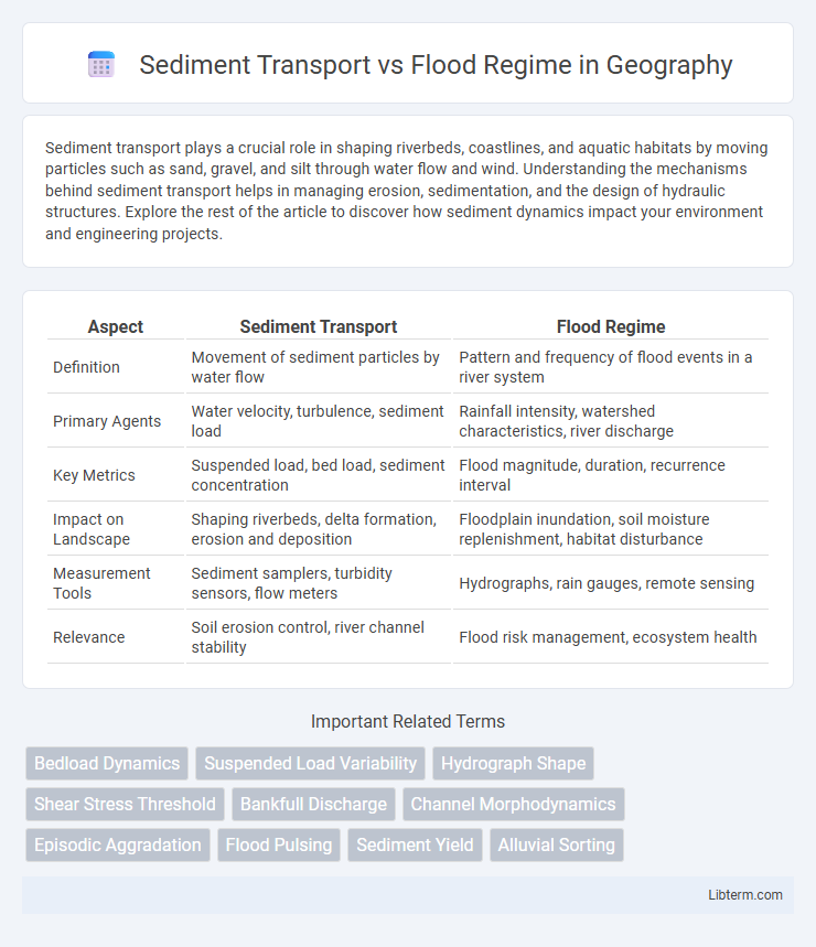
| Aspect | Sediment Transport | Flood Regime |
|---|---|---|
| Definition | Movement of sediment particles by water flow | Pattern and frequency of flood events in a river system |
| Primary Agents | Water velocity, turbulence, sediment load | Rainfall intensity, watershed characteristics, river discharge |
| Key Metrics | Suspended load, bed load, sediment concentration | Flood magnitude, duration, recurrence interval |
| Impact on Landscape | Shaping riverbeds, delta formation, erosion and deposition | Floodplain inundation, soil moisture replenishment, habitat disturbance |
| Measurement Tools | Sediment samplers, turbidity sensors, flow meters | Hydrographs, rain gauges, remote sensing |
| Relevance | Soil erosion control, river channel stability | Flood risk management, ecosystem health |
Introduction to Sediment Transport and Flood Regimes
Sediment transport involves the movement of sediment particles by water flow, influencing river morphology and aquatic habitats. Flood regimes characterize the frequency, magnitude, and duration of flood events, impacting sediment deposition and erosion patterns. Understanding the interaction between sediment transport and flood regimes is essential for effective water resource management and ecosystem preservation.
Defining Sediment Transport Processes
Sediment transport processes involve the movement of sediment particles by water flow within a river or floodplain, influenced by factors such as flow velocity, sediment size, and channel morphology. These processes include bedload transport, where sediments roll or slide along the riverbed, and suspended load transport, where finer particles are carried within the water column. Understanding sediment transport is essential for assessing flood regime impacts, erosion patterns, and sediment deposition zones in floodplains.
Understanding Flood Regimes
Flood regimes characterize the frequency, magnitude, duration, and seasonality of flood events, directly influencing sediment transport dynamics in river systems. Variations in flood regimes impact sediment erosion, deposition, and channel morphology, shaping ecosystem habitats and water quality. Understanding flood regimes is essential for predicting sediment load patterns, managing flood risks, and designing effective river restoration projects.
Key Factors Influencing Sediment Transport
Sediment transport is primarily influenced by flow velocity, sediment grain size, and channel slope, which determine the capacity and competence of sediment movement during flood events. Flood regime characteristics such as peak discharge, duration, frequency, and timing directly impact sediment mobilization, erosion, and deposition patterns. Understanding these key factors helps predict sediment flux and river morphology changes in response to varying flood regimes.
How Flood Regimes Affect Sediment Dynamics
Flood regimes profoundly influence sediment dynamics by altering flow velocity, volume, and duration, which govern sediment erosion, transport, and deposition patterns. High-magnitude floods increase sediment load through enhanced bank erosion and channel scour, redistributing sediment downstream and reshaping river morphology. Variability in flood frequency and intensity drives sediment sorting and affects the connectivity between sediment sources and depositional zones, impacting ecosystem habitats and river stability.
Interplay Between Sediment Load and Flood Frequency
Sediment transport dynamics are significantly influenced by flood regime characteristics, with sediment load closely linked to flood frequency and magnitude. Increased flood frequency typically enhances sediment mobilization, altering channel morphology and impacting aquatic habitats. Understanding this interplay aids in predicting sediment deposition patterns and managing riverine ecosystems effectively.
River Morphology: Impact of Sediment and Flooding
Sediment transport directly influences river morphology by shaping channel patterns, bedforms, and floodplain development through the movement and deposition of sediment particles. Flood regimes control the frequency, magnitude, and duration of high-flow events that mobilize sediment, alter channel structure, and affect sediment sorting and distribution. The interaction between sediment flux and flood dynamics determines riverbank stability, channel incision or aggradation, and the overall habitat diversity within fluvial ecosystems.
Human Activities Altering Sediment Transport and Flood Patterns
Human activities such as deforestation, urbanization, and dam construction significantly alter sediment transport by changing natural erosion rates and sediment deposition patterns. These changes disrupt the flood regime by modifying river channel morphology and flow dynamics, often leading to increased flood frequency and severity downstream. Land use changes further exacerbate sediment transport imbalances, affecting floodplain connectivity and natural sediment replenishment processes.
Implications for Ecosystems and Water Management
Sediment transport plays a critical role in shaping flood regimes by influencing river channel morphology and floodplain connectivity, which directly affect aquatic and riparian ecosystems. Variations in sediment load can alter habitat quality, nutrient cycling, and biodiversity, impacting species reliant on specific flow and sediment conditions. Effective water management strategies must integrate sediment transport dynamics to balance flood risk mitigation with ecosystem conservation and maintain sustainable riverine environments.
Future Perspectives in Sediment Transport and Flood Regime Research
Future perspectives in sediment transport and flood regime research emphasize the integration of advanced remote sensing technologies and high-resolution hydrodynamic modeling to improve predictive accuracy under climate change scenarios. Emerging studies prioritize the impacts of altered precipitation patterns and land use changes on sediment yield, channel morphology, and flood frequency, crucial for sustainable watershed management. Interdisciplinary approaches combining geomorphology, ecology, and socio-economic data drive the development of adaptive strategies to mitigate flood risks and sediment-related hazards in vulnerable regions.
Sediment Transport Infographic