A basin is a natural or artificial depression on the Earth's surface that collects water from rainfall, rivers, or groundwater. Understanding how basins function is crucial for managing water resources, preventing floods, and supporting ecosystems. Explore the rest of the article to learn how your local basin impacts the environment and daily life.
Table of Comparison
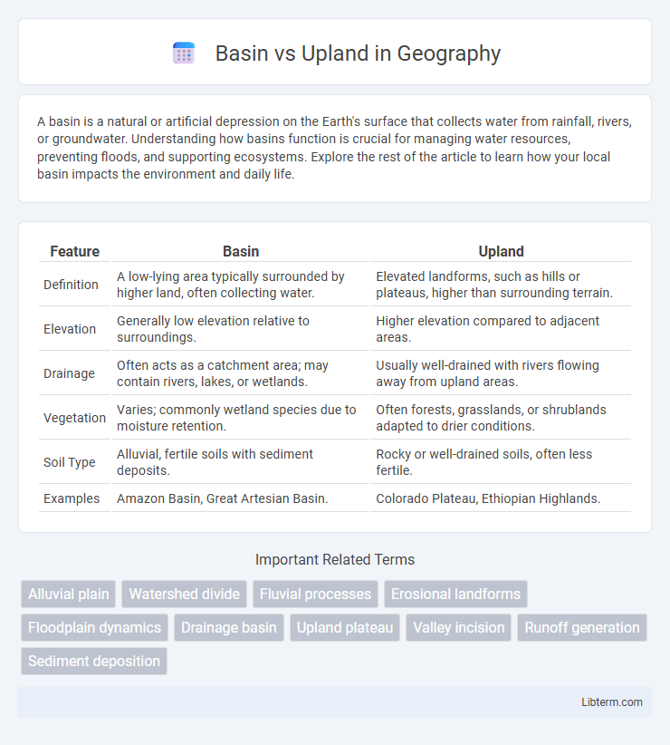
| Feature | Basin | Upland |
|---|---|---|
| Definition | A low-lying area typically surrounded by higher land, often collecting water. | Elevated landforms, such as hills or plateaus, higher than surrounding terrain. |
| Elevation | Generally low elevation relative to surroundings. | Higher elevation compared to adjacent areas. |
| Drainage | Often acts as a catchment area; may contain rivers, lakes, or wetlands. | Usually well-drained with rivers flowing away from upland areas. |
| Vegetation | Varies; commonly wetland species due to moisture retention. | Often forests, grasslands, or shrublands adapted to drier conditions. |
| Soil Type | Alluvial, fertile soils with sediment deposits. | Rocky or well-drained soils, often less fertile. |
| Examples | Amazon Basin, Great Artesian Basin. | Colorado Plateau, Ethiopian Highlands. |
Introduction to Basins and Uplands
Basins are low-lying geological depressions often characterized by sediment accumulation and water drainage, forming key features in hydrology and geology. Uplands refer to elevated land areas, typically with higher altitude and rugged terrain influencing erosion and watershed patterns. Understanding the distinction between basins and uplands is crucial for studying landform development, climate impact, and resource distribution.
Defining Basins: Key Characteristics
Basins are low-lying geological depressions typically surrounded by higher land such as uplands, often characterized by sediment accumulation and water collection. These areas frequently serve as natural reservoirs for rivers, lakes, and aquifers due to their topographic and hydrological properties. The presence of fine-grained sediments and stratified layers within basins distinguishes them from uplands, which are elevated regions with well-drained soils and minimal sediment build-up.
Uplands Explained: Features and Significance
Uplands are elevated landforms characterized by higher altitude and distinct topography compared to surrounding areas, typically featuring hills or plateaus. These regions play a crucial role in watershed management by influencing the flow and distribution of surface water, often acting as sources for rivers and streams. Uplands support unique ecosystems due to their diverse climate and soil conditions, making them significant for biodiversity conservation and agricultural practices.
Formation Processes: Basin vs Upland
Basins form primarily through subsidence due to tectonic activities such as crustal extension, rifting, or flexural loading, leading to sediment accumulation in low-lying areas. Uplands develop mainly from tectonic uplift, erosion-resistant rock formations, or volcanic activity that raises the land above surrounding terrain. The contrasting formation processes result in basins being depressions that collect sediments, while uplands are elevated regions shaped by uplift and erosion.
Ecological Differences Between Basin and Upland
Basin ecosystems are characterized by lower elevation, often featuring wetlands and higher soil moisture content, supporting hydrophilic plant species and diverse aquatic fauna. In contrast, upland areas exhibit well-drained, nutrient-poor soils, favoring xerophytic vegetation and terrestrial wildlife adapted to drier, more exposed conditions. These ecological differences drive distinct biodiversity patterns and influence nutrient cycling and habitat availability across the landscape.
Human Activities in Basins and Uplands
Human activities in basins often include intensive agriculture, urban development, and industrial operations due to fertile soils and water availability. In contrast, uplands are typically utilized for forestry, grazing, and mining, given their rugged terrain and lower soil fertility. Water management challenges differ, with basins facing flood control issues while uplands focus on soil erosion prevention.
Water Resources: Basin vs Upland Comparison
Basins collect and store surface water from precipitation, making them critical for reservoirs, rivers, and wetlands, while uplands primarily influence groundwater recharge through infiltration and soil permeability. Basin areas often experience higher water availability for ecosystems and human use, whereas uplands contribute to regulating water flow and quality by filtering runoff and reducing erosion. The dynamic interplay between basins and uplands is essential for maintaining regional hydrological balance and water resource sustainability.
Soil Types and Fertility in Basin and Upland Regions
Basin regions typically feature alluvial soils rich in nutrients due to sediment deposition from surrounding highlands, resulting in high fertility ideal for agriculture. Upland areas often have well-drained, thin, and acidic soils with lower organic matter content, leading to moderate to low fertility. Soil moisture retention and mineral composition vary significantly between basins and uplands, influencing crop selection and land use patterns.
Biodiversity Variations: Basin vs Upland
Basin ecosystems typically exhibit higher moisture levels and richer soil nutrients, fostering diverse plant and animal species adapted to wetland and aquatic habitats. Upland areas, characterized by drier conditions and well-drained soils, support unique biodiversity with species adapted to harsher, nutrient-poor environments and greater temperature fluctuations. Variations in altitude, water availability, and soil composition between basins and uplands create distinct ecological niches, driving significant differences in species richness and community composition.
Conclusion: Basin and Upland in Environmental Context
Basin ecosystems, characterized by enclosed or low-lying areas that collect water and sediments, play a crucial role in biodiversity support and nutrient cycling. Upland regions, typically higher elevation zones with well-drained soils, influence watershed dynamics and serve as vital habitats for specialized flora and fauna. Understanding the distinct environmental functions of basins and uplands is essential for effective watershed management and conservation strategies.
Basin Infographic