Isohaline refers to a line on a map or diagram that connects points of equal salinity in a body of water, such as oceans or estuaries. Understanding isohaline patterns is crucial for marine biologists and environmental scientists studying water circulation, ecosystems, and the impact of salt concentration on marine life. Explore the rest of the article to discover how isohaline mapping influences environmental monitoring and management strategies.
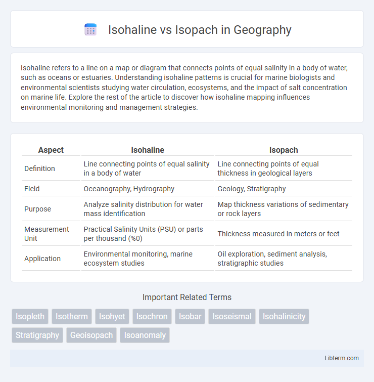
Table of Comparison
| Aspect | Isohaline | Isopach |
|---|---|---|
| Definition | Line connecting points of equal salinity in a body of water | Line connecting points of equal thickness in geological layers |
| Field | Oceanography, Hydrography | Geology, Stratigraphy |
| Purpose | Analyze salinity distribution for water mass identification | Map thickness variations of sedimentary or rock layers |
| Measurement Unit | Practical Salinity Units (PSU) or parts per thousand (%0) | Thickness measured in meters or feet |
| Application | Environmental monitoring, marine ecosystem studies | Oil exploration, sediment analysis, stratigraphic studies |
Understanding Isohaline: Definition and Importance
Isohaline refers to a line on a map that connects points of equal salinity, critical for studying oceanographic and estuarine environments where salt concentration varies. Understanding isohalines helps in tracking water mass movements, identifying mixing zones, and managing marine ecosystems impacted by salinity changes. Unlike isopach maps that represent thickness variations of geological layers, isohaline maps specifically address salinity distribution, making them essential for hydrological and environmental research.
What is Isopach? Key Concepts Explained
Isopach refers to a line on a map connecting points of equal thickness in geological or sedimentary layers, crucial for interpreting subsurface structures and sediment distribution. Unlike isohaline, which maps equal salinity levels in bodies of water, isopach emphasizes stratigraphic thickness variations significant in fields like petroleum geology and sedimentology. Understanding isopach maps assists geologists in estimating reservoir volumes and identifying depositional patterns.
Distinguishing Isohaline and Isopach: Core Differences
Isohaline maps represent lines of equal salinity in bodies of water, crucial for marine and environmental studies focusing on salinity distribution and water quality. Isopach maps, by contrast, depict layers of equal thickness in geological formations, widely used in petroleum geology and stratigraphy for analyzing sediment deposition and subsurface structures. The core difference lies in their parameters: isohaline measures salinity concentration, while isopach quantifies thickness, serving distinct scientific and practical applications.
Applications of Isohaline in Oceanography
Isohaline lines, representing constant salinity in oceanographic maps, are essential for studying water mass distribution and mixing in marine environments. They assist researchers in tracing saline water flows, understanding ocean circulation patterns, and monitoring the impact of freshwater inputs on coastal ecosystems. Isohaline data contribute to climate models by revealing changes in salinity that affect ocean density and thermohaline circulation.
Isopach Uses in Geological Mapping
Isopach maps are essential in geological mapping for illustrating the thickness variations of sedimentary rock layers, aiding in the identification of depositional environments and structural features. These maps provide valuable insights for hydrocarbon exploration by highlighting reservoir thickness and potential trap locations. Isohaline maps, in contrast, depict salinity distribution but do not directly inform on stratigraphic thickness or subsurface geology.
Methods for Mapping Isohalines
Mapping isohalines involves collecting and analyzing salinity data from water samples across different locations, typically using conductivity sensors or salinity probes at various depths. Geographic Information System (GIS) software is employed to interpolate salinity values and generate continuous contour lines representing equal salinity concentrations, allowing precise delineation of isohaline patterns. Advanced remote sensing techniques and hydrographic surveys complement these methods by providing high-resolution spatial data to enhance the accuracy of isohaline mapping.
Techniques for Constructing Isopach Maps
Isopach maps represent the thickness of geological units and are constructed by measuring vertical distances between stratigraphic horizons, often using well logs or seismic data as primary sources. Techniques for constructing isopach maps include digitizing thickness data from cross-sections, interpolating between control points using methods like kriging or inverse distance weighting, and integrating 3D seismic interpretation for enhanced spatial accuracy. Isohaline maps, contrastingly, delineate lines of equal salinity, requiring different data such as water sample analyses, and their methodologies do not overlap with the specific stratigraphic thickness measurements essential for isopach map construction.
Isohaline vs Isopach: Comparative Analysis
Isohaline and Isopach maps both illustrate subsurface data, with Isohaline maps representing lines of equal salinity and Isopach maps depicting thickness variations of geological layers. Isohaline maps are crucial for hydrogeological studies, helping to assess aquifer salinity distribution, while Isopach maps guide sedimentology and stratigraphic analysis by revealing depositional thickness changes. Understanding the distinction between Isohaline and Isopach maps enhances geological modeling accuracy and resource management decisions.
Significance in Environmental and Earth Sciences
Isohaline maps illustrate zones of equal salinity in aquatic environments, crucial for understanding water quality, ecosystem health, and pollutant dispersion. Isopach maps represent thickness variations of sedimentary layers, essential for geological stratigraphy, resource exploration, and sediment deposition studies. Both tools provide critical spatial data enabling accurate environmental assessments and earth science modeling.
Future Prospects and Research Trends
Isohaline and isopach maps continue to play a crucial role in geospatial analysis, with future research focused on integrating advanced remote sensing technologies and machine learning algorithms to enhance data accuracy and predictive modeling. Emerging trends emphasize the development of multispectral and hyperspectral imaging to refine salinity gradients in isohaline mapping and improve stratigraphic resolution in isopach studies. Advances in real-time monitoring and data fusion techniques are expected to drive significant improvements in environmental management, resource exploration, and climate change impact assessments.
Isohaline Infographic