Topography plays a crucial role in shaping the natural and built environments by detailing the arrangement of landforms such as hills, valleys, and plains. Understanding topographical features benefits fields like urban planning, agriculture, and outdoor recreation by providing essential information about elevation and terrain. Explore the rest of the article to discover how topography impacts your surroundings and practical applications.
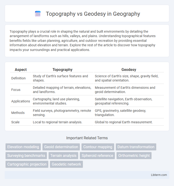
Table of Comparison
| Aspect | Topography | Geodesy |
|---|---|---|
| Definition | Study of Earth's surface features and shapes. | Science of Earth's size, shape, gravity field, and spatial orientation. |
| Focus | Detailed mapping of terrain, elevations, and landforms. | Measurement of Earth's dimensions and geoid determination. |
| Applications | Cartography, land use planning, environmental studies. | Satellite navigation, Earth observation, geospatial referencing. |
| Methods | Field surveys, photogrammetry, remote sensing. | GPS, gravimetry, satellite geodesy, triangulation. |
| Scale | Local to regional terrain analysis. | Global to regional Earth measurement. |
Introduction to Topography and Geodesy
Topography involves the detailed mapping and charting of surface features of the Earth, emphasizing natural and man-made landmarks such as mountains, rivers, and roads. Geodesy focuses on measuring and understanding the Earth's geometric shape, gravitational field, and rotation to achieve precise positioning and navigation. Both disciplines play critical roles in land surveying, cartography, and civil engineering by providing accurate spatial data and models.
Defining Topography: Key Concepts
Topography focuses on the representation of the Earth's surface features, including elevations, landforms, and natural and man-made structures, through detailed maps and contour lines. It emphasizes the spatial arrangement and shape of terrain elements to aid in navigation, land use planning, and environmental studies. Key concepts in topography involve relief depiction, scale accuracy, and terrain modeling techniques essential for geographic information systems (GIS) and surveying applications.
Understanding Geodesy: Fundamental Principles
Geodesy is the science of measuring and understanding Earth's geometric shape, gravitational field, and rotational dynamics, providing critical data for accurate mapping and navigation. Unlike topography, which primarily represents surface features like terrain and natural landmarks, geodesy involves precise calculations of Earth's size, shape, and spatial orientation using satellite geodesy, GPS, and geodetic surveys. Fundamental principles of geodesy include the use of reference ellipsoids, geoid models, and coordinate systems to establish accurate positional frameworks essential for various scientific and engineering applications.
Historical Evolution of Topography and Geodesy
Topography and geodesy have evolved distinctly, with topography primarily focused on detailed mapping of Earth's surface features for local and regional planning since ancient civilizations. Geodesy developed as a scientific discipline during the 18th century with precise measurements of the Earth's shape, size, and gravitational field to support navigation, cartography, and geospatial science. Advances in technology, including satellite geodesy, have refined the understanding of Earth's geoid, while topography continues to benefit from remote sensing and digital elevation models for detailed terrain analysis.
Tools and Techniques in Topographic Surveying
Topographic surveying utilizes tools such as total stations, GPS receivers, and digital levels to accurately measure land elevation, contours, and features. Techniques include triangulation, traversing, and leveling, often enhanced by drone photogrammetry and LiDAR scanning for high-resolution data acquisition. These methods enable precise mapping and 3D modeling of terrain essential for construction, land development, and environmental studies.
Geodetic Methods and Technologies
Geodetic methods employ satellite systems such as GPS and GNSS to precisely measure the Earth's shape, gravitational field, and spatial positioning, offering centimeter-level accuracy for large-scale mapping. Technologies like laser scanning, interferometric synthetic aperture radar (InSAR), and satellite laser ranging are integral to geodesy, enabling detailed monitoring of tectonic shifts, sea-level changes, and geoid determination. Unlike topography, which focuses on surface features and elevation data for localized mapping, geodesy provides foundational reference frames critical for accurate navigation, earth science research, and global positioning systems.
Major Differences Between Topography and Geodesy
Topography involves the detailed mapping and charting of surface features, emphasizing elevation and landform visualization, while geodesy focuses on measuring and understanding the Earth's shape, gravitational field, and orientation in space with high precision. Topography primarily deals with local spatial variations and terrain modeling, whereas geodesy integrates global-scale data for applications like satellite positioning and geophysical studies. The major difference lies in topography's emphasis on surface detail and geodesy's broader scope of Earth's geometric and gravitational properties.
Applications of Topography in Modern Science
Topography plays a crucial role in modern science by providing detailed representations of the Earth's surface, essential for environmental monitoring, urban planning, and natural disaster management. Its applications extend to geological surveying, hydrology, and civil engineering, where precise landform mapping supports infrastructure development and resource management. Geodesy complements topography by focusing on measuring Earth's shape and gravitational field for accurate global positioning and navigation systems.
Geodesy in Navigation and Earth Sciences
Geodesy plays a crucial role in navigation and Earth sciences by precisely measuring and understanding Earth's geometric shape, orientation in space, and gravitational field, enabling accurate positioning and mapping. Unlike topography, which focuses on depicting surface features, geodesy provides the foundational reference systems essential for satellite navigation, global positioning systems (GPS), and tectonic plate movement analysis. Its data integration supports climate monitoring, sea level change studies, and geospatial information system (GIS) accuracy, advancing scientific research and practical navigation applications worldwide.
Conclusion: Choosing Between Topography and Geodesy
Choosing between topography and geodesy hinges on project scale and precision requirements, as topography deals with detailed surface features for smaller areas while geodesy focuses on Earth's shape and gravity over large regions. Opt for topography for construction, landscaping, or local mapping where detailed terrain data is essential. Select geodesy in applications demanding global positioning, satellite navigation, or crustal movement monitoring that require high-accuracy Earth measurements.
Topography Infographic