Datum refers to a single piece of information or a fact used as a basis for reasoning or analysis in various fields such as science, statistics, and data management. Understanding the importance of accurate datum ensures more reliable research outcomes and informed decision-making. Explore the rest of this article to uncover how effective use of datum can enhance your data-driven strategies.
Table of Comparison
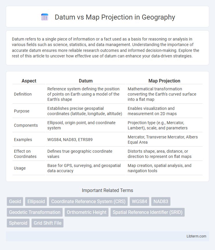
| Aspect | Datum | Map Projection |
|---|---|---|
| Definition | Reference system defining the position of points on Earth using a model of the Earth's shape | Mathematical transformation converting the Earth's curved surface into a flat map |
| Purpose | Establishes precise geospatial coordinates (latitude, longitude, altitude) | Enables visualization and measurement on 2D maps |
| Components | Ellipsoid, origin point, and coordinate system | Projection type (e.g., Mercator, Lambert), scale, and parameters |
| Examples | WGS84, NAD83, ETRS89 | Mercator, Transverse Mercator, Albers Equal Area |
| Effect on Coordinates | Defines true geographic coordinate values | Distorts shape, area, distance, or direction to represent on flat maps |
| Usage | Base for GPS, surveying, and geospatial data accuracy | Map creation, spatial analysis, and navigation tools |
Understanding Geospatial Foundations: Datum and Map Projection
Datum defines the reference frame for measuring locations on Earth by establishing an origin and orientation, ensuring positional accuracy in geospatial data. Map projection transforms the curved surface of the Earth into a flat, two-dimensional plane, enabling spatial analysis and cartographic visualization while introducing inherent distortions. Understanding the interplay between datum and map projection is essential for accurate mapping, data integration, and geospatial decision-making.
Defining Geographic Datum: The Reference Framework
A Geographic Datum serves as a crucial reference framework by providing a mathematical model that defines the size and shape of the Earth for mapping and surveying purposes. It establishes the origin and orientation of latitude and longitude coordinates, enabling accurate positioning and spatial data alignment. Without a consistent datum, geographic data can vary significantly, leading to errors in location-based applications and map projections.
What Are Map Projections? Transformation from Globe to Map
Map projections are systematic methods used to transform the three-dimensional surface of the Earth onto a two-dimensional plane, enabling the creation of flat maps. This transformation involves mathematical formulas that convert geographic coordinates--latitude and longitude--into planar coordinates, which inevitably introduce distortions in area, shape, distance, or direction. Different map projections, such as Mercator, Robinson, or Lambert conformal conic, are chosen based on the purpose of the map and the type of distortion that can be minimized or tolerated.
Key Differences Between Datum and Map Projection
A datum defines the size and shape of the Earth and serves as a reference point for geographic coordinates, while a map projection transforms the 3D surface of the Earth onto a 2D plane. Datum deals with the positioning of locations in space, incorporating parameters like ellipsoid models and reference points, whereas map projection involves mathematical algorithms to represent the curved surface with minimal distortion of area, shape, distance, or direction. The choice of datum affects coordinate accuracy and consistency, whereas the selection of map projection is crucial for preserving geometric properties depending on the map's purpose.
The Role of Datum in Coordinate Accuracy
A datum provides a reference framework for measuring locations on the Earth's surface, defining the origin and orientation of latitude and longitude coordinates. It establishes the relationship between the coordinate system and the Earth's shape, ensuring spatial data is accurately aligned with real-world positions. Without a precise datum, map projections can introduce significant errors in coordinate accuracy, leading to misrepresentation of geographic features.
How Map Projections Impact Spatial Visualization
Map projections transform the curved surface of the Earth onto a flat plane, causing distortions in area, shape, distance, or direction that influence spatial visualization. Different projections, such as Mercator, Robinson, or Lambert Conformal Conic, prioritize preserving certain spatial properties, affecting how geographic information appears and is interpreted. Understanding these distortions is crucial for accurately analyzing spatial relationships and making informed decisions in fields like cartography, GIS, and navigation.
Common Types of Geodetic Datums
Common types of geodetic datums include WGS84, NAD83, and ED50, each serving as a reference framework for measuring locations on the Earth's surface. These datums provide the foundation for map projections by defining the shape and size of the Earth, crucial for accurate spatial data representation. Selecting an appropriate geodetic datum ensures compatibility and precision in geographic information systems (GIS) and cartography.
Popular Map Projection Methods Explained
Popular map projection methods, including Mercator, Lambert Conformal Conic, and Albers Equal Area, transform the Earth's curved surface from a specific datum into a flat, two-dimensional map. Each projection optimizes for different properties such as area, shape, distance, or direction, making them suitable for various applications like navigation, thematic mapping, or large-scale regional planning. Choosing the appropriate projection depends on the map's intended use and the datum's coordinate reference system, ensuring accurate spatial representation and minimal distortion.
Choosing the Right Datum and Projection for Your Project
Selecting the right datum and map projection is crucial for ensuring geographic accuracy and minimizing spatial distortions in your project. Use a local or regional datum like NAD83 or ETRS89 when working within North America or Europe for higher positional accuracy, while global datums such as WGS84 suit worldwide applications. Choose map projections based on your project's purpose: use conformal projections like Mercator for navigation accuracy, equal-area projections like Albers for preserving area in statistical maps, and azimuthal projections for maintaining true direction from a central point.
Practical Implications: Datum vs Map Projection in GIS Applications
Datum defines the reference framework for accurately positioning geographic data on the Earth's surface, while map projections transform this curved surface onto a flat plane, inherently introducing distortions in area, shape, distance, or direction. Selecting an appropriate datum ensures spatial data aligns correctly across different GIS layers, crucial for precise location-based analyses such as surveying, navigation, or environmental modeling. Understanding the practical limitations of map projections allows GIS professionals to minimize errors by choosing projections suited to the study area's scale and geographic extent, enhancing the reliability of spatial measurements and visualization.
Datum Infographic