Cartography involves the art and science of making maps, combining geographic data with design principles to visually represent spatial information. Advanced GIS technologies and remote sensing have revolutionized modern cartography, enabling more accurate and interactive maps. Explore this article to discover how cartography shapes our understanding of the world and enhances navigation and planning for your needs.
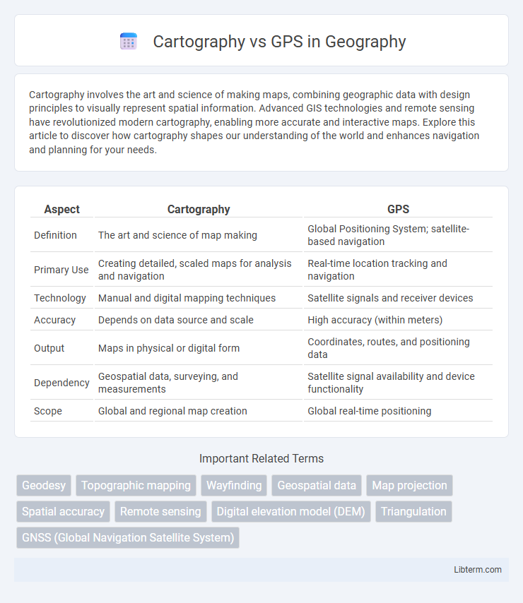
Table of Comparison
| Aspect | Cartography | GPS |
|---|---|---|
| Definition | The art and science of map making | Global Positioning System; satellite-based navigation |
| Primary Use | Creating detailed, scaled maps for analysis and navigation | Real-time location tracking and navigation |
| Technology | Manual and digital mapping techniques | Satellite signals and receiver devices |
| Accuracy | Depends on data source and scale | High accuracy (within meters) |
| Output | Maps in physical or digital form | Coordinates, routes, and positioning data |
| Dependency | Geospatial data, surveying, and measurements | Satellite signal availability and device functionality |
| Scope | Global and regional map creation | Global real-time positioning |
Introduction to Cartography and GPS
Cartography is the art and science of creating maps that represent spatial information visually, emphasizing geographic features, scale, and design for effective communication. GPS (Global Positioning System) technology provides real-time, satellite-based location data, enabling precise navigation and positioning across various environments. While cartography focuses on map creation and interpretation, GPS delivers dynamic, accurate geospatial information critical for modern navigation and geographic analysis.
Historical Evolution of Navigation Methods
Cartography, dating back to ancient Mesopotamia, laid the foundation for navigation by creating detailed maps representing geographic features and human settlements. GPS technology emerged in the late 20th century, revolutionizing navigation with satellite-based positioning systems offering real-time, high-precision location data globally. The historical evolution from manual map-making to automated satellite navigation highlights the transition from interpretive spatial understanding to precise, dynamic spatial awareness.
What is Cartography?
Cartography is the science and art of creating maps that visually represent geographical information by integrating data such as terrain features, political boundaries, and cultural landmarks. It involves the use of various tools and techniques to accurately depict spatial relationships and convey complex geographic data in a clear, understandable format. Unlike GPS, which provides real-time location tracking and navigation based on satellite signals, cartography focuses on the design, interpretation, and communication of geographic information through static or dynamic visual media.
How GPS Technology Works
GPS technology operates by triangulating signals from a network of at least 24 satellites orbiting the Earth, allowing GPS receivers to determine precise locations. Each satellite transmits time-stamped microwave signals, which the GPS device calculates based on the time delay to establish exact coordinates. This method offers real-time, dynamic positioning, contrasting with traditional cartography's static map representations.
Key Differences Between Cartography and GPS
Cartography involves the traditional art and science of creating, studying, and interpreting maps, emphasizing spatial relationships and detailed geographic features. GPS relies on satellite signals to provide real-time location data and navigational guidance, offering dynamic and precise positioning information. The key difference lies in cartography's static representation of geographical information versus GPS's dynamic, real-time tracking and navigation capabilities.
Advantages of Traditional Cartography
Traditional cartography offers detailed, context-rich maps that provide a comprehensive understanding of geographical features, cultural landmarks, and historical data. Unlike GPS, which depends on satellite signals and electronic devices, paper maps function without power sources, making them reliable in remote or signal-poor areas. The craftsmanship involved in traditional map-making also enhances spatial cognition and navigation skills through manual interpretation of scale, symbols, and terrain.
Benefits of GPS in Modern Navigation
GPS technology offers real-time location tracking with unparalleled accuracy, enabling precise navigation for both personal and commercial use. Unlike traditional cartography, GPS provides dynamic route updates, traffic data, and integration with mobile devices, enhancing travel efficiency and safety. The widespread availability of GPS accelerates emergency response, fleet management, and outdoor activities by delivering reliable, instantaneous geographical information.
Limitations of Maps vs. Limitations of GPS
Maps provide a static representation of geographic information that can become outdated due to natural or human-made changes, limiting their accuracy over time. GPS relies on satellite signals that can be obstructed by tall buildings, dense forests, or atmospheric conditions, causing signal loss or reduced precision. While maps lack real-time updates and are dependent on user interpretation, GPS requires electronic devices and power sources, which may fail or be unavailable in remote areas.
Real-World Applications: Cartography and GPS
Cartography enables the creation of detailed maps used in urban planning, environmental monitoring, and navigation systems, providing a visual representation of geographical data. GPS technology offers real-time location tracking and route guidance, essential for logistics, transportation, and emergency response. Combining cartography with GPS enhances spatial analysis by overlaying dynamic positional data on accurate, designed maps.
Future Trends in Navigation Technology
Future trends in navigation technology emphasize the integration of advanced cartography with real-time GPS data to enhance spatial accuracy and user experience. Emerging innovations include augmented reality mapping, AI-driven predictive routing, and ultra-precise satellite systems such as GPS III and Galileo, which improve positioning reliability and reduce errors. These developments are reshaping navigation by providing dynamic, personalized maps and smarter location-based services in industries like autonomous vehicles and urban planning.
Cartography Infographic