Geomorphology studies the Earth's surface features and the processes shaping them, including erosion, sedimentation, and tectonic activity. Understanding these natural forces helps predict landscape changes and manage environmental challenges effectively. Explore the rest of the article to deepen your knowledge of how geomorphology impacts your environment.
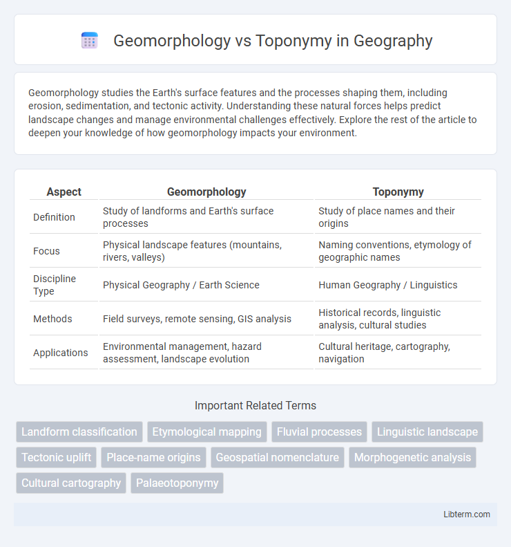
Table of Comparison
| Aspect | Geomorphology | Toponymy |
|---|---|---|
| Definition | Study of landforms and Earth's surface processes | Study of place names and their origins |
| Focus | Physical landscape features (mountains, rivers, valleys) | Naming conventions, etymology of geographic names |
| Discipline Type | Physical Geography / Earth Science | Human Geography / Linguistics |
| Methods | Field surveys, remote sensing, GIS analysis | Historical records, linguistic analysis, cultural studies |
| Applications | Environmental management, hazard assessment, landscape evolution | Cultural heritage, cartography, navigation |
Introduction to Geomorphology and Toponymy
Geomorphology studies the formation, evolution, and configuration of Earth's landforms, analyzing processes like erosion, sedimentation, and tectonic activity shaping physical landscapes. Toponymy explores the origin, meaning, and use of place names, reflecting cultural, historical, and linguistic influences on geographic nomenclature. Understanding geomorphology provides scientific insights into physical terrain, while toponymy offers a cultural lens on how humans perceive and label these natural features.
Defining Geomorphology: Study of Earth's Landforms
Geomorphology is the scientific study of Earth's landforms, examining their origin, evolution, and processes such as erosion, sedimentation, and tectonic activity. This discipline analyzes landscapes including mountains, valleys, plateaus, and rivers to understand physical geography and geological history. In contrast, toponymy focuses on the study of place names and their linguistic, cultural, and historical significance rather than the physical characteristics of the land.
Understanding Toponymy: The Significance of Place Names
Toponymy, the study of place names, reveals rich linguistic, cultural, and historical information embedded within geographic locations. Unlike geomorphology, which examines physical landforms and their processes, toponymy focuses on the origins, meanings, and patterns of place names, helping to interpret human interactions with the environment. Understanding toponymy provides insights into settlement history, migration, and cultural identity tied to specific regions and landscapes.
Key Differences Between Geomorphology and Toponymy
Geomorphology studies the physical features and processes shaping Earth's surface, analyzing landforms such as mountains, valleys, and rivers based on geological activity and erosion. Toponymy focuses on the origin, meaning, and use of place names, examining cultural, historical, and linguistic influences on geographic nomenclature. The key difference lies in geomorphology's emphasis on natural landscape formation, while toponymy centers on the human aspect of naming and interpreting geographic locations.
The Role of Geomorphology in Environmental Studies
Geomorphology plays a critical role in environmental studies by analyzing landforms and their processes to understand ecosystem dynamics, natural hazards, and climate change impacts. It provides essential insights into soil erosion, sediment transport, watershed management, and terrain stability, which are crucial for sustainable land use planning and disaster mitigation. By interpreting geomorphic features, researchers can predict environmental changes and guide conservation efforts more effectively than relying solely on toponymy, which focuses on the linguistic origins of place names rather than physical landscape processes.
Toponymy’s Cultural and Historical Importance
Toponymy studies place names, revealing insights into cultural heritage, historical events, and linguistic evolution within a region. Unlike geomorphology, which analyzes landform processes and physical terrain features, toponymy captures human experiences and societal values embedded in geographic nomenclature. This field aids historians and anthropologists in understanding settlement patterns, migration, and the influence of indigenous or colonial narratives on modern maps.
Methods and Tools Used in Geomorphological Research
Geomorphological research employs remote sensing, Geographic Information Systems (GIS), and Digital Elevation Models (DEMs) to analyze landforms and earth surface processes with high precision. Field surveys and sediment analysis complement these tools by providing direct measurement of soil composition and erosion patterns. In contrast, toponymy uses linguistic databases and historical cartographic records to study place names, focusing on cultural and etymological data rather than physical landscape features.
Approaches to Analyzing and Documenting Place Names
Geomorphology approaches place names by examining the physical landforms and natural features that influence naming conventions, using spatial analysis and remote sensing to link names with terrain characteristics. Toponymy focuses on the linguistic, historical, and cultural origins of place names, employing etymological research and archival records to document their meanings and evolution. Integrating Geographic Information Systems (GIS) enhances both fields by enabling precise mapping, pattern recognition, and comprehensive databases for structured analysis and preservation of place name data.
Real-World Applications: Geomorphology vs Toponymy
Geomorphology analyzes landforms and processes shaping Earth's surface, essential for environmental management, hazard assessment, and urban planning. Toponymy studies place names, aiding in cultural heritage preservation, geographic information systems (GIS), and navigation systems. Integrating geomorphology with toponymy enhances spatial analysis and decision-making in land use, disaster risk reduction, and historical geography.
Interdisciplinary Connections and Future Perspectives
Geomorphology and toponymy intersect through their shared focus on Earth's surface features and place names, revealing cultural and environmental relationships. Integrating geographic information systems (GIS) and remote sensing enhances spatial analysis, fostering deeper insights into landscape evolution and naming conventions. Future research emphasizes cross-disciplinary collaboration, leveraging big data and machine learning for dynamic mapping and preserving indigenous toponyms linked to geomorphological phenomena.
Geomorphology Infographic