Isochrone maps visualize areas reachable within a specific time frame from a given point, offering crucial insights for urban planning, transportation, and emergency services. Understanding isochrones can help optimize routes, improve accessibility, and enhance decision-making processes. Explore the rest of the article to discover how isochrones can transform your spatial analysis and strategic planning.
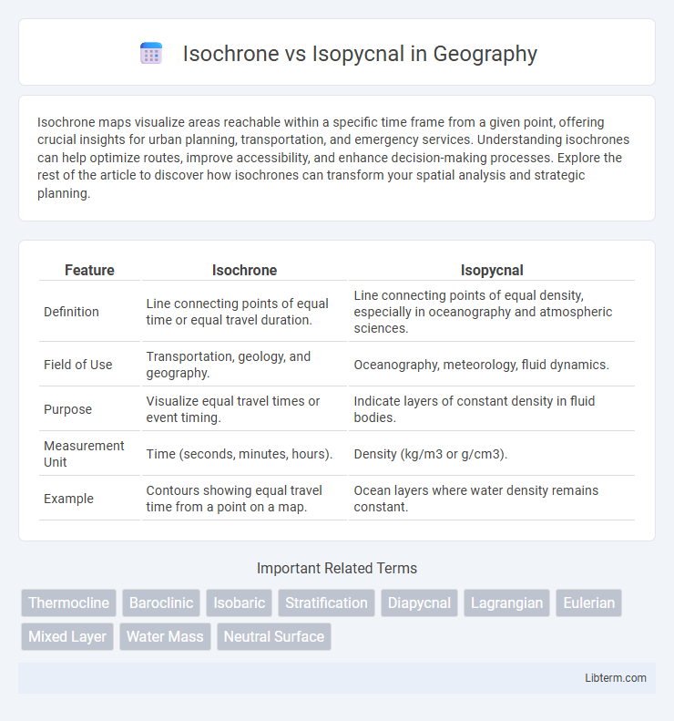
Table of Comparison
| Feature | Isochrone | Isopycnal |
|---|---|---|
| Definition | Line connecting points of equal time or equal travel duration. | Line connecting points of equal density, especially in oceanography and atmospheric sciences. |
| Field of Use | Transportation, geology, and geography. | Oceanography, meteorology, fluid dynamics. |
| Purpose | Visualize equal travel times or event timing. | Indicate layers of constant density in fluid bodies. |
| Measurement Unit | Time (seconds, minutes, hours). | Density (kg/m3 or g/cm3). |
| Example | Contours showing equal travel time from a point on a map. | Ocean layers where water density remains constant. |
Introduction to Isochrone and Isopycnal Concepts
Isochrone lines represent points of equal travel time from a specific location, crucial for spatial analysis in transportation and urban planning. Isopycnal surfaces connect points of equal density in fluid dynamics, vital for understanding ocean mixing and stratification. These concepts facilitate the interpretation of temporal and density variations in geospatial and environmental studies.
Definition of Isochrone
Isochrone refers to a line on a map connecting points where a process or event occurs simultaneously or within the same time frame, often used in transport and hydrology studies. In contrast, isopycnal lines connect points of equal density in fluid dynamics and oceanography, highlighting density variations in a medium. Understanding isochrones aids in analyzing time-dependent phenomena, while isopycnals assist in studying the stratification and flow patterns of fluids.
Definition of Isopycnal
An isopycnal is a surface or line in a fluid where the density remains constant, commonly used in oceanography and meteorology to analyze water or air masses. Unlike an isochrone, which represents equal time intervals or events occurring simultaneously, isopycnals are crucial for understanding stratification and mixing processes in natural fluids. These surfaces help identify layers with uniform density, facilitating the study of fluid dynamics and energy transfer.
Key Differences Between Isochrone and Isopycnal
Isochrone lines represent equal time intervals, often used in fields like hydrology or transportation to indicate locations reached in the same amount of time, whereas isopycnal lines connect points of equal density within fluid bodies, crucial in oceanography and atmospheric sciences for tracking fluid movement and stability. Isochrones emphasize temporal uniformity, while isopycnals focus on spatial density uniformity and stratification. The key difference lies in isochrones being time-based isolines and isopycnals being density-based isolines, each serving distinct analytical purposes in their respective domains.
Physical Principles Underlying Isochrones
Isochrones represent lines of equal travel time for fluid parcels, reflecting the physical principle of time-dependent flow dynamics governed by advection and dispersion processes. These curves are crucial in hydrodynamics and oceanography for mapping the temporal evolution of water masses, contrasting with isopycnals, which indicate surfaces of constant density driven by buoyancy and stratification physics. Understanding isochrones involves analyzing flow velocity fields and temporal transport mechanisms rather than density variations that define isopycnal surfaces.
Physical Principles Underlying Isopycnals
Isopycnals represent surfaces of constant density within a fluid, fundamentally governed by the balance of pressure, temperature, and salinity variations that determine fluid stratification. These density layers influence fluid motion and stability, reflecting the gravitational equilibrium where fluid parcels neither rise nor sink along isopycnal surfaces. Unlike isochrones, which track equal time intervals, isopycnals emphasize the physical principle of buoyancy equilibrium, crucial for understanding oceanographic and atmospheric circulation patterns.
Applications of Isochrones in Earth Sciences
Isochrones represent lines connecting points of equal age or time, crucial for dating geological formations and sediment layers. In Earth sciences, isochrones help reconstruct paleoenvironments by mapping sediment deposition rates and stratigraphic correlations. These applications facilitate understanding of tectonic processes, sedimentary basin evolution, and seismic hazard assessments.
Applications of Isopycnals in Oceanography and Meteorology
Isopycnals, surfaces of equal density, are crucial in oceanography for tracing water mass movements and analyzing vertical mixing, helping to understand thermohaline circulation and stratification. In meteorology, isopycnals assist in studying atmospheric stability and buoyancy by revealing layers of constant air density, which influence weather patterns and cloud formation. These applications enable more accurate modeling of ocean currents and atmospheric dynamics essential for climate prediction.
Visualization Techniques for Isochrones and Isopycnals
Visualization techniques for isochrones utilize contour plots and 3D surfaces to represent equal travel times or ages within a fluid or geological medium, often enhanced by color gradients to denote temporal changes. Isopycnals are commonly visualized through density contour maps or volume renderings that highlight layers of constant density, frequently paired with velocity fields to analyze fluid dynamics. Advanced visualization tools integrate GIS and oceanographic software platforms to dynamically display both isochrones and isopycnals, facilitating comprehensive spatial and temporal analyses.
Summary: Choosing Between Isochrone and Isopycnal Analyses
Isochrone analysis maps areas reachable within equal travel time, ideal for transportation and urban planning to assess accessibility and efficiency. Isopycnal analysis investigates surfaces of equal density in oceanography or atmospheric studies, crucial for understanding fluid dynamics and stratification. Select isochrone methods for time-based spatial evaluations and isopycnal approaches for density-driven environmental or geophysical investigations.
Isochrone Infographic